
There will be a second City Council hearing on the massive NC55-Hopson rezoning and annexation proposal Monday, February 7th (see durhamnc.gov/AgendaCenter/City-Council-4/ for the January 3rd agenda with details and the February 7th agenda will be available here closer to the meeting).
The rumored extension of Hopson from 55 to Grandale is discussed in Amendment #4 to the Durham-Chapel Hill-Carrboro Metropolitan Planning Organization’s Comprehensive Transportation Plan, up for public comment through Tuesday, February 22 ( www.dchcmpo.org/what-we-do/programs-plans/comprehensive-transportation-plan ). The amendment would change the planned connection from a road with a median to a road without a median, and would include bicycle lanes and sidewalks. Nothing is said about how Grandale would be modified for additional traffic.
Amendment #4 also brings up a new issue of concern. Nothing is said about changes to Grandale Road, but images in the report show Grandale being extended south of Wake Road, in Chatham County. It is unclear whether the road extension would cross Kit and Panther creeks, major tributaries of Northeast Creek, or cut through publicly owned bottomland forest along the creeks.
In 2017 the Wildlife Resources Commission commented about the plan to extend Hopson Road, regarding fragmentation of important and intact natural areas and the impact of construction on aquatic life. These plans go against the recommendations in the NC Natural Heritage Program inventories, quoted in an earlier post. If Hopson Road is extended, would extending it west of Grandale be the next step, since the extension as proposed would not connect with Scott King Road directly? Building a new road paralleling Northeast Creek would be a threat to wildlife that regularly crosses between the bottomlands and uplands, such as amphibians and turtles. Obviously there would be polluted runoff, light pollution, traffic noise, and litter from a new road. Grandale Road near the Creek already poses a problem for wildlife, with a lot of roadkill at times, and the government is aware of this, but seeks to worsen the problem with these plans. Much of the existing traffic on Grandale seems to be coming from or going to Cary, so would this environmentally damaging road expansion in Durham mainly be for the benefit of Cary and Chatham County?
Durham city and county supposedly seek to reduce local greenhouse gas emissions, but they build new roads to fill with cars and extending Hopson would probably involve a great deal of blasting and earthmoving, since Hopson currently faces a steep hillside on one of the highest ridges in the area and on the east side of 55 it cuts through another high ridge. Hopson has been re-routed a number of times and used to end at TW Alexander Drive (since Hopson was extended to 55 this section has been made part of the new Louis Stephens Road), after a mostly straight path for many miles. I think bus service curently only extends as far south as the corner of TW Alexander and 55.
The report dates the Hopson Road extension plan only to 2017, but I thought the idea had been defeated many years ago, so it could be prevented again, as was the idea of a connector paralleling the Eno. On the other hand, so much is being proposed around, or through, one of the largest and wildest areas of unbroken wild land along Northeast Creek, with many people living nearby and enjoying the public gameland along the creeks, yet there hasn’t been much of an uproar. Maybe people are still unaware of what is planned.
The 2050 Metropolitan Transportation Plan is also open for public comment, through February 1st. It is unclear what the 2050 Plan would mean for the Northeast Creek basin. The plans are at 5-year intervals.
City Council hearing on NC55 – Hopson tonight, January 3rd
The Durham City Council will hold a virtual hearing regarding the 55-Hopson annexation and rezoning request tonight, Monday, January 3rd. There will also be hearing on 2211 Page Road. Below are some comments, mostly reiterating what has been posted here earlier:
I am not necessarily against building anywhere on this vast site but I have several concerns about this application and some issues tied to this application but not addressed in any public meetings that I am aware of, especially road expansion.
The entire proposed project extends from the east side of Highway 55 to within sight of Grandale Road, an area probably a mile or more across, and this is the site I am commenting about, not only the smaller, but still very large, portion the applicant wants rezoned Industrial Light. It appears that the staff report recommends just zoning Industrial, if IL is deemed acceptable, but I only just noticed this and have not looked into what that would allow. [The staff report and other documents are linked from the meeting agenda, posted at durhamnc.gov/AgendaCenter/City-Council-4/ ]
There is too much ambiguity about what would be built where. There would be few limits on construction near the neighbors, and much of the site was clearcut, including the portion closest to Audubon Park and Parkwood at the north end. The clearcutting is convenient for the Kimley-Horn memorandum on the environmental condition of the site, though it should be noted that a field or young pine forest is still habitat for some species. Rare plants such as pink ladyslipper orchids might prefer relatively young pine forests and red-tailed hawks hunt over fields and clearcutting probably benefits deer.
The publicly-owned bottomlands along Northeast Creek are noted as a buffer, but they are not that wide and I would like to hear some concern about avoiding harm to this land and those who use it. At times many vehicles are parked along Grandale on a weekend. The Federal land is managed as gameland by the NC Wildlife Commission and if hunting decreases because of building there might be an increase in the number of deer in nearby neighborhoods, which is probably already high. There is also the issue that some species might need larger areas of forest than just what is protected on public land, or species might need upland as well as bottomland habitat, so construction could lead to the loss of species despite the large amount of protected land. There is also the issue of species associated with human activity, such as English ivy, Norway rats, and feral cats, coming in and harming native plants and animals. Nearby I have seen some non-native trees common on vacant land downtown sprouting on clearcut land and utility corridors, though so far they are uncommon in this part of Durham.
There is talk of a 40-50′ buffer around the site, but most of the land has already been cut, though large saplings have grown since then.
The NC Natural Heritage Program inventory reports noted nesting black-and-white warblers and probably nesting sharp-shinned hawks and the presence of ribbon snakes as rare animal species in the areas studied along Northeast Creek at the south end of the County, as well as Douglass’ bittercress and other state or regionally rare or unusual plants, and there were otters and mink along the Creek, but the area has not been re-surveyed since 1999. The most recent Durham report recommended that “Preservation of upland buffers along the edges of the bottomlands should be given a high priority. These slopes provide denning areas for terrestrial species, as well as refuges during periods of high water” while the 1999 Jordan Lake Inventory recommends that “No more utility corridors should be allowed in the area” along the Creek between 55 and 751. These recommendations directly relate to this rezoning application, but aren’t being brought up.
This site is already vast, and I suspect that the Wrenn family’s land to the west, which was also recently clearcut, is available for sale. Does the applicant know something the public doesn’t? I am concerned that approving the rezoning under consideration will be the signal to sell more land in the area, so the near future of a larger area is in question. Similarly there was a lot of change along Ellis Road over a short period. The applicant says that housing will be built at the south end of Grandale and a new road will connect 55 and Grandale. What are Cary’s plans along the county line? In recent years they did so much just south of the county line, along Kit and Panther creeks, major tributaries of Northeast Creek.
I am not aware of any discussion of the government’s road plans relating to this site. There are rumors that there are plans for a new connection from 55 to Grandale and that Grandale will be widened. While it might not be ideal, there is already a connection between 55 and Grandale along the county line, but made harder to use by the changes along 55 around a decade ago. If Hopson were extended, there would still be a jog to get to Scott King Road, so would the DOT next want to extend Hopson to 751, crossing the very large and mostly unbroken publicly owned forest along Northeast, Crooked, and Kit creeks and the Tobacco Trail? I was informed that the Durham-Chapel Hill-Carrboro Comprehensive Transportation Plan calls for a “major thoroughfare” from the intersection of Hopson and 55 to Grandale, though nothing is listed in the State Transportation Improvement Program from now to 2033. The application shows a road passing north of the abandoned claypit, which I think is also part of the site that has older trees and steep slopes. A lot of blasting would be required, since 4-lane Hopson currently ends at a steep hillside, on one of the highest ridges in the area. When they blasted away the hill at the corner of TW Alexander and 55 nearby, working day and night, it could be heard for miles and I think there were complaints to the police from Scott King Road. Building new roads obviously contributes to climate change, aside from the traffic and deforestation, and there are already connecting roads. How would a new road change traffic patterns? Traffic has increased on Grandale, probably because of all of the recent building in Wake County, and there is a lot of roadkill. I remember a report demonstrating that the government knows that Grandale at Northeast Creek is a chokepoint for wildlife movement. Would the bridge be raised so that wildlife might tend to cross underneath, as was discussed where expanded 15-501 crosses New Hope Creek? The bend at the bridge on Grandale isn’t very safe for pedestrians and bicyclists and neither is Scott King Road, site of a future elementary school. Many turkey and black vultures used to or still roost close to Grandale and might be driven off, as well as other wildlife. The Kimley-Horn memorandum notes a past report of a waterbird colony and I saw a heron rookery near Grandale. A large amount of traffic, usually going much faster than the speed limit, on residential Sedwick Road is a problem now, but it would probably increase on Grandale and Scott King if Hopson were extended, even if it decreased on Sedwick. I have heard that building new roads tends to increase traffic overall, increasing carbon dioxide emissions. It would be less polluting if the existing rail connection could be used for freight or passengers, but it is on the east side of 55.
If Grandale were widened, it would be good to improve parking at the bridge and maybe more traffic would decrease the risk of harassment there. I use that area and there are other people who hike, hunt, or fish, and people probably still drive ATVs on the City, County, Federal, and Parkwood land. On the other hand maybe a new business park would be like the Ellis Research Center on Ellis Road east of 147 and put up signs threatening the public on a public road and reflecting badly on Durham.
An IL zoning allows many possible uses, and there is not a gurantee about what would actually be built. It is possible that an office type business park would be more environmentally benign than housing, though possibly an unkempt junkyard would be more benign than a business park with close-cropped, chemical and fossil fuel-dependent lawn and large parking lots. Freight would increase traffic and air pollution and waste management would probably increase windblown litter as well as air pollution.
Would IL zoning allow large greenhouses? That would seem to fit with research and development use. The “buffer” provided by Northeast Creek would not be enough to prevent a significant impact on Audubon Park and Parkwood. I live miles away from greenhouses near the intersection of TW Alexander and Highway 54 but I see an area of especially bright orange or yellow light reflected when there are low clouds (higher clouds also get lit up, but the light is less glaringly obvious) and when it is clear that light is still there, obscuring my view of the sky. This is a huge impact, but the UDO considers all of this stray light indoors and therefore not regulated, though the night sky is lit up for miles. I’m not sure that I have ever seen the Milky Way and light pollution in the Triangle must increase every year. The Stonesthrow apartments are adjacent to the greenhouses and don’t need streetlights when there are low clouds.
Greenhouses would have a large impact on the bottomlands along Northeast Creek, and there is the more ordinary light pollution from parking lots and area lights and also noise. The area is currently relatively dark and this large rural area of forests and fields probably serves as a refuge for many nocturnal species. Fireflies of several species are numerous and for more than 10 years I have observed at a location on Grandale for the Firefly Watch program. Fireflies are much more abundant at Grandale than along my street and I see more species there, though I live near woodlands. Bobcats have been seen several miles away at Jordan Lake and it is possible that they live at the south end of Durham and are an example of a rare species that would be driven out by light and noise pollution. I thought birds such as chuck-will’s-widow and whippoorwills had been driven out of the Triangle, but then I encountered one at the elementary school site nearby, obviously trying to lead me away from a nest or chicks. River otters live in Northeast Creek nearby if not here, and turkeys, and wood ducks can be seen near Grandale.
What would be done to prevent chemical releases, including gases, adjacent to Northeast Creek? The applicant notes how far Audubon Park and Parkwood are from the Triangle Wastewater Treatment Plant and compares it to the distance between those communities and this site. At one time the WWTP probably had a large quantity of gaseous chlorine on site and it is my understanding that in the event of a chlorine release that buffer would not have been enough for safety. Things have improved, but at one time the WWTP and/or the sewer lines could be smelled strongly in the Frenchman’s Creek and Audubon Park area if not in Parkwood and the Creek had a strong chlorinated smell as it left Durham County around Grandale. I have heard from City employees that Northeast Creek or other creeks have elevated copper levels because of aerial fallout from a smelter downtown and organic chemicals that might come from the freeways. What about the escape of GMOs or disease-causing organisms?
Where would the utilities be located? Fragmenting a forest by putting in utility easements can reduce its utility for forest species and encourages cowbirds, non-native plants, etc. I think there was discussion of building a pipeline for 751 South though here at one point. At that time I thought Durham had a policy of not extending water utilities south of Scott King Road.
The report lists many items that might be good to have in the planning process, but then they are rendered useless if there is not a development plan. There are obviously plants, animals, communities, and ecosystems on the site, since it is a location on the living Earth (though after mass grading the site would like more like a tract on a lifeless celestial body). It is very easy to avoid finding things. I would be surprised if there are not any steep slopes, such as around the old claypit and near 55, and the site seems to include wetlands, such as along the high-tension powerline. The claypit might also count as a wetland and looks like a lake in the recent aerial photo. The photo might show the remains of that ancient hill overlooking 55 at TW Alexander, blasted away as fill for the toll road, with the excess dumped in the claypit.
It would seem likely that there are at least scattered archaeological remains on the hillsides overlooking Northeast Creek and there is a small cemetery on Green Level Church Road near the claypit and 55. I think local universities found significant fossils in the claypit and it is a historic use, so it would be good to preserve it in some form. I found plant fossils a few miles away. There are igneous rock outcroppings in the area, which could encourage rare plants, besides the low level of disturbance by human activity in recent decades, aside from the clearcutting. The claypit is a former industrial use, but as far as I know it is not polluted and has been left in a natural state, without any buildings or trash, though there have been tobacco barns in the general area.
The announcement that this case would be on the Council’s agenda came in late December, before the agenda was even posted, presumably because of the holidays, and the public might not have been paying attention because of the holidays.
Seasonal Nature Notes for winter
This is a revised version of an article I wrote for Cathy Starkweather’s South Durham Green Neighbors Newsletter, posted each month on the sdgreenneighbors Googlegroup (there is also a Facebook group), outlining some of the natural sights and wonders people can look out for this winter.
Seasonal Nature Notes
Despite the cold winter weather, some plants regularly or potentially bloom in December. East Asian camellias bloom in yards from fall into spring, depending on the variety. They don’t seem very attractive to insects, but yellowjackets check them out in the fall. Red maples can start blooming well before spring and when they do small insects can be seen flying around the canopy on relatively warm days. Many years ago pastel pale blue bluets bloomed in December outside Eno River State Park’s main office, though they normally bloom months later. Peaches on the south-facing side of Occoneechee Mountain in Hillsborough also bloomed in winter that year and still developed fruit. There were cold temperatures that winter, and there were frigid and icy mornings on the shaded north side of the small mountain. I was surprised to see a white atamasco or Easter lily, usually a flower of mid-spring, blooming near Little Creek in Orange County in early November 2020, after herbaceous brush had been cleared. Hepatica, a pale lavender to blue, and occasionally white or pink, early spring woodland wildflower often found on rocky hillsides, can bloom in January or February if not December. Witch-hazel, a diminutive relative of sweetgums, also might bloom on hillsides around now. This is also a good time of year to look for evergreen mistletoe, a semi-parasitic bush growing in the bare treetops. It is common on silver and red maples near the intersection of Sedwick and Revere roads and it often appears on oaks along city streets in downtown Durham, Chapel Hill, Cary, and Raleigh. It seems to be most common in built up areas but sometimes grows on red maples around beaver ponds and large waterways. It was unusual to see one high in a Northern red oak surrounded by other trees at Cary’s Hemlock Bluffs Nature Preserve, near but not immediately next to Swift Creek. There are a few deciduous tree species that mistletoe seems to prefer, but it can grow on a range of native and non-native trees. Recently I have been admiring the shape of the fallen leaves, especially those of Spanish or Southern red oaks. There are many species of oak, each with a different leaf shape, and the form of each leaf is individual, depending on how shaded it was, its history during the growing season, etc. Oaks are among the last trees to lose their leaves, probably finishing in early December, and some oaks and other trees regularly retain their earth-colored dead leaves until spring, at least when young. The whitish paperlike leaves of related American beech, increasingly common in Parkwood, are picturesque in brilliantly lit deciduous woods in winter. Lingering winged seeds can be seen in the skyscraping crowns of bare tuliptrees along Northeast Creek and the sweetgum gumballs won’t fall off for a few more months and attract seedeating birds during the winter. Fruit might linger on plants such as greenbriars, hollies, hawthorns, and Japanese privet while December is likely too late for the last American and Asian persimmons. Apparently cedar waxwings can be poisoned during the winter by the red fruit of Nandina, an East Asian shrub with compound leaves.
It seems like live oaks drop their acorns in winter and other oaks might still be scattering the last of their acorns in early December. The official Landscape Manual for Durham recommends against planting Virginia live oaks, native along the coast into Virginia, but those growing around the old Parkwood Shopping Center, at the intersection of Revere and Seaton roads, don’t appear to have any problems with damage from cold temperatures or ice and their acorns, very abundant under the trees around now, sprout if scattered in yards while still viable. The only drawback might be that they grow slowly, at least when somewhat shaded. Live oaks are evergreen, hence their common name, but might have fewer leaves during the winter. Young oaks of many species are often semi-evergreen or retain dead leaves in winter, and water oaks, which are native to Durham and have reached a pretty large size in some yards and on the UNC campus, are a little closer to being evergreen. This is another native oak Durham seems to unfairly malign, claiming that it is prone to “untreatable decay,” and they have problems with the supposedly “exotic” pin oak, which seems to be native in central NC if not Durham. They did not seek public input before updating the manual in 2020. Oaks often turn red in the fall, some species strikingly so, but when fallen leaves are picked up they are usually more brown than red.
This is a good time to look for migratory waterfowl, including American coots, pied-billed grebes, ring-billed gulls, non-resident Canada geese, and ducks such as black scoters, long-tailed ducks, and mergansers. Some species, such as hooded mergansers, can stay well into the spring and might breed here but it seems like the majority of the migrants fly north by or in February. I like to look for them at Crabtree Lake in Cary but they also visit Parkwood Lake, large stormwater ponds, the waterfowl impoundments, and sometimes even small beaver ponds (see my February 2014 article at www.northeastcreek.org/wordpress/784/ ). I sometimes spot unusual shorebirds, terns, etc. at various times at the large reservoirs, but only one or a few at a time and it is easier to search smaller lakes. Migrating shorebirds can also turn up on dry shorelines around small beaver ponds. Small flocks of colorful wood ducks can be seen in Northeast Creek now, but they are very wary and I usually only catch a glimpse as they shriek and fly off. Woodcocks or just their tracks and probings can be found along waterways in winter, though I might see them more often in late winter than now. Seeing a well-camouflaged woodcock usually means not seeing it until one gets close and it flies away, though maybe not with quite the speed of a wood duck. Flocks of turkeys and their tracks can also be found in bottomlands in winter; despite their reputed wariness about 20 landed above me in a swampy area after sunset on a Thanksgiving Day, and I think they didn’t fly off as I left. Maybe they were experienced enough to know I wasn’t hunting. According to John K Terres they roost over water for protection from great horned owls and presumably other predators. Woodcocks start displaying around January and the NC Botanical Garden usually has excursions to see their displays, rising 300 feet in the air above open areas at nearby Mason Farm Biological Reserve as night falls. Barred owls, bald eagles, and hooded mergansers are among the birds that can begin to breed in December or January. The plaintive calls of yellow-bellied sapsuckers are a common winter sound in Parkwood. These migratory woodpeckers spend winter here, chiseling rows of holes in many tree and shrub species for sap; they also eat insects. They breed further north and at high elevations in Western NC. Other birds and insects also visit sapsucker holes, potentially including overwintering butterflies. Wounded trees, as well as fruiting persimmons,are good places to look for butterflies in the fall. The ground can be heavily littered with fruit under untended pear trees, but in my experience they don’t seem very attractive to butterflies and other insects, or maybe it is late in the season.
Winter is also a good time to observe some insect life stages, such as the egg masses of mantises and Eastern tentworms and the large cocoons of some giant silk moth species. I frequently see large cocoons dangling from the twig tips of birch planted around buildings. Some species attach their cocoons to the twigs while others allow their cocoons to fall with the leaves, one reason it is important to leave fallen leaves. For example, both promethea or spicebush and tuliptree silk moth caterpillars can be found on tuliptrees, but promethea caterpillars usually spin their cocoons so they won’t fall while tuliptree moths let them fall. Related polyphemus moth caterpillars usually either travel to the ground to pupate or fall with the leaves. Sometimes they do attach their cocoons to twigs, and these might be the cocoons I see on birch. This group of very large moths can be found in Parkwood and there are plants for their caterpillars, but they seem more abundant in places like UNC and Falls Lake. Insects have many ways of surving winter and one frigid winter morning I jostled a holly and very small green inchworm caterpillars dangled on silk, though the ground below was hard with ice. At other times I have seen insects and spiders out as snow melts. Carolina wrens and other birds can be seen investigating lingering dead leaves. The various species forage in different ways, searching the tips of branches or along trunks and working in different directions, avoiding competition. Galls created by insects or other organisms can be seen on the stems of goldenrods and other plants. Under hickories carefully pruned twigs can be found, cut off by twig girdling beetles. The round exit holes of weevil grubs can be seen in this year’s acorns and other nuts. Don’t bring eggs masses, cocoons, etc. indoors for long or they might hatch early, with disastrous results. It is now safe to examine the nests of social paper wasps, often hidden in brush or under eaves and bald-faced hornet nests suspended from tree branches. I sometimes find the tiny mud vases of solitary potter wasps hidden in closed up wild carrot or Queen Anne’s lace seedheads. Even on what seem like freezing nights some moths can be on the wing, as well as bats. I found a large gray hoary bat roosting at ground level on the outside of UNC’s Greenlaw building one day in mid-January. During warm spells hibernating butterflies and moths can appear and in some cases last year’s caterpillars emerge as adults, possibly too early. Black swallowtail butterflies, especially males, frequently hatch when it seems too early, and it might have been on a night at the end of a warm spell in December, with the wind picking up as a cold front approached, that I saw a large pastel green luna moth unseasonably fly by a streetlight at Eno River State Park.
Depending on the weather early spring frogs can start singing in December. I sometimes hear individual frogs call quietly on mild, cloudy days in the fall and while species such as upland chorus frogs are so loud in late winter and early spring it might be easier to actually see them in the fall and summer. Marbled salamanders silently court and lay eggs in dry depressions in early fall, females guarding their eggs until these vernal pools fill up. The dark brown or black larvae with a collar of frilly gills can be seen, developing front legs first, unlike frog and toad tadpoles. What are probably marbled salamander larvae can be seen in the bottomlands around Northeast Creek and in puddles next to some nearby roads. Like frogs and toads they can breed in pools created by human activity, though they seem to prefer ‘wilder’ pools. Construction destroyed some nearby breeding pools and might have killed off the adults and they also get killed crossing roads to reach their customary breeding locations. Closely related spotted salamanders breed later, dancing underwater in the now brimming pools, and their larvae can be prey for the older marbled salamander larvae. At least in the case of spotted salamanders breeding adults prefer to return to their natal pool, and can follow the same route every year. I haven’t ever found an adult spotted salamander myself, so as far as I know they aren’t found in southern Durham County, but I occasionally find marbled salamanders hidden under debris on moist hillsides near creeks. Spotted salamanders famously breed in large vernal pools at the NC Botanical Garden in Chapel Hill and there are usually tours, which fill up quickly. One or more small salamander species can be found in Parkwood’s streams, possibly only breeding there, but they are well hidden or uncommon so I rarely see them. Salamander biodiversity is very high in North Carolina but they are usually not as conspicuous as frogs and toads.
I think of lizards as animals of summer but Carolina or green anoles are easy to see in the fall and winter. I first noticed them in Parkwood about 10 years ago and several moved into my yard in the summer of 2020. I wonder if this is a sign of climate change, but they were known in Chapel Hill by at least 1995 and according to roadsendnaturalist.com/2021/09/05/yard-mystery/ anoles have lived in that part of Chatham County for at least decades. I started seeing them in Orange County around the same time as in Parkwood and a few years ago they were common in places at Jordan Lake State Recreation Area. I haven’t seen them further north near the Eno, though Falls Lake is a rich in reptiles, including species that I had not realized live in the piedmont. Despite changing color to match their surroundings, anoles are conspicuous and I would have noticed if many had been living around here. Last fall and winter I would often see them on sunny south-facing walls and an air-conditioning unit, even in December, and I was afraid that they might not survive the winter, but they did and were out again this year. Fence lizards live or lived at Parkwood Elementary School, spiraling around trees to escape capture, but otherwise seem very rare in this part of the Triangle. They are common in places at Falls Lake State Recreation Area. I found one near the Eno on a cold, wet day, probably in late fall or early winter, but it seemed dangerously chilled. I can’t recall seeing any skinks out in fall or winter.
The Northern Hemisphere’s winter solstice is Tuesday, December 21st this year, when the night will be longest. Daylength changes little from day to day close to the solstice, but changes faster closer to spring. I thought the first frost was usually in mid-November, and that was the case this year, but some sources ( such as gardening.ces.ncsu.edu/average-first-and-last-frost-dates/ ) say it is earlier. We can get significant snow in December, but the coldest temperatures are usually in the New Year, in late January, when snowstorms are more likely and snow and ice can linger. The Earth’s orbit actually takes us closest to the Sun during the Northern Hemisphere’s winter, but the Earth’s tilt reduces the amount of heating produced by the Sun’s rays and it takes time for the land and oceans to warm or cool. For a few years it seemed like we often had balmy weather in late December. So far mild to warm weather is forecast for much of early December.
Winter is the best time to see atmospheric phenomena created when sun or moonlight interacts with ice crystals in motion, in clouds such as cirrus and cirrostratus, though optical phenomena can appear in any season. There are many kinds, including various haloes around the Sun or Moon, often indicating approaching stormy weather; sun and even moondogs, also called mock suns/moons and parhelia/paraselene, on one or both sides of the Sun or Moon; circumzenithal arcs, like rainbows in the center of the sky; and many other kinds, ranging from relatively common to very rare. Around midday on about November 15, 1996 the sky over southern Durham seemed to be full of lines and I wonder if anyone else noticed. That might have been when I first noticed sundogs. There are also the optical effects created by water droplets; rainbows are more common in the summer, but coronas often form around the Moon when it shines through a thin bank of the mid-level cloud altocumulus.
With the Sun setting early and the trees bare, this is also a good time to see both the colorful sunset in the west and the bands of color in the east as we enter the Earth’s shadow.
The night sky is also interesting and the sky is often limpid if burning cold in winter. Venus, Saturn, Jupiter, and Mercury will be plainly visible in the evening and Uranus and Neptune will be visible through binoculars. Before dawn on the 31st the delicate, gleaming white waning crescent Moon, reddish Mars, and the reddish star Antares, in the heart of the constellation Scorpius, will appear close together low in the southeast. Scorpius appears shortly before the Sun rises now, but is up much of the night during the summer. Comet C/2021 A1 (Leonard) might become bright enough to be visible to the unaided eye, after having spent tens of thousands of years approaching the inner solar system. On the 17th Comet Leonard will appear near Venus. There are other comets in the sky as well, but they are not expected to become very bright. Ceres, the largest object in the Asteroid Belt, will be visible using binoculars in the constellation Taurus. It was the first asteroid discovered, January 1, 1801, and could harbor extraterrestrial life.
There are several annual meteor showers, mostly weak, with only a handful of meteors per hour on average, or even fewer. Some but not all of the showers potentially visible now are listed below, based on David H Levy’s The Sky: A User’s Guide, the American Meteor Society’s website (see below), and other guides. The Southern Taurids already peaked, but can be seen until December 2nd; they are relatively slow-moving and often form bright fireballs. The Northern Taurids are also supposed to end December 2nd. Meteor showers are named for the constellation they appear to radiate from, in this case Taurus, but they can be seen looking elsewhere in the sky. The Leonids are visible November 3rd to December 2nd, peaking November 18th, and these meteors have the greatest speed of any annual shower. Andromedids appear occasionally but not every December and the AMS says this shower ends December 2nd. The Monocerotids can be seen until December 26th, peaking on the 11th. The Geminids are supposed to be the strongest meteor shower of the year, visible December 4th – 17th peaking early on the 14th. The Geminid and Leonid showers are strongest, especially the Geminids, but the Moon and light pollution can lower the count even if it is a clear. Showers can vary in strength and some occasionally produce extraordinary storms of meteors. There is a Leonid storm every 33 years. The Ursids are visible December 17th – 26th and peak on the 22nd. The Coma Berenicids are visible until December 23rd and peak December 15th. The Quadrantids, named for Quadrans Muralis a superseded constellation bordering the Big Dipper or Ursa Major in the north, are visible December 28th – January 7th and peak briefly on January 3rd. Some years I’ve tried to see all of the main showers.
Satellites and sometimes larger objects, such as the very bright International Space Station, can be seen passing slowly overhead (some of the websites below give the dates and times when the ISS and other objects transit over the area). It is easy to see satellites early in the night and in the pre-dawn hours, when they are bathed in sunlight while we are in shadow. Huge numbers of satellites, mainly “constellations” of communications satellites, are being sent into low Earth orbit now, a growing problem for astronomers and other satellites.
Some of Parkwood’s green areas are good places for stargazing, but are closed at night, though I suggested to the Parkwood Association that it would be good to have places to look at the sky. There are also more streetlights, but it is possible to request that they be better shielded or removed altogether ( the contacts were listed in the Association’s newsletter a few years ago). Despite streetlights the areas around Revere and Seaton roads; places along Highway 54, such as the watershed between Northeast and Crooked creeks, topped by Barbee Road; large ponds and lakes; and possibly Southpoint Mall, despite all of its lights, have good views down towards the horizon. The Jordan Lake Wildlife Observation Site off Martha’s Chapel Road and the nearby gamelands don’t seem to have closing times and state parks are open all night for campers. CHAOS, the Chapel Hill Astronomical and Observational Society, organizes local events and trips to darker locations and Morehead Planetarium at UNC hosts events.
Stargazing:
Heavens-above.com
spaceweather.com
skyandtelescope.com
astronomy.com
amsmeteors.org
chaosastro.org
moreheadplanetarium.org
spacewatchtower.blogspot.com
Atmospheric optical phenomenon:
atoptics.co.uk
atoptics.wordpress.com
See also the Audubon and Peterson weather/atmosphere guides; the Peterson guide has diagrams showing many of the optical effects.
The Planning commission vote on 55-Hopson
At the Tuesday, October 12th meeting the Planning Commission voted 12-0 against recommending the Industrial Light rezoning around the intersection of Hopson Road and 55, bordering RTP and extending west, south across Northeast Creek from several communities. Members of the public had about 3 minutes each to comment and a few neighbors and I spoke. As I recall the comments were generally questions or negative on the proposed rezoning and there were not any ringing endorsements. I wasn’t the only person to bring up light pollution and I think noise was an issue at the community consultation meeting in January if not on the 12th. One or more neighbors mentioned concern for wildlife, and mentioned seeing a bald eagle in their yard, but without noting that the adjacent gameland was inventoried by the NC Natural Heritage Program as an important natural area in Durham County and greater Jordan Lake that ideally should not be disturbed further and is also used for hunting and fishing. There was a proposal to move to a text-only development plan addressing some of the concerns brought up at the hearing, to be heard again in 60 days, but the original application was voted upon in the end. Despite this negative recommendation by the Commission the proposed rezoning could soon go to City Council. So far nothing has been announced.
The applicant said that their plan is to build a business park housing valuable biomedical companies, but I wonder if the research and development component of an Industrial Light zoning would allow large greenhouses, similar to those on TW Alexander Drive and Davis Drive. When there are low clouds light reflected from large greenhouses is conspicuous for miles and when it is clear the light isn’t so obvious but still contributes to light pollution obscuring the night sky over the Triangle. Humanity has been able to look up and see the Milky Way as well as other galaxies for thousands of years, but I’m not sure if I have ever been able to see our greater galaxy from the Triangle or anywhere. An Industrial Light zoning allows many uses, including warehouses, recycling centers, junkyards, wholesale trade, etc. Some of these uses would probably increase windbown litter, traffic, noise, and air pollution.
Would there be a risk of hazardous material spills? Early in the applicant’s presentation to the Commission the relatively large distance between this site and neighborhoods to the north was compared with the distance between the nearby Triangle Wastewater Treatment Plant on 55 and the neighborhoods. Not so long ago the Triangle Wastewater Treatment Plant used chlorine for disinfection, leaving Northeast Creek with a chlorinated smell far downstream, so presumably there was a supply of chlorine gas on site. If there had been a leak houses were probably dangerously nearby and today houses have been built even closer. The rezoning application predicts additional residential building just west of the site, along Grandale. It should also be noted that while houses are relatively far, Northeast Creek is very close to parts of the site and is the reason there is a buffer of forest between the site and the north neighborhoods.
Besides whatever noise would come from the construction and operation of whatever is built, a large area would hear and maybe feel the blasting and earthmoving necessary to cut through the ridge at the corner of 55 and Hopson and other hills for a new road. The DOT would probably want a road similar to Hopson, which has four divided lanes cutting through a ridge on the east side of 55. Earlier this month the BBC talked about the climate change impact of new building construction, and here is a plan to build a major new road when there are already roads connecting 55 to Grandale. Ignoring the impact on wildlife, would a new road significantly reduce traffic on existing roads and would that be the end of major road building along Northeast Creek at the very south margin of Durham County? A railroad, which is probably less carbon-intensive than trucking, is on the other side of 55 from the majority of the site. Local governments claim to be trying to reduce Durham’s contributions to climate change.
There is very little information about what would actually be built and where and the opportunity for regular public input ends once the City Council approves a rezoning.
55-Hopson and MLK rezoning hearings at the planning commission tonight
Tonight (October 12th) at 5:30 the Planning Commission will hear two rezoning requests in the Northeast Creek basin, a large Industrial Light project proposed along the edge of the County around the intersection of Highway 55 and Hopson Road and apartments at the northeast corner of Fayetteville Road and Martin Luther King Jr Parkway. I have been paying the most attention to the 55-Hopson proposal, but I did not realize its full significance until a few days ago, so this post is at the last minute. Tonight is not the final hearing. There are or have been some other rezoning requests along the Creek this year. This will be an online meeting through Zoom; registration is at:
zoom.us/webinar/register/WN_Az71ESRRSPumnJMjRXPEMg
More information about participating:
durhamnc.gov/4062/Participate-in-a-Virtual-Public-Hearing
The application, referenced below, is available in the agenda posted at:
durhamnc.gov/AgendaCenter/Planning-Commission-15
See also Durham’s new supplemental Social PinPoint system:
durham.mysocialpinpoint.com/land-use/map#/sidebar/tab/about
I wrote about this and some other proposals earlier in the year at:
www.northeastcreek.org/wordpress/where-the-red-fire-pink-blows-and-other-campions-in-the-triangle/
After the Planning Commission there would be a hearing before the City Council. Below are some comments.
Hopson-55 rezoning
The staff report incorrectly said this site is in the Neuse River basin, but I think this is being corrected to the Haw and ultimately Cape Fear basin. Legal definitions must be being used at the bottom of page 4, because there are obviously plants, animals, communities, and ecosystems on the site, since it is a location on the living Earth (though after mass grading the site would like more like a tract on a lifeless celestial body). It is very easy to not find any rare or protected species or historical relevance. The report lists many items that might be good to have in the planning process, but then they are rendered useless by saying that they do not apply in the absence of a development plan.
There are references to extending Hopson Road west of 55 on page 32, etc. The rezoning request only covers part of the area discussed at the community meeting, but obviously the applicant must intend to build in the entire area, looking at page 34, etc. The clearcutting over the last 10 years from 55 to Grandale leads me to suspect that all of this land is being sold, so does the applicant have plans or know something the public doesn’t know? It’s possible the logging was done so they could then say on page 53 that the communities discussed in the NC Natural Heritage Program reports no longer exist, and without committed elements there are no guarantees about where building would be done on the site. The area north of the powerline was also clearcut, but they say it will not be built upon. When was there a hearing on building a new connecting road from 55 to Grandale? I also heard a rumor late last week that the DOT wants to enlarge Grandale. I have since been informed that the Durham-Chapel Hill-Carrboro Comprehensive Transportation Plan calls for a “major thoroughfare” from the Hopson and 55 intersection to Grandale, but nothing is listed in the State Transportation Improvement Program from now to 2033. The NC NHP repeatedly surveyed the public lands along Northeast Creek immediately bordering the proposed rezoning site and recommends that new utility easements not be built (Jordan Lake Inventory 1999) and that “Preservation of upland buffers along the edges of the bottomlands should be given a high priority” (Durham County Inventory 1995). It seems like building a major new road would have a worse impact on the environment than new utillity easements and there is already a lot of roadkill on Grandale Road around the bridge over Northeast Creek as it is, especially in late spring/early summer. When was or will the public given an opportunity to comment on road plans? How much blasting would have to be done to extend Hopson, given that it currently ends at a steep slope, on one of the highest hills in the area? Will the DOT then want to extend a road across one of the wildest parts of Northeast Creek and the Tobacco Trail to 751? There is already a connecting route from 55 to Grandale, made harder to use when the intersection was moved north, and the area around the old claypit can be accessed from the existing road.
As I said before, the application includes very little information about what is actually planned. At the community meeting (see page 41) they said the plan was for office-type biomedical buildings, but Industrial Light allows many applications, including recycling centers, warehouses, freight facilities, junkyards, wholesale, etc. It is possible a junkyard would actually be more environmentally benign than office buildings, parking lots, and lawn. Freight or recycling would probably increase roadkill and litter and have other impacts. What would be done to limit harmful chemical releases? Would the buildings be built where they would have maximum impact on the adjacent gamelands, and Parkwood and Audubon Park would also be impacted since they aren’t that far away?
What about the impact on hunting? If hunting is limited by building, there could be over-population of deer in Parkwood. Wildlife such as turkeys, wood ducks, prothonotary warblers, beavers (a subject of concern east of Parkwood this year), and possibly otters live adjacent to this site, while further away I saw a breeding female chuck-will’s-widow or whippoorwill, and I thought such birds had been driving out of the Triangle, like bobwhites.
Would IL zoning allow greenhouses, under research? I live miles from TW Alexander Drive, but I am already impacted by the light pollution from large greenhouses there, along with the new blue-white streetlights installed this year. It is less obvious, but I can probably see light pollution from the Southpoint Mall area as well. Light pollution is very obvious when there are low clouds, such as last weekend, but it reflects off dust, etc, and muddies the sky even on clear nights, so the Milky Way, which should be easy to see is barely if at all visible. Closer to the site buildings and parking lots would no doubt be lit all night and there would probably be light trespass from poorly shielded lights into the gameland. If a large greenhouse were built close to Parkwood it would probably be very bright on nearby streets when it is cloudy, and during the winter, even though there is a forested buffer, as happens at the Stonesthrow Apartments, by Burdens Creek.
What about the scientific significance of the claypit? I can’t remember the details now, but I think paleontologists at local universities have excavated significant fossils there. I have found plant fossils elsewhere where the sedimentary bedrock has been exposed a few miles away. The application says there are not any steep slopes or wetlands, but is this true of the entire area they want to build on, from 55 to near Grandale Road? The aerial photos show water in the old claypit and there are marshes in places under the powerlines, while it seems likely that there would be steep slopes around the claypit and 55.
There is a small cemetery southeast of the claypit by the road and it is likely that there are archaeological remains where ancient people could overlook the floodplain and watch for game. There is an old road of some near 55, but I don’t know of any ruins there.
Even though there is preserved land, development nearby could still cause local extinctions, for example if species are bothered by light, noise, or water pollution; needed the upland habitat on private land as well as the public bottomlands; if they need a larger area of forest than just what is preserved; or if they are harmed by non-native species such as cats, dogs, Norway rats, or English ivy that could come with increased human activity.
Some but not all of the woods in this area were clearcut over the past 10 years, but young trees have since grown back and species such as deer and red-tailed hawks have probably benefitted, and bobwhites might also like such habitat. Unlike what the application says, when I would go by over 10 years ago it seemed like the claypit was surrounded by forest, though it was relatively young, and some remains.
Apparently tree planting is a significant way to reduce the amount of carbon dioxide in the atmosphere, as the City of Durham supposedly desires, but Durham probably has fewer trees now than it did in 1995, at least in this section (though the amount of forest is probably greater than when agriculture was more prominent in Durham). Building a new road, instead of using what already exists, and relying on cars, would also contribute to climate change.
I’m not necessarily against building something and I actually find new construction interesting, but very little information is being offered, what would this project mean for nearby “vacant” land, and suddenly there is talk of a new connecting road and expanding Grandale. I am generally against making Grandale a major road and there is already too much roadkill and dangerous conditions for pedestrians and cyclists along Grandale and on Scott King Road, where an elementary school is planned. The speed limit is high, and people speed, coming on to the curved and narrow bridge over the Creek, at one time a one-lane wooden bridge on a long gravel road. Increased traffic might potentially drive off the huge numbers of turkey and black vultures that sometimes roost, though it might increase their food supply. The only benefit is that the risk of people being harassed by over-zealous neighborhood watch types and even deputies while doing legal activities might be reduced, as well as illegal dumping, though littering might increase. It might be good to have better parking by the bridge. On the other hand, given that people like or liked to joyride ATVs in the area, including on the site in question, and it borders parkland, maybe it would become Durham’s next Ellis Research Center (on the south side of Ellis Road east of 147), which has private metal signs saying “No Stopping, No Standing, No Parking” along a public road, which reflects badly on Durham and is a threat to the public.
518 Martin Luther King Jr Parkway
I am not very familiar with this site except passing by, but it is in the headwaters of Northeast Creek’s north branch and it would be good if woods were preserved, especially along the roads, the Tobacco Trail, and any streams; native plants used in landscaping; light pollution limited, etc. The woods might not be very old, but a rare pink ladyslipper orchid grew in young pinewoods where Woodcroft Parkway was extended across Fayetteville and some species prefer young or otherwise piney woods. There is already a lot of traffic at the intersection to consider and the ATT has crossings in the area. If there are steep slopes, people might throw their trash over the edge if it is made convenient and without consequences for them. It is good that the applicants say they will preserve some existing trees and include a park, though these probably aren’t binding commitments and it would be good to keep the trees along the roads. The maps show a hill on the site and it might have a good view if cleared, as did the ridge at 54 and Barbee Road, which is the watershed separating the Northeast Creek and Crooked Creek basins. This area has also become much more densely built-up in recent years, but much of it is in the Third Fork and Crooked creek basins.
Late summer soothsayers
In late July or early August last year I walked under a hackberry sapling in my backyard and thought, surely I won’t look up and see an arboreal rough green snake. Instead I was surprised to find a large green and brown mantis, and it was there almost every day through mid-September. The hackberry attracted a species of large, blueish-gray plant-sucking true bug, and the mantis ate those, and then cicadas, putting on weight. It stalked large dragonflies that perched on dead twigs but I never saw it catch one (it also stalked small katydids, but I’m not sure if it caught any). At night it rested, often upside down, its ‘beady’ green eyes turning black. Earlier that summer I saw a beautiful green nymph that might have been the same mantis. The adult was probably a female Chinese mantis (Tenodera sinensis), but it could have been a narrow-winged or Japanese mantis (Tenodera augustipennis), or a praying or European mantis, which is actually only one kind (Mantis religiosa). Later I found an eggcase, resembling that of a Chinese mantis, on a low plant nearby and nymphs are around again this year. There were also Carolina mantises (Stagomantis carolina), a small, mottled gray species with bright orange markings. One spent a night just before Halloween on a red maple snag covered with morning glories vines. There are more than 2500 species, and over 11 in the USA (and introduced species might be harming native mantises). Mantises or mantids were classified with grasshoppers as orthopterans and then given their own order, Mantodea. Mantises are closest to cockroaches and termites, and they can all be grouped together as dicytopterans.
Also in the area there are much smaller but also predaceous mantisflies, which resemble a cross between a mantis and a wasp or fly, but they are neuropterans like lacewings and antlions.
Mantis comes from Greek for prophet, and mantises are charismatic creatures worldwide. Here they have been called soothsayers, rearhorses, devil-horses (god-horse in the Caribbean), praying locusts, and mulekillers, because their dark saliva was thought to be poisonous (and blinding). In the Southwest they were called campomoche and cortón, rezadora, or just mantis in Spanish. A Japanese name is kamakiri, which appears to combine sickle and “to cut,” but this is a guess about the etymology. Another name is tōrō. T. augustipennis is called Chōsen [Korea] kamakiri in Japanese while T. sinensis is ōkamakiri (presumably big mantis). Praying mantis is la mante religieuse or prie-Dieu in French and Gottesanbeterin in German. A dictionary from ancient Assyria calls them necromancer or soothsayer-grasshoppers. In ancient Egypt the bird-fly was thought to guide the dead and in ancient Greece mantids directed lost travellers. The Southern Africa trickster god !Kaggen could appear as a mantis inspiring an Afrikaans word for mantis, Hottentotsgot. Mantids were apparently more closely observed in East Asia than in Europe and inspired two Chinese martial arts. Mantises appear on ancient Greek coins and in modern monster movies. People today talk about being abducted by mantislike beings. The Carolina mantis is South Carolina’s state insect while Connecticut’s is the praying mantis. Mantises are also popular as insect pets.
This is an excerpt from my article in the July – August issue of Triangle Gardener magazine, available at many libraries, public gardens, and gardening-related stores in the Triangle and posted online at: www.trianglegardener.com
Some resources:
A key to the mantises of Florida, but useful elsewhere:
entnemdept.ufl.edu/choate/mantid_key2_03.pdf
Carolina mantises:
Praying mantises:
Chinese mantises:
Narrow-winged mantises:
Asian jumping mantises (recently found in Virginia and north apparently):
bugguide.net/node/view/1738253
animaldiversity.org/site/accounts/information/Stagmomantis_carolina.html/ (Carolina mantis)
animaldiversity.org/accounts/Tenodera_aridifolia/ (Chinese mantis listed under an old classification or a closely related species)
“Praying mantids of the United Statesn, native and introduced,” a detailed article in the 1950 Annual Report of the Board of Regents of the Smithsonian Institution:
www.biodiversitylibrary.org/page/8787514#page/408/mode/1up
“Another Oriental mantis well established in the United States” in the 1933 Entomological News:
www.biodiversitylibrary.org/item/20315#page/9/mode/1up
Japanese insect website with many photos:
The remarkable “Bark Flowers”
In the early 90’s an educational website, I think associated with NOVA and on the Prodigy service, had a series of possibly tongue-in-cheek articles about the abilities of a hypothetical pet slime mold, so I wanted to find one of these strange creatures. Several years later first saw one, on an old stump in deep shade along Crooked Creek near what is now Southpoint Mall. More recently in late May one year I saw some on shredded wood or bark mulch in front of the Raleigh Convention Center, in a very built-up area of downtown Raleigh. This mulch, and possibly old pine logs, seem to be favored habitats. I usually see them around now, when it is warm but still moist. There was enough rain last summer that I found some later than usual and for the first time in my yard. All of these might have been bright yellow scrambled-egg slimes (Fuligo septica), once called bark flowers and unusual in extreme bioaccumulation of zinc, used in a pigment. The many-headed slime (Physarum polycephalum) is a stereotypical slime mold popular in research. I might have seen light red wolf’s-milk or wood-loving slimes (Lycogala epidendrum) on a pine log at Falls Lake State Recreation Area. I’m not sure if I saw a fungus or chocolate tube slime, also called pipecleaner or deep-brown slime (Stemonitis splendens) and others, on pine logs at Jordan Lake State Recreation Area. There are hundreds of species in North America but there might be around 50 in a given region, many described in the Audubon mushroom guide. Diversity is highest in temperate areas, and slimes can live in the treetops, snow, underwater, and even in deserts. They are no longer consider fungi and don’t seem particularly slimey. Despite their sometimes loud colors, slimes are usually inconspicuous organisms, but still have cultural connections to humans and other ecological connections. A plasmodial slime mold is basically a giant cell, without nerves or muscles, but since the 90’s their mental abilities have been uncovered and they get mentioned in surprising places, from geography to astronomy.
The rest of this article is in the May-June issue of Triangle Gardener magazine, distributed at Durham County libraries, which I think are reopening now, and at other locations, and it is available online at www.trianglegardener.com
Where the red fire pink blows and other campions in the Triangle
Fire pinks seem to be very rare wildflowers in and around the Northeast Creek basin and possibly throughout the Triangle. I have only come across these bright red flowers with five deeply notched “pink” type petals at two locations in southern Durham County, on the edge of RTP. Fire pinks were the North Carolina Botanical Garden’s 2015 Wildflower of the Year, and free seeds were offered at the time ( ncbg.unc.edu/plants/nc-wildflower-of-the-year/ ; this year’s plant is the American beautyberry), so some might grow near the visitor center, but I haven’t seen them there myself. The first time I came across one of these unusual flowers might have been in May or possibly June off of South Alston not far from the border with Wake County, between the basins of tributaries Burdens Creek and Kit Creek. It might have been on a Sunday morning in late May 2001, also memorable because Sheriff deputies had a roadblock up the road, though there wasn’t much traffic. I stepped off the road along a rocky brook I think of as azalea brook in a somewhat open forest of pines and deciduous trees with sort of ‘dry’ soil where abandoned farmland was reverting back to forest on a late spring/early summer morning. I was familiar with the area because my Dad used to unicycle on a curcuit through the area on Saturday mornings and I sometimes joined by bicycle. The brook flows over slabs of solid bedrock, and the unusual igneous rock intrusions in the area might be the reason fire pinks and other rare flowers have grown there. On a high bank above a sharp bend there was an unusual wildflower maybe 1 to 3 feet high, probably bent over, with sparse leaves and striking red flowers that were sticky on the outside. On another occasion, maybe in the summer, I saw a single small fire pink on the edge of lawn on So Hi Drive near the Creek (maybe this was actually the first one I saw). Several years ago many fire pinks grew in a ditch at the edge of the woods across “Solutions Drive,” former South Alston, from what is now the back gate of the Social Security Administration’s secretive printing facility at 3604 Louis Stephens Drive, but more recently I have only seen yellow Jerusalem artichokes there (native flowers, despite the name). Wildflowers of North Carolina (Second Edition) calls fire pinks “weak perennials” and individual plants don’t seem to live very long. I went back to see the first plant I mentioned one or a few years later and there was no sign of it. I haven’t seen a fire pink in many years; possibly I haven’t been in the right habitat in the right season, but I think they must really be rare or I would come across them more often. They seem to prefer well-drained possibly poor soil with at least part-sun, and being shaded out by trees might be one reason individuals don’t live very long. They might benefit from periodic burning so they can get more sunlight.
Fire pinks (it seems like they could be called firepinks, but at most guides just hyphenate the name), also called Indian pinks and red or scarlet catchflies, are in the pink, campion, or carnation family (the Caryophyllaceae), as is star chickweed, a somewhat common early spring woodland wildflower, and several other sometimes showy flowers that should be found in the Triangle, though I haven’t encountered them myself. Like carnations and other pinks, fire pinks have opposite (paired) leaves and the stems are swollen at these nodes. The leaves are rounded and without serrations and when not in flower the plant is a clump of basal leaves. Fire pinks and related flowers often have a swollen calyx (the green sepals around the base of a flower) to varying degrees. Pink refers to their deeply notched petals, sometimes so deeply notched that they appear to have many petals, as is the case with star chickweed, not to their sometimes pink or red colors. “Pink” probably relates to pinking, as in pinking shears, scissors that make a zigzag cut in cloth, similar to the petal shape of many pinks. Catchfly refers to the stickiness of many of these species, not always around the flowers.
Fire pink’s scientific name is Silene virginica; it is unclear whether the generic name Silene refers to the Greek mythological figure Silenus, chief of the woodland satyrs and foster father and teacher of Dionysus, the god of wine, or to saliva (sialon in Greek), because of the stickiness. Both interpretations could be correct. The eFloras website says these flowers were or are called seilenos in Greek, possibly because Silenus got drunk and foaming. All About Alabama Wildflowers, an informative book that covers propagating and growing many wildflowers, compares distinctive projections low on the petals to hooves, satyrs sometimes sometimes being described as hooved. Both the genus and this species were named by Carl Linnaeus.
There are several species of native and introduced Silene in North Carolina, as well as less closely related flowers. Silene that might be found in the Triangle include the starry campion, also called star silene or widow’s frill (S. stellata); bladder campion or maiden’s-tears (S. cucubalus); sleepy catchfly (S. antirrhina); wild pink (S. caroliniana; it can hybridize with the fire pink); and night-flowering catchfly or sticky cockle (S. noctiflora). None are bright red, but in the Midwest royal catchfly, also called wild pink (S. regia), is another bright red Silene, and there are related flowers in the West that have been called Indian or fire pinks. Non-native bladder campions are named for their very enlarged calyx, and have also been called bird’s-eggs, fairy-potatoes, and rattle-bags. Also in the Triangle there might be non-native corn-cockles (Agrostemma githago) and mullein pink or dusty-miller (Lychnis coronaria). Lychnis comes from the Greek for flame, lamp, or light, another fiery color reference. White campion, also called evening lychnis or white cockle (L. alba), can be found elsewhere in the Carolinas. Species of Lychnis and Silene are very similar and are sometimes classified in one genus. There could also be soapwort or bouncing bet (Saponaria officinalis), both names related to how it produces a soapy lather in water (bouncing bets were washerwomen).
There are many related native and non-native chickweeds, in more than one genus, and while they are probably best known as household weeds star chickweed is a bright white wildflower blooming in older woodlands along Northeast Creek around now, and stands out as the forest floor is cast into shade later this month. Its scientific name is Stellaria pubera; the generic name refers to stars and the specific name might refer to its minute fuzziness or puberulence. It is also called giant or great chickweed, wood starwort (some other chickweeds are also called starworts), winterweed, and birdseed and has five petals, but they are so deeply notched that five seems to be ten. Introduced common chickweed or starwort, S. media, is eaten by chickens and other birds (and so it has been called “the hen’s inheritance,” according to A Sampler of Wayside Herbs), and there is grass-leaf chickweed, also called lesser or common stitchwort, S. graminea, another non-native, as well as native and non-native mouse-ear chickweeds in the genus Cerastium.
Related Dianthus, such as carnations (D. caryophyllus), sweet william (D. barbatus), and the (garden) pink (D. plumarius) are common ornamental relatives from the Old World with many cultural associations around the world, including with International Workers’ Day (May 1st, labor day in many countries), International Women’s Day (March 8th), Mother’s Day (May 9th this year), both weddings and funerals, and carnations are one of January’s birth flowers. Sweet william and pinks grow wild in parts of the Carolinas, and Deptford pinks or grass pinks (D. armeria), another European introduction, can be found in the Triangle, according to the Manual of the Vascular Flora of the Carolinas. D. superbus, native from Europe to Japan, is called nadeshiko in Japanese, and Yamato nadeshiko refers to Japan’s traditional feminine ideal (Yamato is one of the many old names for Japan) and the national women’s soccer team is nicknamed Nadeshiko Japan.
A fire pink flower has five petals (with distinctive projections around the flower’s green throat), five sepals, ten male stamens, three female styles, and the deep tubular throat of the flower is ribbed longitudinally. The flowers are arranged in a wide and loose cluster called a cyme, in which the center flowers open first, and a fire pink probably has blooms over several weeks, producing flowers and ripe seedheads at the same time. Each flower can yield several brown seeds, in a bell-shaped capsule with six teeth at the top. There doesn’t seem to be any special means to spread the seeds, yet they seemed to spread far along that stretch of South Alston in only a few years, though there might have been more plants than I knew about.
According to Wildflowers of North Carolina, fire pinks can bloom April – July. The Illinois Wildflowers website ( www.illinoiswildflowers.info/woodland/plants/firepink.htm ) hypothesizes that they are pollinated by ruby-throated hummingbirds and larger butterflies, which would make sense given their bright red color and tubular shape. It seems surprising that these relatively small flowers growing in dry soil would produce enough nectar to satisfy a hummingbird. The stickiness should deter ants and other insects from stealing the nectar without transferring pollen, as well as deterring pests. Bees can steal nectar by biting through the sides of flowers, such as morning glories and probably also coral honeysuckles, another red spring and summer flower, but fire pinks might be toughened against this. A Field Book of American Wild Flowers (first printed in 1902) says white starry campions attract clouded sulphurs, a medium-sized yellow butterfly, and moths. Some related campions, such as night-flowering catchfly and white campion, as well as soapwort, are stark white and fragrant, to attract moths, specifically including sphinx moths in the case of soapwort (according to A Naturalist’s Guide to Field Plants).
Fire pink flowers have both male and female parts (a perfect flower), but other Silene species have been used in the study of the genetic determination of sex in plants (and they have sex chromosomes similar to our own, though the phenotypic results can be much more complex than just producing male or female flowers) and they suffer from a sexually transmitted fungal disease that causes sterility. Some species of Silene also have exceptionally large or even the largest known mitochondrial genomes (these genes control a eukaryotic cell’s powerplants, the mitochondria, which might have originally been free-living prokaryotic cells).
I haven’t come across any information about herbivores of fire pinks. There are also seemingly few recorded cultural uses or associations with fire pinks. Fire pinks were apparently considered poisonous by some Indian groups, possibly because fire pinks were conflated with pink-root (Spigelia marilandica), also called Indian pink, a five-petalled red and cream-colored flower related to the early spring-blooming and poisonous (if eaten) yellow jessamine vine, South Carolina’s state flower. Pink-root and possibly fire pink were used to drive out intestinal worms. For some reason starry campion was once used to treat copperhead and rattlesnake bites, but this treatment has long been called useless. Old World campions, including bladder campion, were thought to have the power to stun scorpions and neutralize their stings, and maybe this idea was transferred to snakes. The leaves of both bladder campion and chickweeds can be eaten after boiling (some chickweeds are eaten raw). Reportedly people on the Spanish Mediterranean island of Minorca lived on bladder campion after locusts consumed their crops. Chickweed is or was even considered “a delicacy” in Europe, sold in markets and substituted for spinach (according to Wildflowers of the Blue Ridge Parkway). Several of these plants contain saponins, ranging from a poisonous level in soapwort to just adding a little bitterness in bladder campion. Saponins are surfactants and soapwort really can be used for cleaning, and has been called fuller’s herb for its use in the fulling (cleaning and thickening) of wool cloth.
The reason to think about fire pinks early this spring is because three rezoning requests will probably be coming up near where fire pinks have been found. First, a few years ago Durham County bought the large flat field bordered by NC 55, TW Alexander Drive, and two stubs of what was South Alston, “Solutions Drive” and “Experiment Drive.” Until about 13 years ago this was a large hill covered with a young pine forest; a house near the top had a commanding view up and down 55, with a few mimosas, sumacs, black locusts, or the like and winged elms over grass and herbs down to the highway, while blackberries bloomed along TW Alexander in April. The hill was blasted away day and night, reportedly trucked away as fill for NC’s first modern toll road and whatever was left was deposited in the abandoned claypit a short distance southwest across 55, on what was the continuation of South Alston into Wake County. I remember hearing it from miles away on balmy late spring or early summer evenings. When I went by the corner in late May it had already been mostly levelled, with a whitish or pale cliff at the south end. I think they were reported to the police several times for noise heard further west. Blasting the igneous and sedimentary innards of the hill might have rattled the County’s Triangle Wastewater Treatment Plant, across 55 and dumping into Northeast Creek. There were plans for residential construction or a commercial strip mall at the corner, shown on some maps, but nothing was ever built. The site, about 40 acres, is addressed as 451 TW Alexander, 6001 NC 55, and 6026 Experiment Drive, probably where the farm’s driveway was (these parcels can be searched for through Durham’s Interactive Maps durhamnc.gov/1455/Interactive-Maps ). I thought management at the Triangle Wastewater Treatment Plant wanted the land for a sludge-drying facility, a valuable feature the plant currently lacks, but a community virtual meeting February 18th was about rezoning the site to Office and Industrial (from residential, commercial, and office zonings) for “a new Durham County Public Works Administration Building.” I was the only person who ‘attended’ the meeting. The presenters gave basically no information beyond what was in the brief Planning Department announcement about the meeting. I said what needed to be said, but I had a feeling that I had been insulted and there seemed to be little point to the meeting. Based on the very little that was said, I don’t have an objection to building an office building, but as I said then, it would be good if the landscaping fit with the unique features of the site, or if wildflowers were allowed to colonize the site naturally, and it seems likely that an office building wouldn’t take up all of the land. I haven’t seen any fire pinks at the site, but they could be there. Buttercups and probably Lespedeza or bush clover are abundant in the field and woodland spring ephemerals are currently blooming along a rock-lined stream I could call cane stream. The field used to be mown periodically, but even after that ended trees have been slow to return, and probably little real soil was left after the hill and its topsoil was carried away.
Business interests want to rezone a vast area of Triangle Brick Company land a short distance south of the above site, extending from the east side off 55, just south of the intersection of the new Hopson Road and 55, through the abandoned claypit off Greenlevel Church Road (formerly South Alston), as far west as the top of the ridge that can be seen from the Grandale Road bridge over Northeast Creek, a site that could be in all more than a mile across. Some of the land might not be in Durham County, but I think the proposal calls for building only in Durham. I’m suspicious about what such a project would mean for the land owned by the Wrenn family further west, along Grandale and Wake roads. Both of these vast areas were clearcut, the Triangle Brick Co.’s land around summer 2010 and the Wrenn land maybe in 2018 or before. The land immediately around Northeast Creek is owned by the Federal government and managed by the NC Wildlife Resources Commission as gameland and on the west side of 55 a large area is owned by Durham County. I think I was one of only two community members ‘attending’ the virtual meeting on January 26th, but the well-known lawyer Patrick Byker, the main presenter, must not have known I was there. I think the figure given was that this “assemblage” is in all 241 acres, and they want it all rezoned Light Industrial (some of it is currently Rural Residential) and annexed by the City of Durham, to build a business park with five to six short office or industrial buildings (similar to those built recently at the corner of Hopson and 54, I think it was said by the same company), with construction in stages, starting in the spring of 2022. These low-lying gamelands are NC Natural Heritage Program inventory sites, and this discouraged residential construction on Scott King Road near the Tobacco Trail about ten years ago (but a DPS elementary school will soon be built at the “Scott Mill” site). The bottomlands periodically inundated by Jordan Lake for flood control are protected as public lands, but species living on the protected land could be lost if they also need the surrounding rural uplands to live or if they require a larger habitat than just what is preserved on the government lands. A stark example is provided by two very large woodpeckers. Pileated woodpeckers don’t seem to like built up areas, but I often hear their calls along Northeast Creek and elsewhere in the Triangle and occasionally see one, while ivory-billed woodpeckers, which are much larger but similar in appearance, are now more like rumors or apparitions than living birds and might be completely extinct. The related Cuban ivory-billed woodpecker, a subspecies or a separate species, might also be extinct, as might the related imperial woodpecker of Mexico, apparently the largest woodpecker in the world if it still exists. I saw something like a breeding chuck-will’s-widow or whippoorwill in a scrap of woods at the school site on Scott King Road, rural birds that I thought had been driven out of the region (the bird, I assume a hen, was obviously trying to lead me away from a nest or chicks hidden nearby). The NHP inventory reports note nesting black-and-white warblers and probably nesting sharp-shinned hawks and the presence of ribbon snakes as rare animal species in the area, as well as Douglass’ bittercress and other state or regionally rare or unusual plants, and there were otters and mink along the Creek, but the area hasn’t been surveyed since 1999. The most recent Durham report recommends that “Preservation of upland buffers along the edges of the bottomlands should be given a high priority. These slopes provide denning areas for terrestrial species, as well as refuges during periods of high water” while the 1999 Jordan Lake Inventory recommends that “No more utility corridors should be allowed in the area” along Northeast Creek between 55 and 751, and a project south of the Creek there would probably require new Durham water and sewer connections and lift stations to get over the hills, and maybe new electrical infrastructure as well. I think there was discussion of building a utility easement through here for 751 South at one point and earlier there was discussion of a road extension.
Lastly, during this economic crisis there is a rezoning proposal at the intersection of Northeast Creek Parkway and So Hi Drive (2102 So Hi Drive, on the south, RTP side of the intersection), near the Triangle Curling Club building and extending towards the intersection of Northeast Creek Parkway and East Cornwallis Road. Northeast Creek flows through this large, long undisturbed wooded site and the site also includes a small amount of land on the north side of the Parkway. It is owned by Parmer Woodlands 3 LLC, with an address in Carlsbad, California. Similarly named LLCs with the same address own much of the north end of RTP and March 23rd there was a Board of Adjustment hearing over rear parking lot landscaping at a very large project already being built a short distance beyond the Creek, but hidden by the forest (it has the addresses 2152 and 2362 So Hi Drive and 224 Northeast Creek Parkway, but doesn’t seem to connect, at least for now). I must have been the only person ‘attending’ the community meeting, which was also the evening of February 18th. They want the site rezoned as Science Research Park, from Rural Residential, to build two office buildings, but it was not entirely clear if the proposal is to build along the road, so Northeast Creek wouldn’t be crossed. I have seen many locally rare plants nearby, including horsetails, liverwort (the non-flowering plant), toothworts, Hepatica (a pale blue early spring flower sometimes called liverleaf or liverwort), star chickweed, at least one large Catawba Rhododendron (it is unclear if someone planted it long ago or if it really is the last of its kind along Northeast Creek, and a few years ago it was narrowly missed by a logging road), serviceberries (probably done blooming by now; their fruit is apparently a favorite food of chuck-will’s-widows), spicebushes, Penstemons, and umbrellatrees, deciduous magnolias with huge leaves that usually bloom by the start of May. Umbrellatrees seem to be much more common in Wake County than west, and perhaps fire pinks are also more common in the Neuse River basin. There are numerous beaver ponds, some visible from Northeast Creek Parkway near Cornwallis. These two ends of RTP where fire pinks grow (or grew) are also some of the few places where there are pinxterflowers, deciduous native azaleas a bit more common than fire pinks, with elegant honeysuckle-like nearly white to light pink or purple, fragrant flowers in late April, another sight to see before the Silene’s fiery red as summer’s heat begins.
Tributary C of Northeast Creek: Where does your water go?
Creek Week is coming March 13 through 20. During that week Durham is focusing attention on how individual citizens and property owners can with modest efforts deliver significant benefits to the quality of water moving downstream, especially to Jordan Lake.
A fun activity during Creek Week is to find the path that water from your roof, sidewalk, driveway, and patio or deck takes as it goes to Northeast Creek, down Northeast Creek and into Jordan Lake, and down the Cape Fear River to Wilmington.
To do that, we must perceive streams and their tributary flows of runoff (the water) in the foreground and land in the background. Focusing on the flash flood zones at full flood (the flood zones identified on the maps) shows the land as necks extending into the fully flooded lake headwaters. After all, one of the primary purposes of Lake Jordan was mitigation of the flash flooding that often occurred in the Haw River and New Hope Creek basins.
The coloring of the flood zones represent the following:
- Solid blue: 1% annual chance flood hazard
- Blue with red diagonal stripes: Regulatory floodway
- Gold: 0.2% annual chance flood hazard
- Black with gray diagonal stripes: Future conditions 1% annual chance flood hazard.
A previous post showed that Parkwood comprises parts of three sub-basins:
- The main stream of Northeast Creek on the east;
- Tributary C feeding Parkwood Lake in the center;
- Tributary D draining the western part of the McCormick high land and streams from Hunters Woods joining and running down Wineberry to the west.
This post presents maps to help find the path that the water takes from the roof of a particular house to Tributary C of Northeast Creek, which feeds the Parkwood Lake. Future posts will look at Tributary D and the main stream of Northeast Creek.
Skim through the maps to the part of Tributary C that you want to examine and then click on the map to enlarge. To enlarge further use the + keys in your viewer or Ctrl-+ on the keyboard. There will be some street references in the text following each map.
Yellow lines mark the sub-basins of Tributary C. Blue lines are the creeks in the area in the map title. Dotted blue lines are intermittent creeks inferred from the topography or known significant stormwater pipes. The impervious surfaces of roofs are orange, and the impervious surfaces of parking lots, driveways, and other concrete structures are gray.
Looking from the mouth of Tributary C and Northeast Creek, the sequence of maps examines each upstream branch and the main stream of Tributary C back to its source near NC 54.
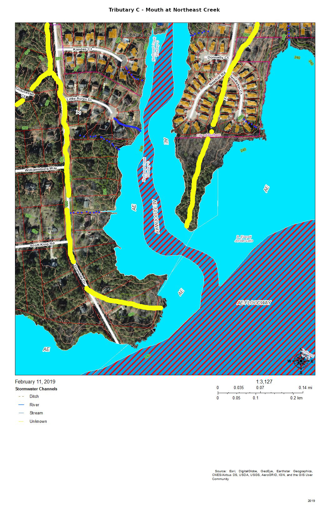
The mouth of Tributary C is a wetland flood plain that cycles between swamp forest in drier times and then snags (dead trees that are habitat for wildlife) and freshwater marsh in wetter times. You can see this same sort of landscape on the north side of NC 54 by Woodcroft Shopping Center.
Runoff from the roofs and drives flows through the yards or down the streets to the cul-de-sacs and down slopes into the bottomlands.
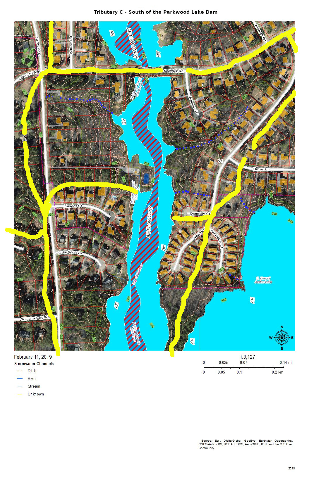
The main stream south of Parkwood Lake comes down the spillways from the lake through woods, under Sedwick Road, and into the bottomlands. An intermittent stream drains the runoff from the houses on Dedmon Court, Donnelly Court, Newhall Road, and Sedwick Road. An intermittent stream on the west side of the bottomlands drains the runoff from two houses on Sedwick Road and one on Grandale Road.
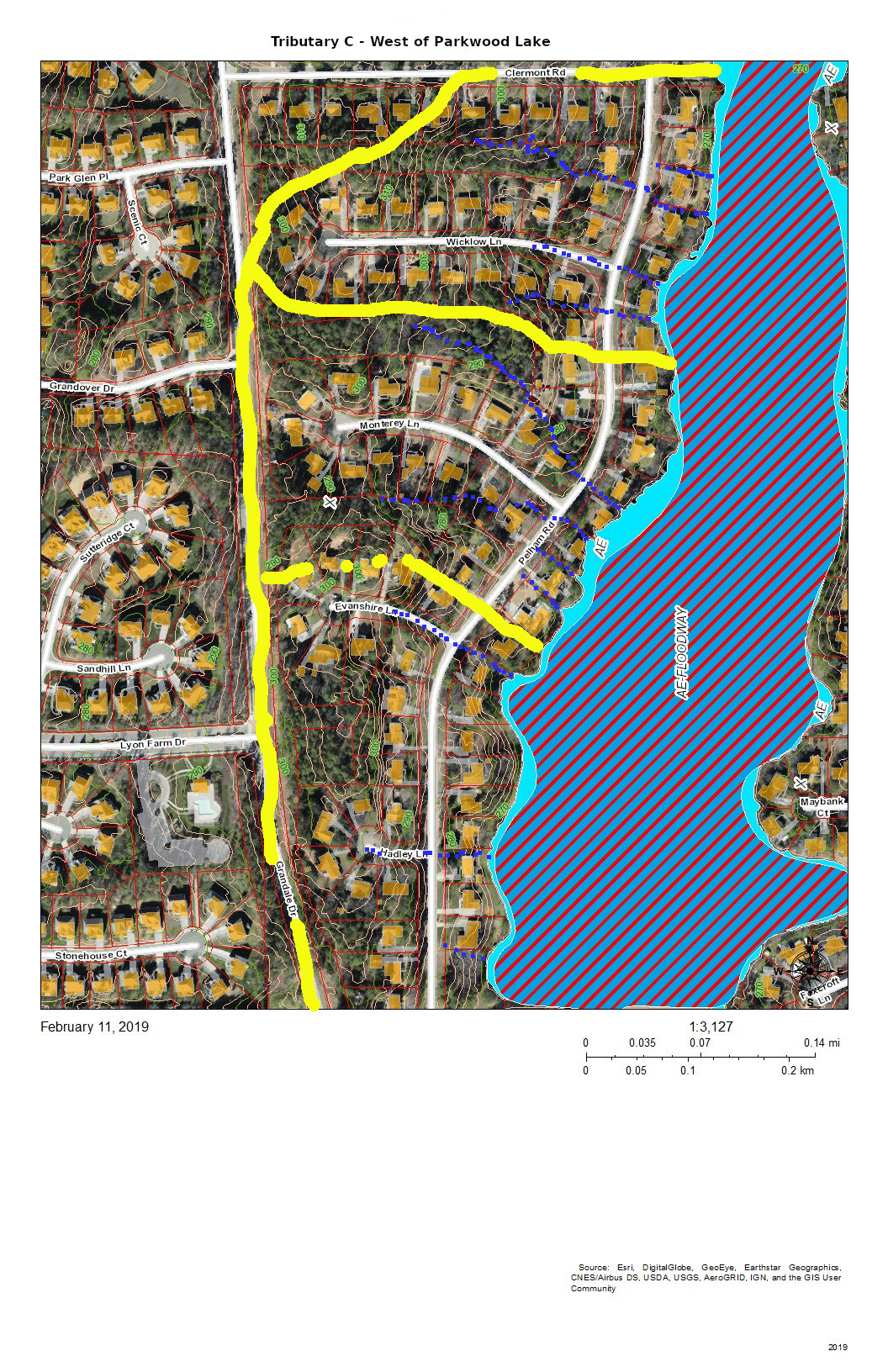
The runoff from the houses on the west side of Parkwood Lake primarily flows down the streets, across Pelham Road and into the lake. The runoff from the houses on lake flows directly into the lake.
The runoff from the east side of Grandale Road just north of Sedwick Road is directed into the ditch on the north side of Sedwick Road and is a part of this section of Tributary C.
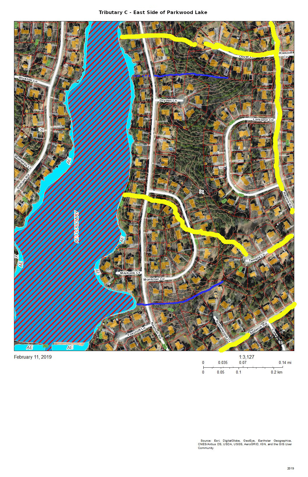
The east side of Parkwood Lake drains the west side of Revere Road and Larkspur Circle in addition to the houses along Newhall Road and the lakefront houses. There seem to be two more-or-less permanent streams draining from either corner of Larkspur Circle. There is significant Parkwood common land in the center of this block that aids in soaking up rainfall from Larkspur Circle and Revere Road. Another stream drains Temple Lane and Buttonwood Court.
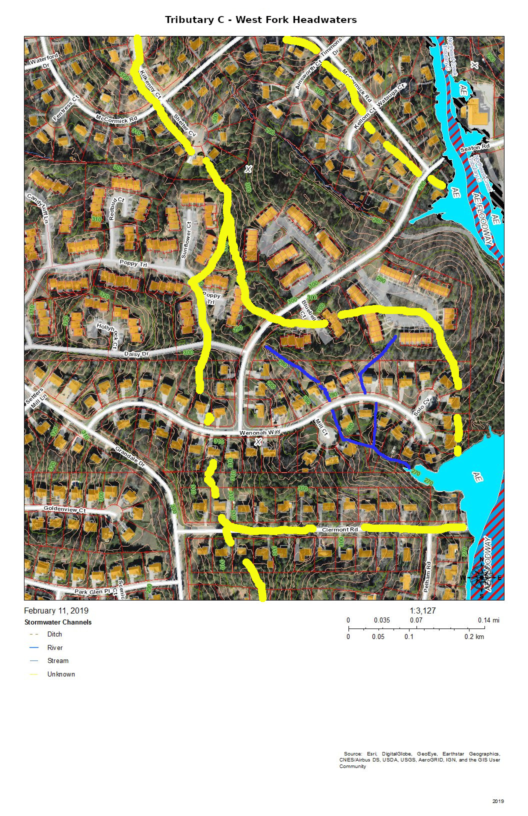
The west fork headwaters drain part of The Ridges of Parkwood, part of Parkwood Village, and some of the houses on Wenonah Way, Runoff from the west fork headwaters flow directly into the Parkwood Lake forebay (former lotus pond).
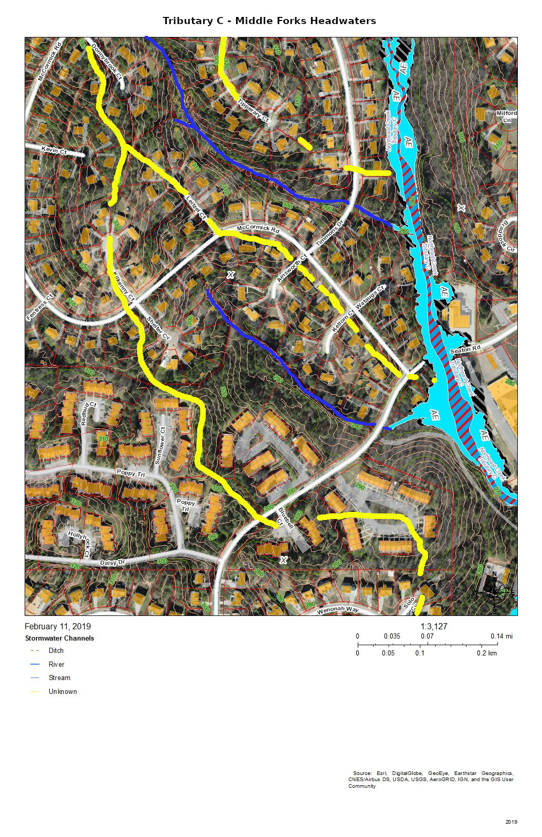
The headwaters of the two middle forks of Tributary C drain the southeast side of the McCormick Road highland. The southernmost of the two middle forks drains most of Parkwood Village.
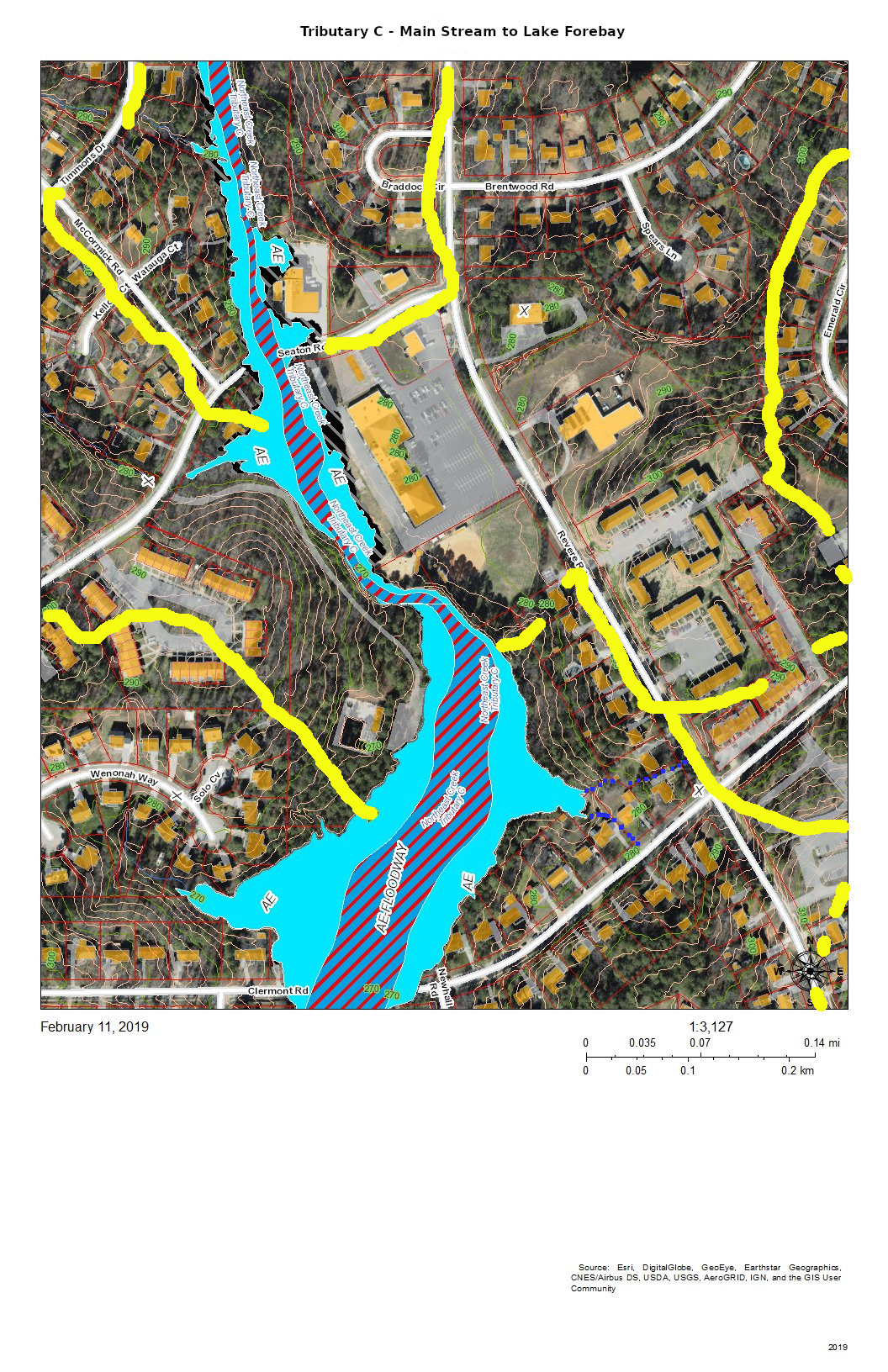
This section of Tributary C shows the main stream in the area of the trail from the Parkwood ballfield to the Parkwood Lake forebay (former lotus pond). The lower section is a significant bottomland that has a variety of interesting native plants such as magnolia, red maple, and native honeysuckle with hearts-a-bustin’, pussytoes, wild oregano, and lyre-leaf sage in the uplands.

The area of Tributary C east of Revere Road mostly drains through stormwater pipes the run under the parking lot of Jamaat Ibad Ar-Rahman mosque (former Parkwood Shopping Center). The stormwater pipes converge and empty through a single pipe outlet to Tributary C opposite Parkwood Village’s road to its swimming pool (the Pool in the Woods). This area drains from the hill on Brentwood Road near Bradley Circle and an area north of Brentwood Road almost to Travis Circle. It also drains the slope behind Parkwood United Methodist Church and the apartments up to the parcel that was set aside in the original design for a water tower and conveyed in that designation to the Parkwood Association. (In 1961, there were no city water and sewer services this far out. The Parkwood subdivision had a private utility that provided water from wells and owned and operated the package sewage plants.)
This elaborate stormwater system is the legacy of the philosophy of controlling stormwater that was prevalent at the beginning of the 1960s — pipe it away. The site preparation for “Parkwood Center”, the commercial and institutional core of the community froze some of the original stream system into the landscape while concentrating the flow under parking lots into a single stream. The object was to dump the excess water as fast as possible into Tributary C. After almost sixty years we can see that that strategy leads to stream scour and transportation of soil down the creek system. And creates erosional undercutting of the stream bank opposite the single stormwater pipe outlet.
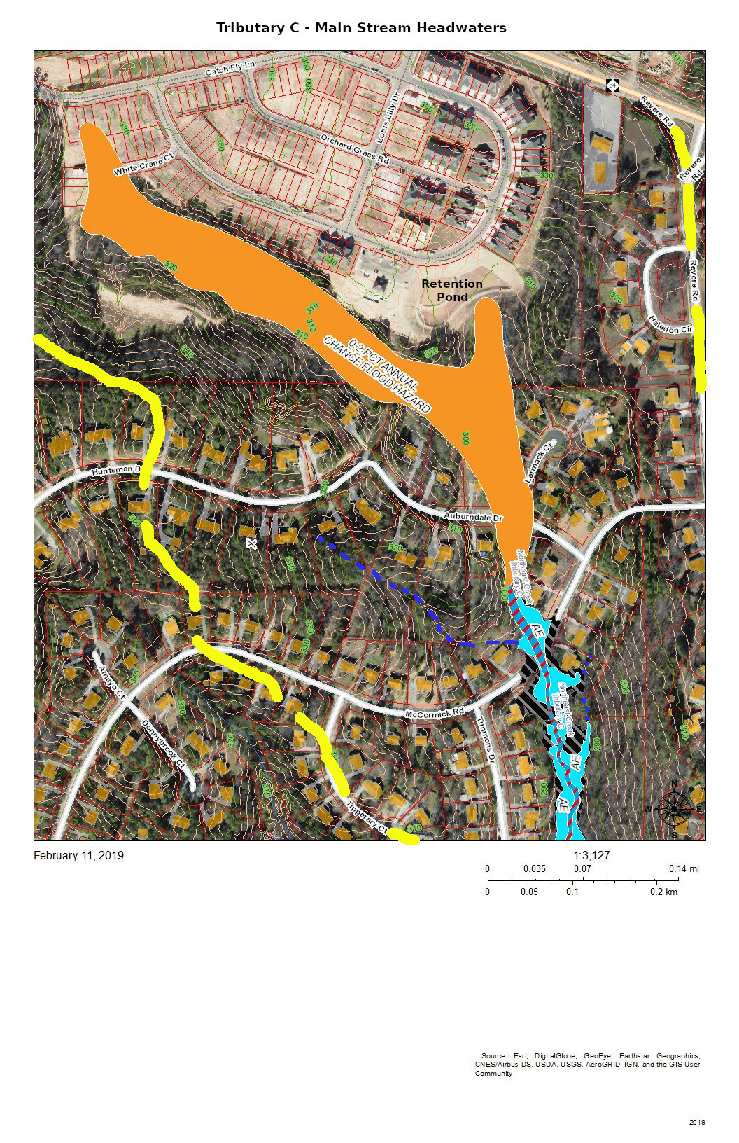
The headwaters of Tributary C lie completely south of NC 54 because NC 54 was built on a ridge between two tributaries of Northeast Creek and because subsequent engineering of the highway has sharpened the separations of the drainage. The headwaters now are developed as the Meadows at Southpoint, a town home community that uses regulation-permitted retention ponds instead of open space to manage run-off from its newly constructed houses, driveways, sidewalks, roads, and other impervious surfaces.
During construction, the Parkwood community experienced the fact that regulations are based on normal patterns of rainfall for construction of retention ponds. When there was a pattern of heavy rainfall, the retention ponds released sediments, particularly colloidial clay, into Tributary C; that turned the Parkwood Lake brown.
Residents in the Auburndale Drive-Lamarck Court area were among the first to notice the sediments because they monitor their nearby creeks.
In principle, with the completion of construction, the permanent retention ponds will prevent a recurrence. Continued citizen monitoring of their local creeks is the principal way of catching these situations early enough. And this is true for all of the streams draining into Northeast Creek.
That is why Northeast Creek Streamwatch is encouraging Upstream Neighbors/Downstream Neighbors, a volunteer program of monitoring neighborhood streams and conservation on your own property to harvest rainwater, conserve topsoil, and absorb water during abnormal rainfall.
Having attention on the portion of water flow from your house to the nearest creek is a critical part of what gets sent downstream.
Tributary D of Northeast Creek: Where does your water go?
Creek Week is coming March 13 through 20. During that week Durham is focusing attention on how individual citizens and property owners can with modest efforts deliver significant benefits to the quality of water moving downstream, especially to Jordan Lake.
A fun activity during Creek Week is to find the path that water from your roof, sidewalk, driveway, and patio or deck takes as it goes to Northeast Creek, down Northeast Creek and into Jordan Lake, and down the Cape Fear River to Wilmington.
To do that, we must perceive streams and their tributary flows of runoff (the water) in the foreground and land in the background. Focusing on the flash flood zones at full flood (the flood zones identified on the maps) shows the land as necks extending into the fully flooded lake headwaters. After all, one of the primary purposes of Lake Jordan was mitigation of the flash flooding that often occurred in the Haw River and New Hope Creek basins.
The coloring of the flood zones represent the following:
- Solid blue: 1% annual chance flood hazard
- Blue with red diagonal stripes: Regulatory floodway
- Gold: 0.2% annual chance flood hazard
- Black with gray diagonal stripes: Future conditions 1% annual chance flood hazard.
A previous post showed that Parkwood comprises parts of three sub-basins:
- The main stream of Northeast Creek on the east;
- Tributary C feeding Parkwood Lake in the center;
- Tributary D draining the western part of the McCormick high land and streams from Hunters Woods joining and running down Wineberry to the west.
This post presents maps to help find the path that the water takes from the roof of a particular house to Tributary D of Northeast Creek, which feeds the Parkwood Lake. Future posts will look at the main stream of Northeast Creek.
Here is an overview of Tributary D:
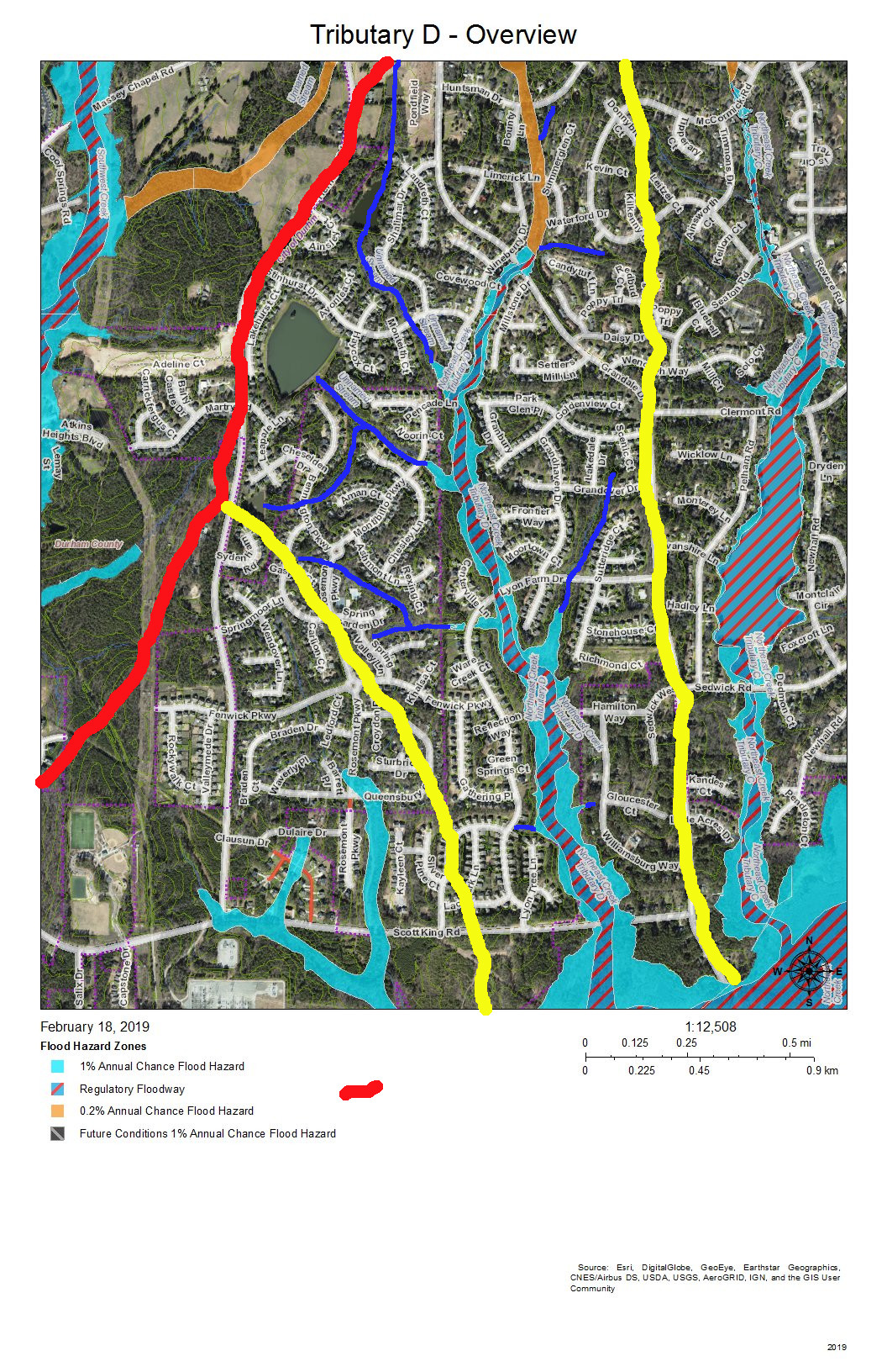
On this map, the red line is the boundary with the Crooked Creek basin. The yellow lines mark the sub-basin of the west fork of Tributary D and the dividing ridge along Grandale that separates Tributary D from Tributary C.
Skim through the maps to the part of Tributary D that you want to examine and then click on the map to enlarge. The sections with streams with blue solid or dotted lines are the section of Tributary D that for which the map is a guide, To enlarge further use the + keys in your viewer or Ctrl-+ on the keyboard. There will be some street references in the text following each map.
Yellow lines mark the sub-basins of Tributary D. Blue lines are the creeks in the area in the map title. Dotted blue lines are intermittent creeks inferred from the topography or known significant stormwater pipes. The impervious surfaces of roofs are orange within the City of Durham, and the impervious surfaces of parking lots, driveways, and other concrete structures are gray, also within the City of Durham. Outside the City of Durham in Durham County, with the image enlarged enough you can generally understand where roofs, driveways and sidewalks are.
Looking from the mouth of Tributary D and Northeast Creek, the sequence of maps examines each upstream branch and the main stream of Tributary D back to its source near the pond in Hunters Woods.
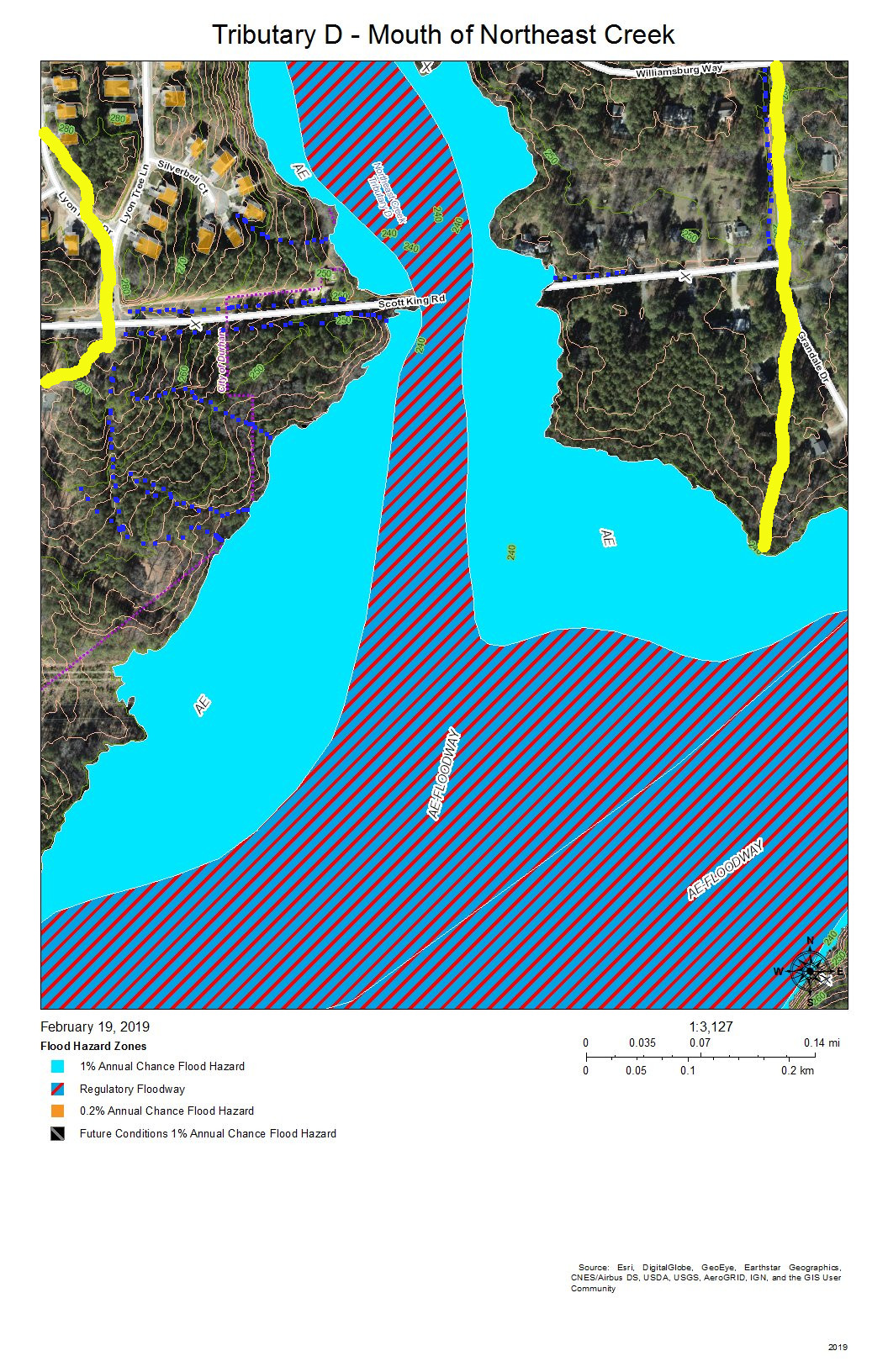
Almost all of the section floodway of Tributary D in this map of the map is in US Army Corps of Engineers land surrounding the headwaters of Lake Jordan. This property does extend north of Scott King Road.
The drainage channels shown on this map are primarily intermittent streams that flow down the swales on either side of Scott King Road and intermittent streams flowing down slopes into Tributary D.
This is an area in which we have cleaned out tires from Corps of Engineers property in past clean-ups.
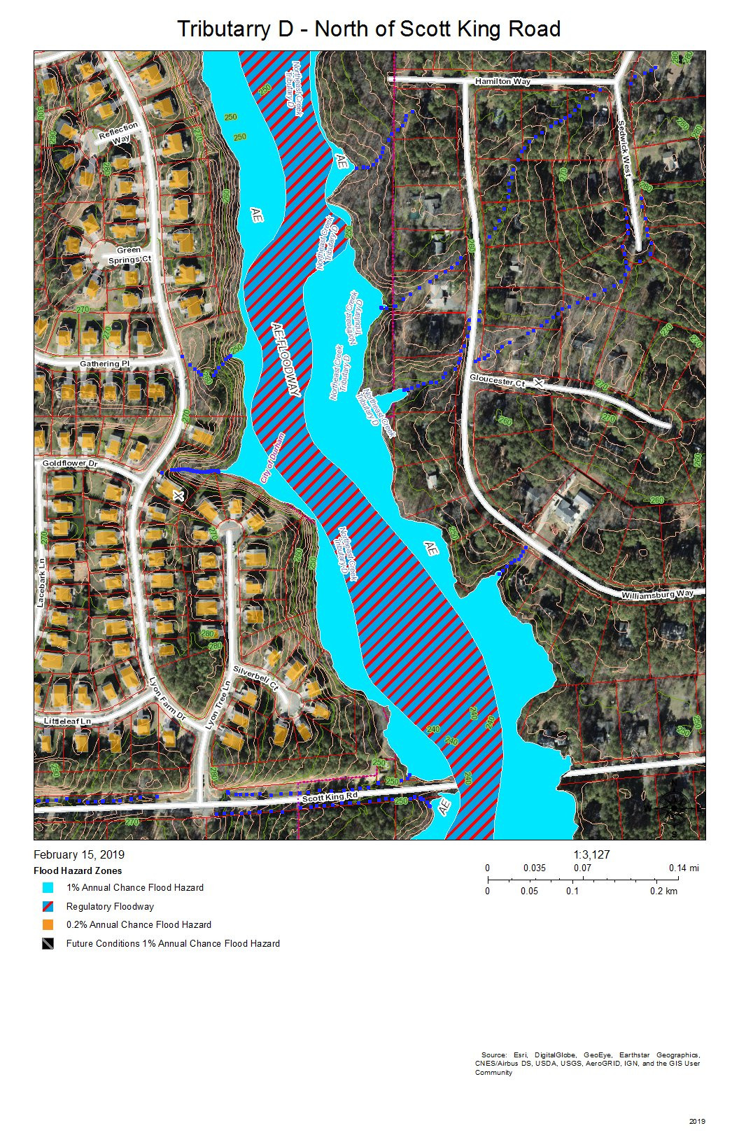
This section of Tributary D is between Lyons Farm on the west and Lake Park on the East. Most of the drainage is from runoff down the slopes, from stormwater pipes not shown on this map, or from the intermittent streams at various points on the stream bank.
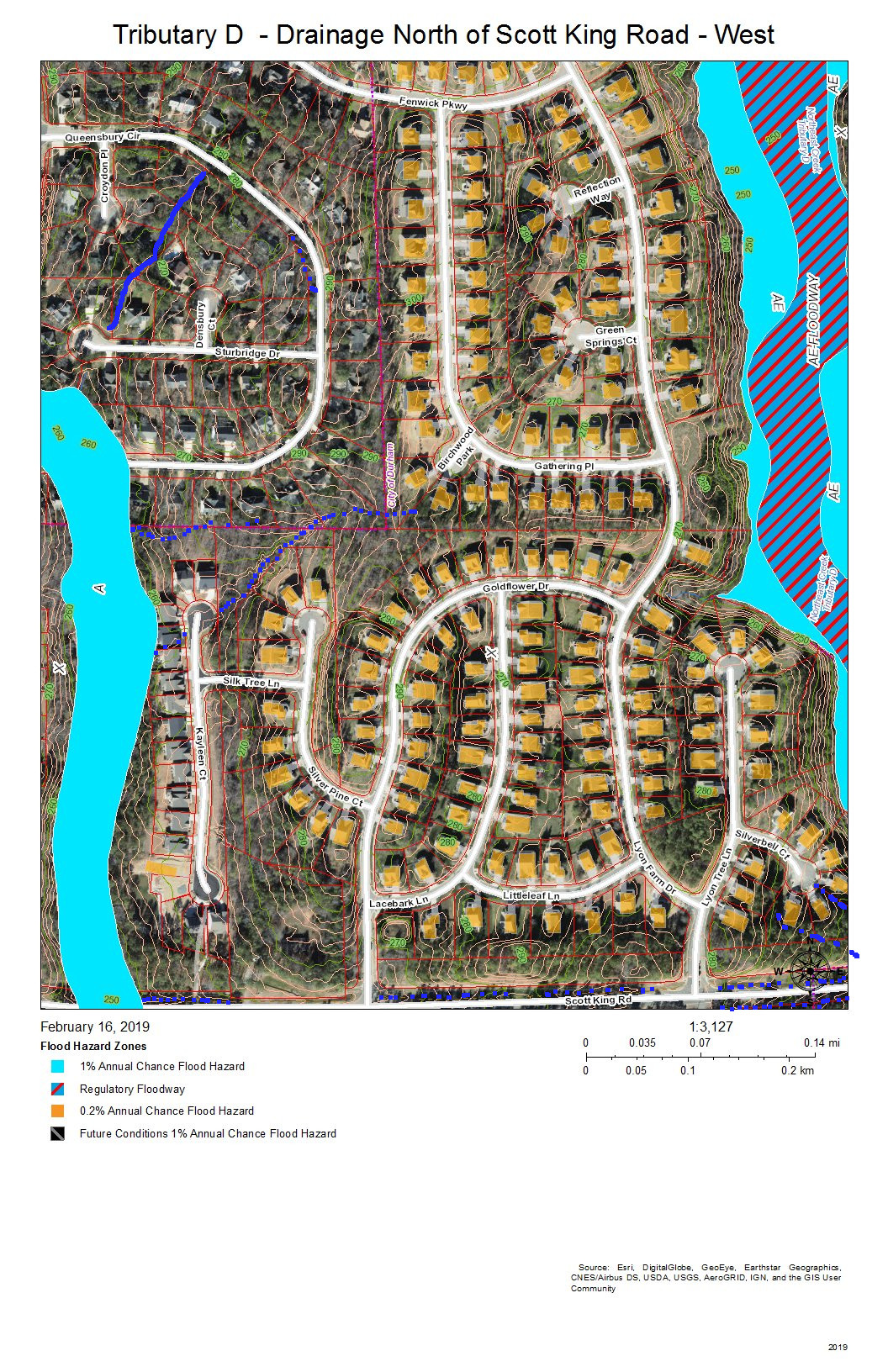
Fairfield, Grandale, and Lyons Farm are the neighborhoods between Tributary D on the east and a fork of Tributary D on the west that crosses Scott King Road just west of Goldflower Drive and joins the Tributary D wetland in Corps land.
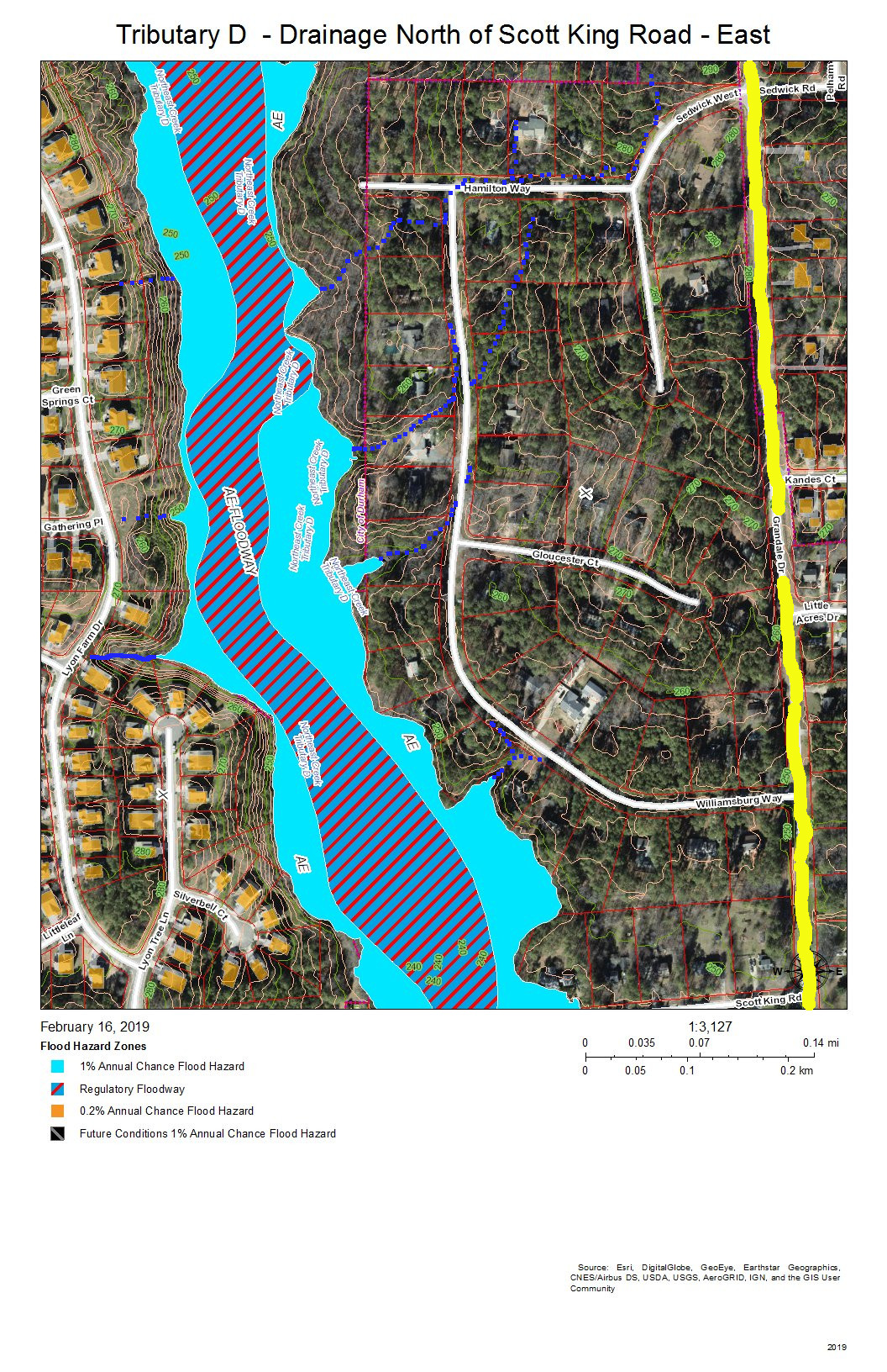
Lake Park is the neighborhood on the east bank of Tributary C north of Scott King Road. Drainage is from intermittent streams or stormwater pipes not shown on this map.
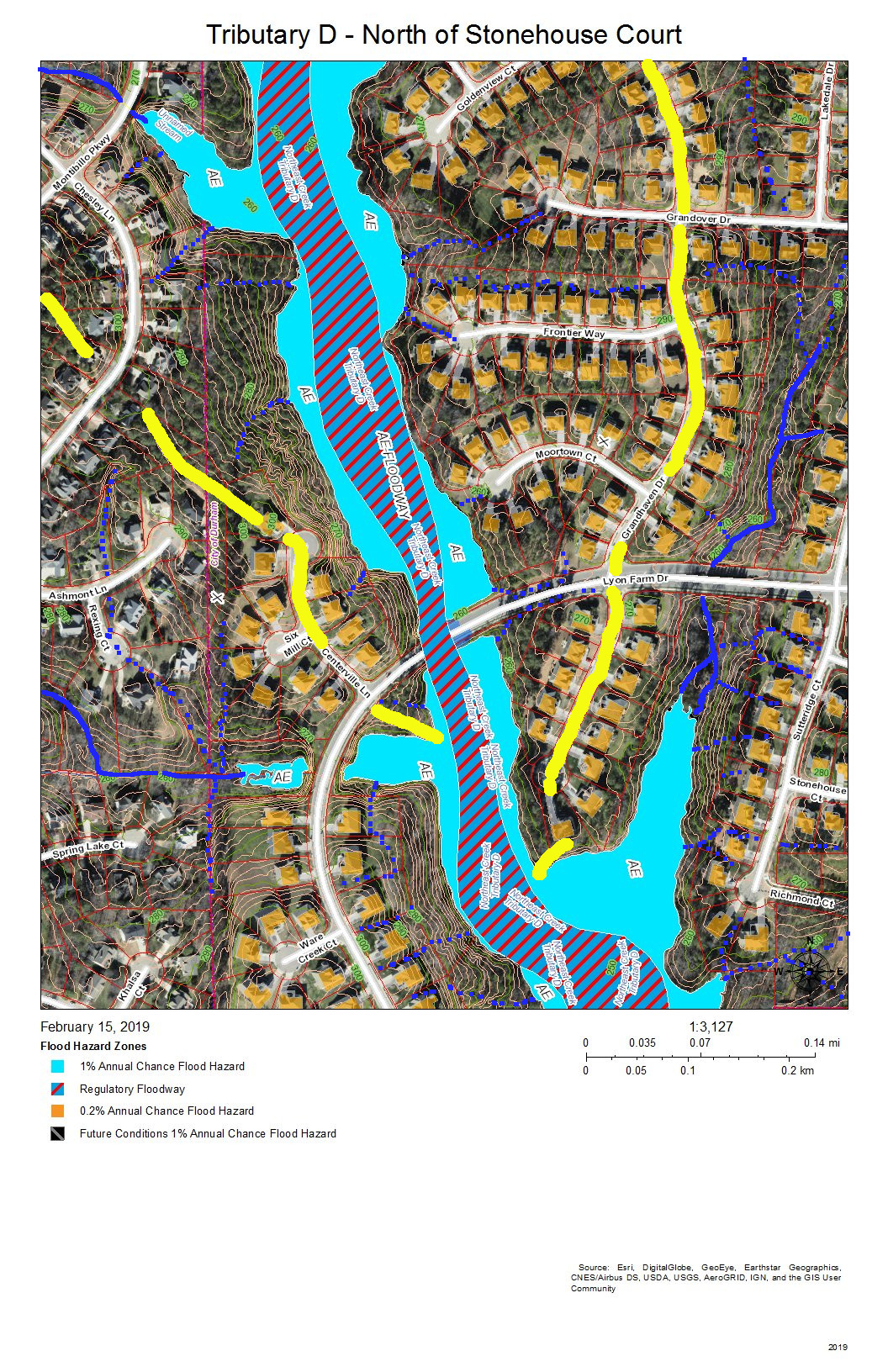
Fairfield, Grandale, and Grandale Place are the neighborhoods where the main stream of Tributary D meets some of its own tributaries.
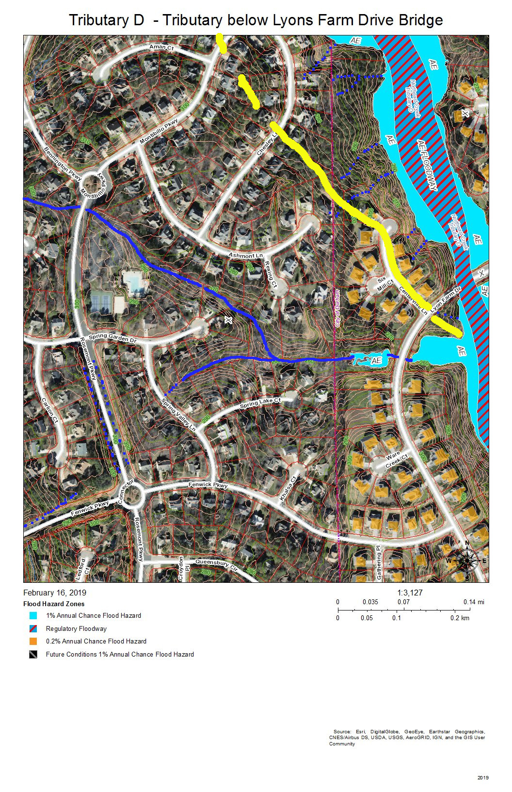
Fairfield and Grandale are the neighborhoods on this section of Tributary D. A tributary stream crosses under Rosemont Parkway just south of the circle on Montibillo Parkway. The yellow line marks the watershed ridge separating the main stream of Tributary D from this tributary.
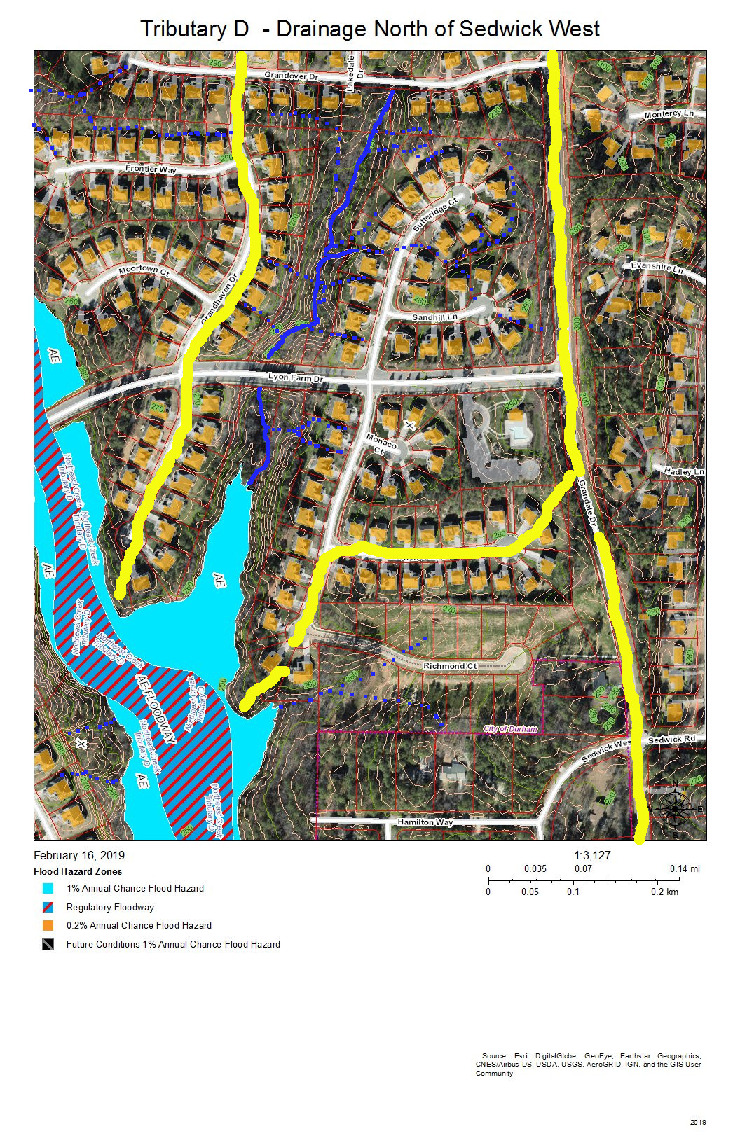
Grandale is the neighborhood in this view, and the neighborhood building at the entrance from Grandale Drive is the one with the L-shaped parking lot. The yellow line along Grandale marks the watershed ridge with Tributary C. The other yellow lines outline the sub-basin of the tributary from Grandover Drive that joins the main stream of Tributary D in this view. Other drainage is from intermittent stream (dotted blue lines) or stormwater pipes not visible on this map.
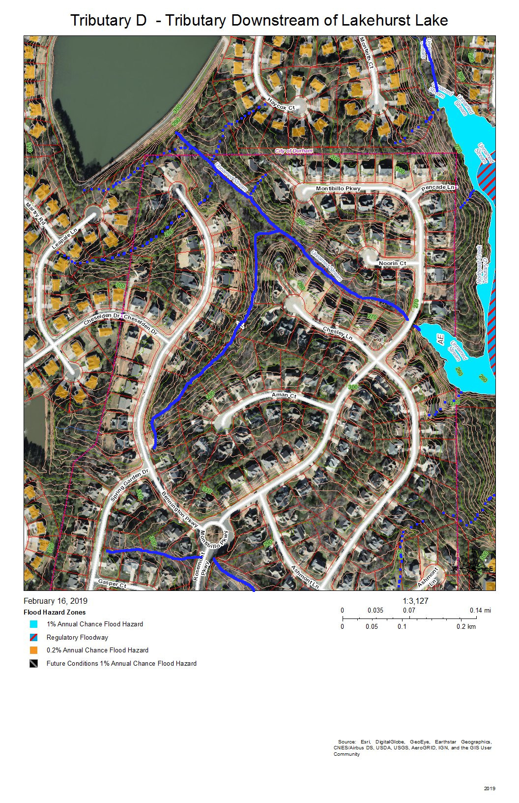
Fairfield and Lakehurst are the neighborhoods in this view. The lake in the Lakehurst neighborhood dams the tributary that flows into Tributary D and that acts somewhat like a retention pond moderating wet and dry weather patterns. Elsewhere, intermittent streams and stormwater pipes not visible on this map drain the runoff from development into the tributary streams.
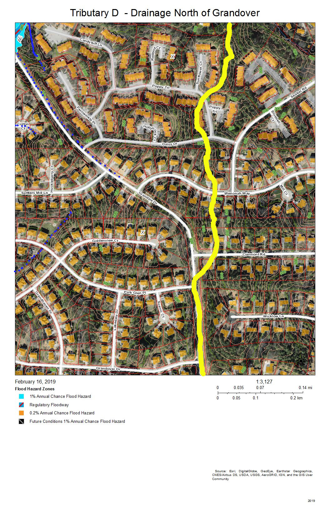
Grandale Place, Settlers Mill, and the Ridges at Parkwood are the neighborhoods in this view. The drainage flows through stormwater pipes not visible on the map and down intermittent streams (marked with blue dots).
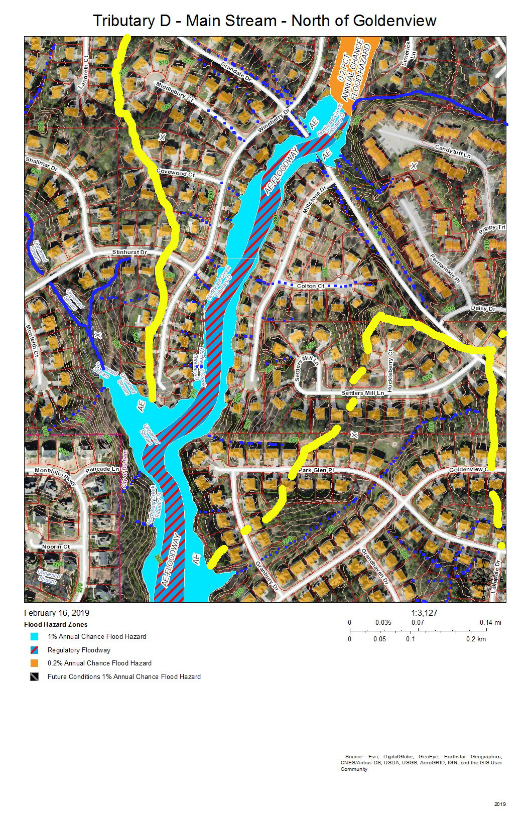
Grandale Place, Settlers Mill, Grandale Forest, and Lakehurst are the neighborhoods in this view. The yellow line at the top is the watershed ridge separating the fork that drains north of Stinhurst Drive from the main stream. The other yellow line shows the sub-basin of the tributary intermittent streams that drain Grandale Place; this might be supplemented with stormwater pipes not shown on this map.
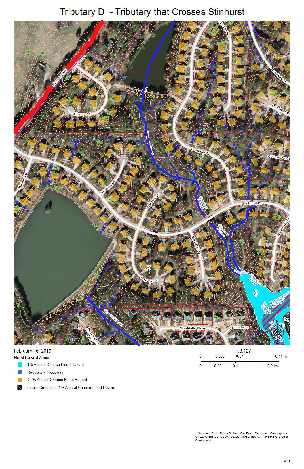
Lakehurst Pointe and Lakehurst are the neighborhoods in this view. The red line shows the watershed ridge between the Northeast Creek basin and the Crooked Creek basin. Two tributaries of Tributary D join the main stream beyond the cul-de-sac at the end of Wineberry Drive. One of these originates above the lake in Lakehurst Pointe; the other originates between the cul-de-sacs of Landreth Court and Middlebury Court in Lakehurst Pointe.
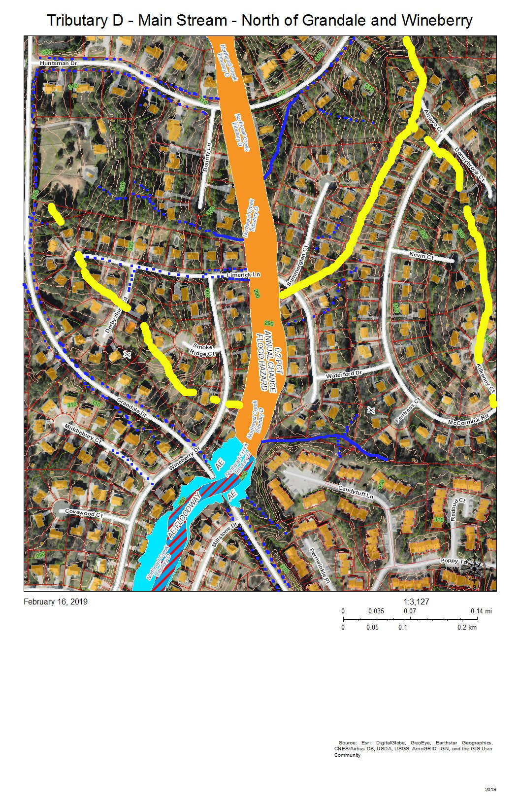
Grandale Forest and Parkwood are the neighborhoods in this view. The intersection of Grandale Drive and Wineberry Drive are the point at which a tributary from the southwestern section of McCormick Road, an intermittent creek from the Ridges, and the intermittent creeks that flow down the swales on either side of Grandale Drive merge before crossing through two 4-foot pipes under Grandale Drive and flowing behind the houses on Wineberry Drive. Over 20 years, the section of creek along Wineberry Drive has scoured almost four feet of depth in the streambed, and water still overflows into yards in heavy rains.
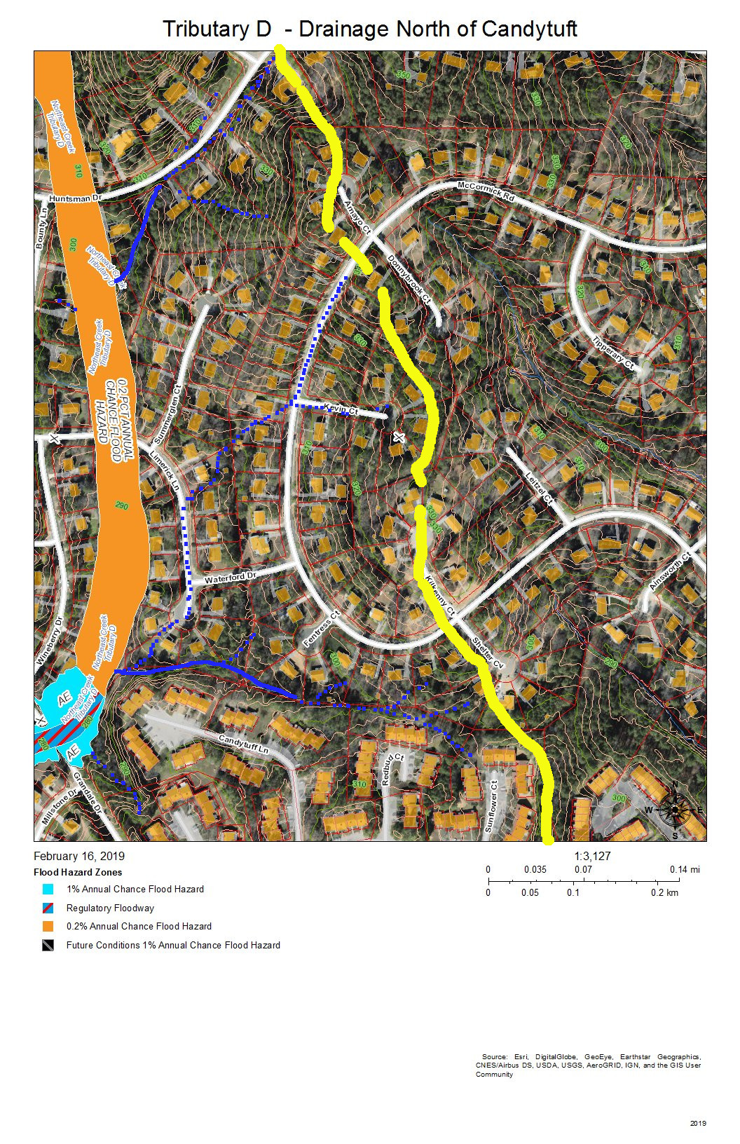
The Ridges of Parkwood, Parkwood, and Hunters Woods are the neighborhoods in this view. The yellow line marks the watershed ridge between Tributary D and Tributary C. Two tributary streams drain this area–one south of Huntsman Drive and one north of Candytuft Lane. An intermittent stream drains the west side of the McCormick highlands and flows down McCormick Road. Another intermittent stream flows down Limerick Lane.
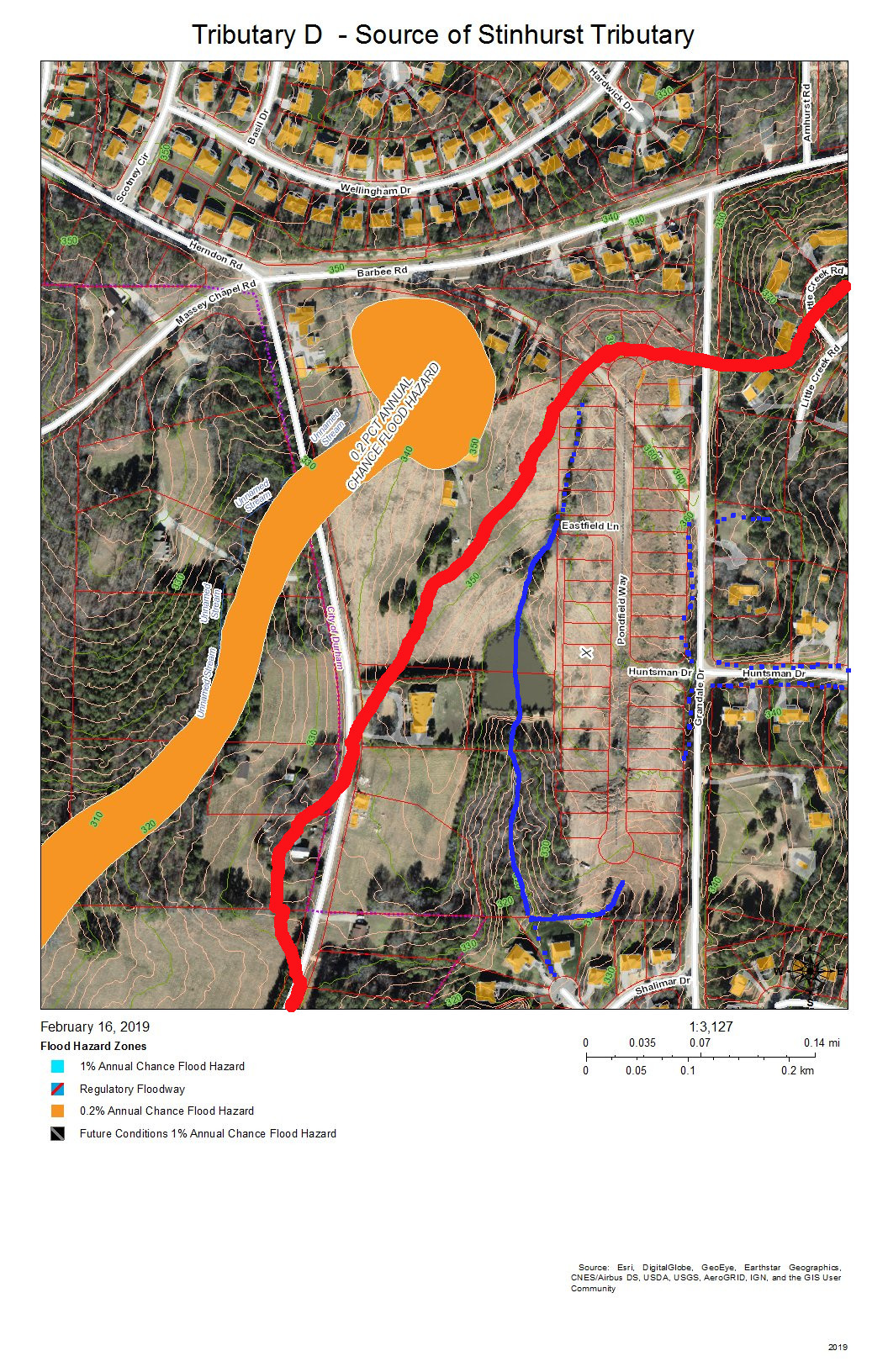
Lakehurst Pointe and Grandin Trace are the neighborhoods in this view. The red line is the boundary between Tributary D and the Crooked Creek basin. The source is in what is soon to be the northwest corner of Grandin Trace and flows into a pond that releases a stream that flows openly and then through stormpipes into the lake in Lakehurst Pointe.
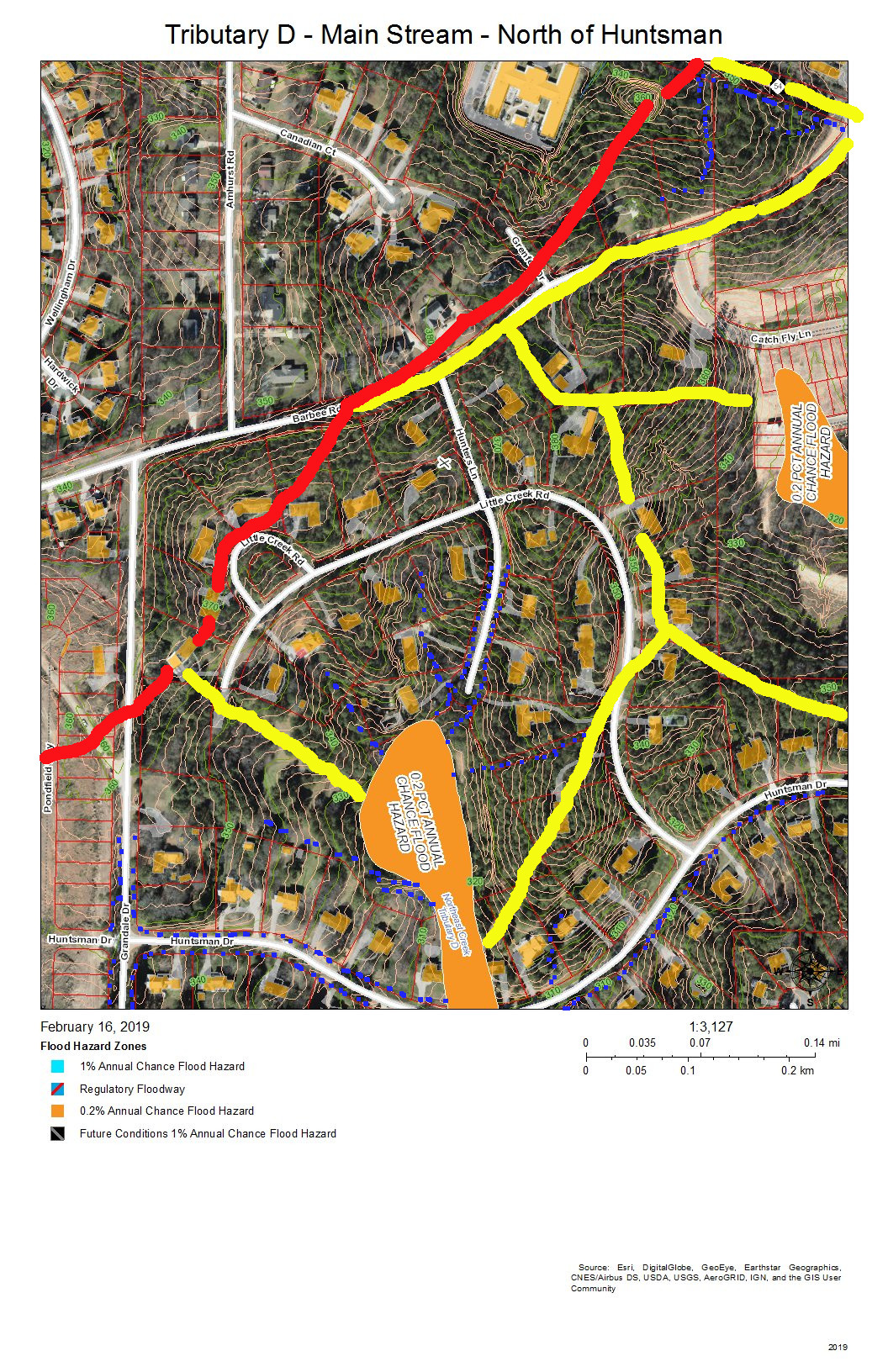
Hunters Woods is the neighborhood in this view. The yellow lines on the east are two sub-basins of tributaries of Tributary C that drain the Meadows at Southpoint. The red line is the watershed ridge between Crooked Creek and Northeast Creek. The yellow line along Barbee Road is the drainage off of Barbee Road that road construction has shifted from the Northeast Creek basin to the Crooked Creek basin. A local high point (elevation over 380 feet) was the site of a NC Forest Service fire tower until shortly before Hunters Wood was developed. This high point allow a ranger to see many square miles of woodlands cultivated on the uplands and bottomlands of Northeast Creek and Crooked Creek.

Parkwood and Hunters Woods are the neighborhoods in this view. The yellow line marks the watershed ridge between Tributary D and Tributary C. The orange in Tributary C is the 0.2 percent chance flood zone in the headwaters of the Meadows at Southpoint retention pond. The orange in Tributary D is the Hunters Woods lake and the overflow path if the dam is topped; this is also a 0.2 percent chance flood zone.
All of the maps in this series are works in progress that need investigation by residents of the neighborhoods reporting what they see on the ground. There are many points that are not clear from aerial views about how the drainage flows. One issue in particular is how the retention pond from Grandin Trace flows into the lake in Lakehurst Pointe. As we get corrections we can edit the maps to apply them and eventually have maps to provide an atlas of the Tributary D basin.
Send corrections to colleen@northeastcreek.org.