Creek Week is coming March 13 through 20. During that week Durham is focusing attention on how individual citizens and property owners can with modest efforts deliver significant benefits to the quality of water moving downstream, especially to Jordan Lake.
A fun activity during Creek Week is to find the path that water from your roof, sidewalk, driveway, and patio or deck takes as it goes to Northeast Creek, down Northeast Creek and into Jordan Lake, and down the Cape Fear River to Wilmington.
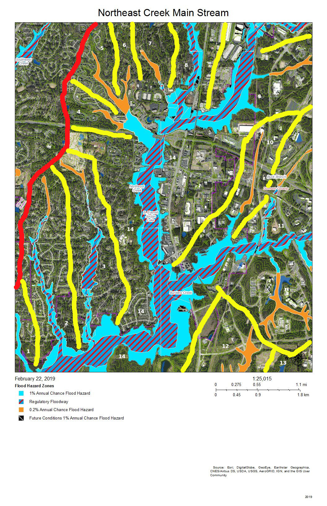
To do that, we must perceive streams and their tributary flows of runoff (the water) in the foreground and land in the background. Focusing on the flash flood zones at full flood (the flood zones identified on the maps) shows the land as necks extending into the fully flooded lake headwaters. After all, one of the primary purposes of Lake Jordan was mitigation of the flash flooding that often occurred in the Haw River and New Hope Creek basins.
The coloring of the flood zones represent the following:
Solid blue: 1% annual chance flood hazard
Blue with red diagonal stripes: Regulatory floodway
Gold: 0.2% annual chance flood hazard
Black with gray diagonal stripes: Future conditions 1% annual chance flood hazard.
A previous post showed that Parkwood comprises parts of three sub-basins:
The main stream of Northeast Creek on the east;
Tributary C feeding Parkwood Lake in the center;
Tributary D draining the western part of the McCormick high land and streams from Hunters Woods joining and running down Wineberry to the west.
This post presents maps to help find the path that the water takes from the roof of a particular house to Tributary C of Northeast Creek, which feeds the Parkwood Lake. Future posts will look at Tributary D and the main stream of Northeast Creek.
Skim through the maps to the part of Tributary C that you want to examine and then click on the map to enlarge. To enlarge further use the + keys in your viewer or Ctrl-+ on the keyboard. There will be some street references in the text following each map.
Yellow lines mark the sub-basins of Tributary C. Blue lines are the creeks in the area in the map title. Dotted blue lines are intermittent creeks inferred from the topography or known significant stormwater pipes. The impervious surfaces of roofs are orange, and the impervious surfaces of parking lots, driveways, and other concrete structures are gray.
Looking from the mouth of Tributary C and Northeast Creek, the sequence of maps examines each upstream branch and the main stream of Tributary C back to its source near NC 54.
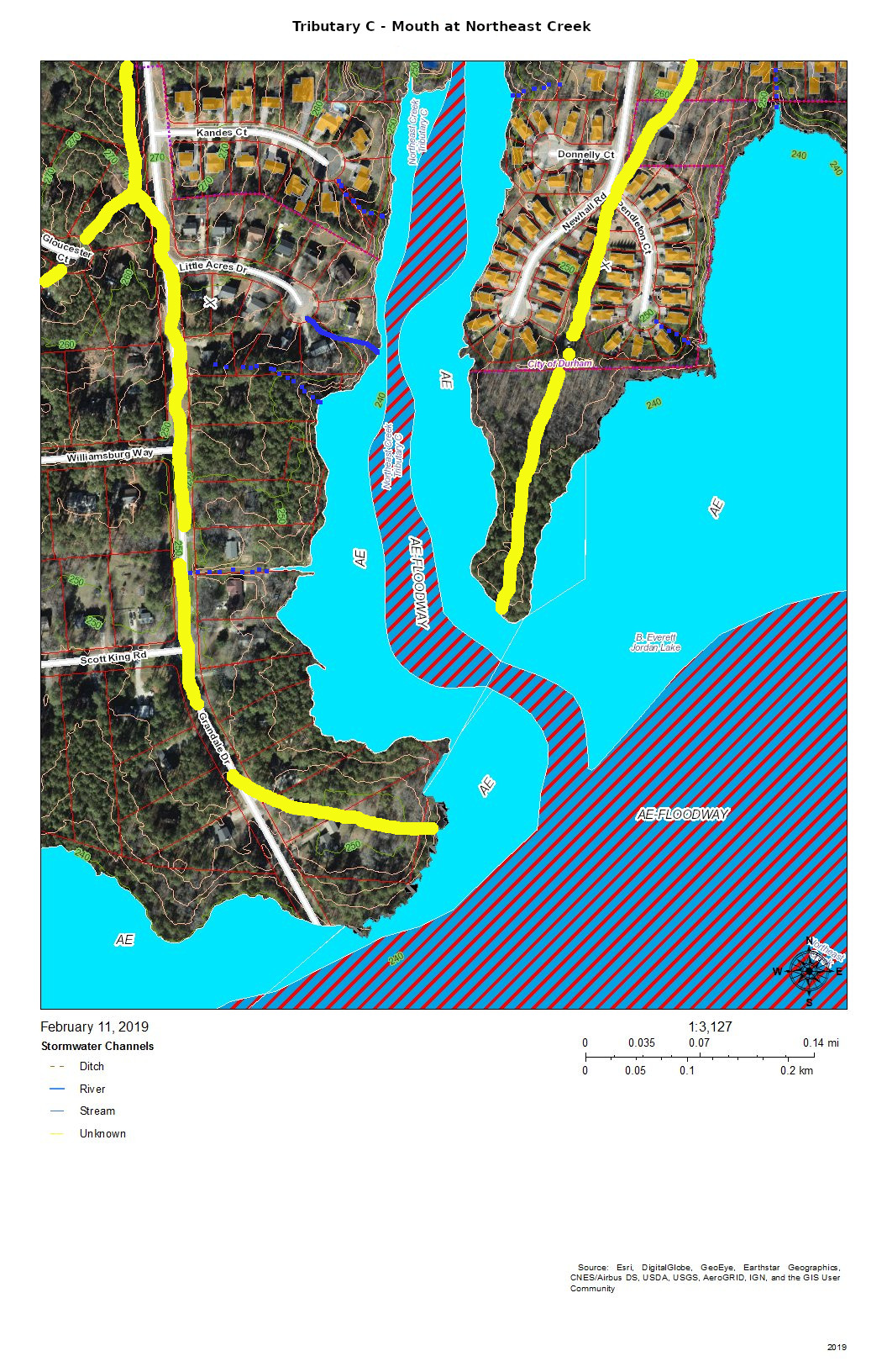
Mouth of Tributary C at Northeast Creek
The mouth of Tributary C is a wetland flood plain that cycles between swamp forest in drier times and then snags (dead trees that are habitat for wildlife) and freshwater marsh in wetter times. You can see this same sort of landscape on the north side of NC 54 by Woodcroft Shopping Center.
Runoff from the roofs and drives flows through the yards or down the streets to the cul-de-sacs and down slopes into the bottomlands.
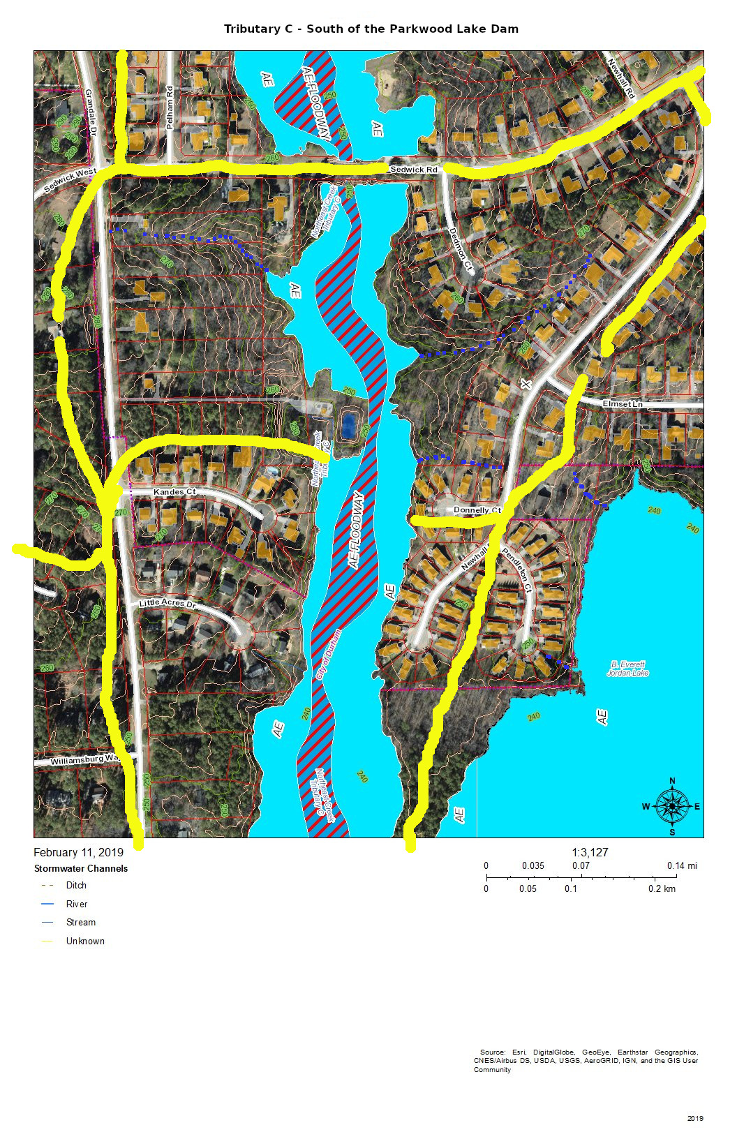
Tributary C South of the Parkwood Lake Dam
The main stream south of Parkwood Lake comes down the spillways from the lake through woods, under Sedwick Road, and into the bottomlands. An intermittent stream drains the runoff from the houses on Dedmon Court, Donnelly Court, Newhall Road, and Sedwick Road. An intermittent stream on the west side of the bottomlands drains the runoff from two houses on Sedwick Road and one on Grandale Road.
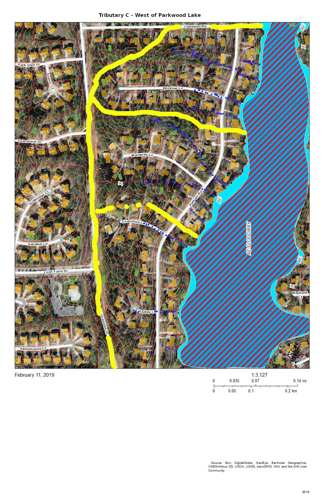
Tributary C as Parkwood Lake and the West Side Headwaters
The runoff from the houses on the west side of Parkwood Lake primarily flows down the streets, across Pelham Road and into the lake. The runoff from the houses on lake flows directly into the lake.
The runoff from the east side of Grandale Road just north of Sedwick Road is directed into the ditch on the north side of Sedwick Road and is a part of this section of Tributary C.
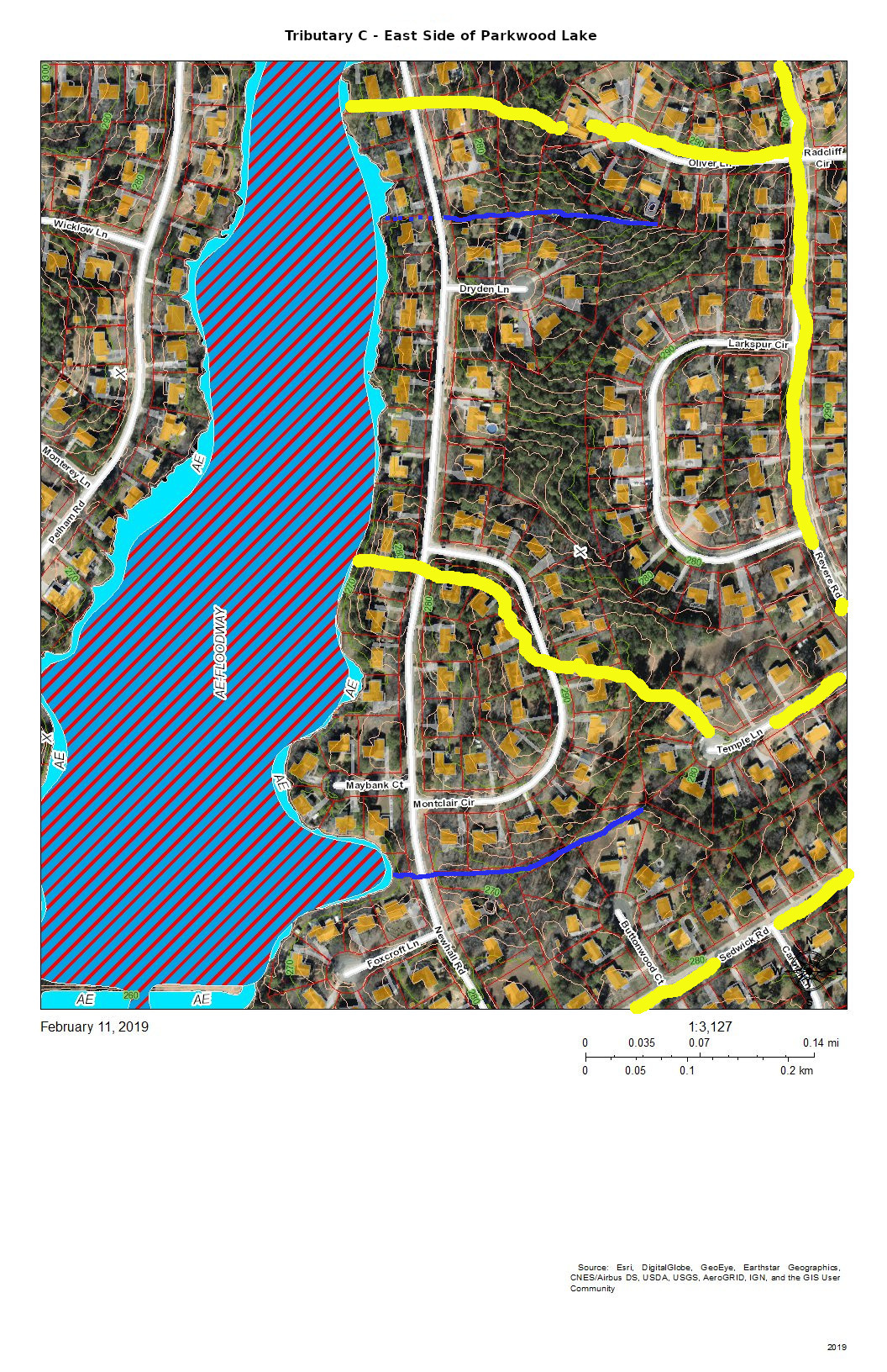
Tributary C – East Side of Parkwood Lake
The east side of Parkwood Lake drains the west side of Revere Road and Larkspur Circle in addition to the houses along Newhall Road and the lakefront houses. There seem to be two more-or-less permanent streams draining from either corner of Larkspur Circle. There is significant Parkwood common land in the center of this block that aids in soaking up rainfall from Larkspur Circle and Revere Road. Another stream drains Temple Lane and Buttonwood Court.
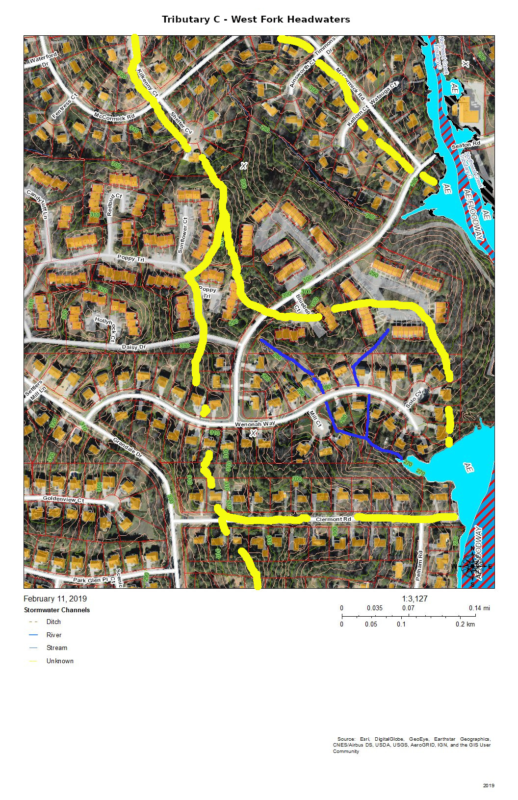
Tributary C West Fork Headwaters
The west fork headwaters drain part of The Ridges of Parkwood, part of Parkwood Village, and some of the houses on Wenonah Way, Runoff from the west fork headwaters flow directly into the Parkwood Lake forebay (former lotus pond).
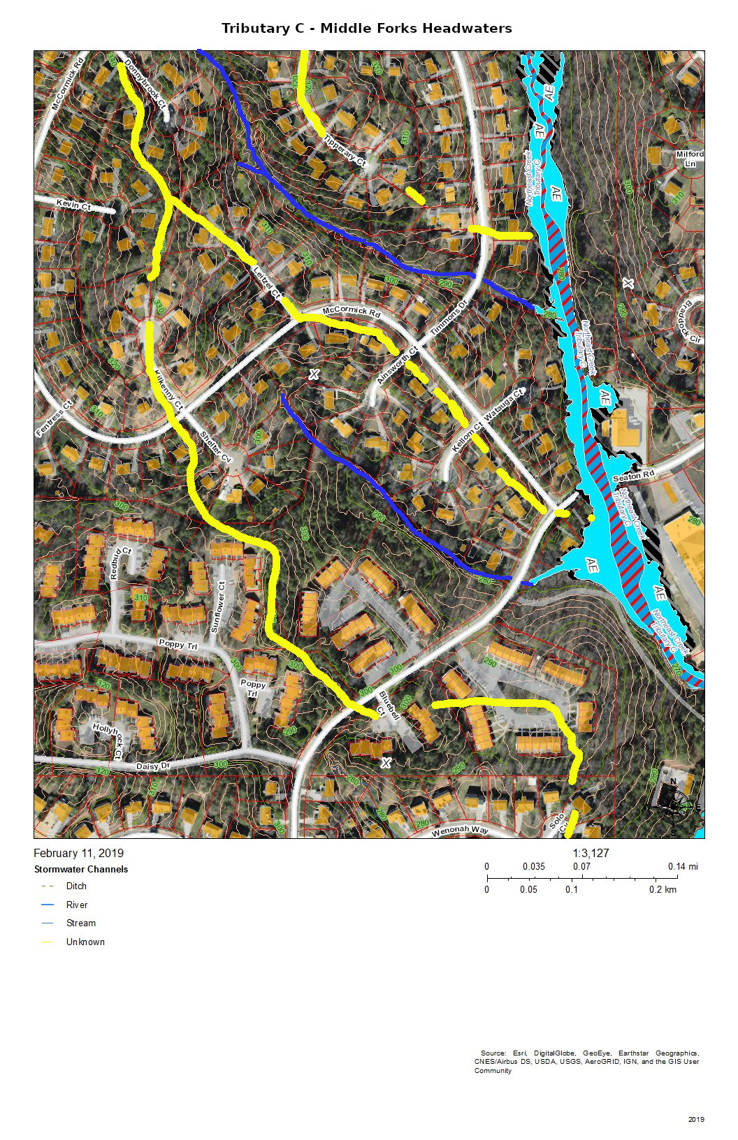
Tributary C – Middle Forks Headwaters
The headwaters of the two middle forks of Tributary C drain the southeast side of the McCormick Road highland. The southernmost of the two middle forks drains most of Parkwood Village.
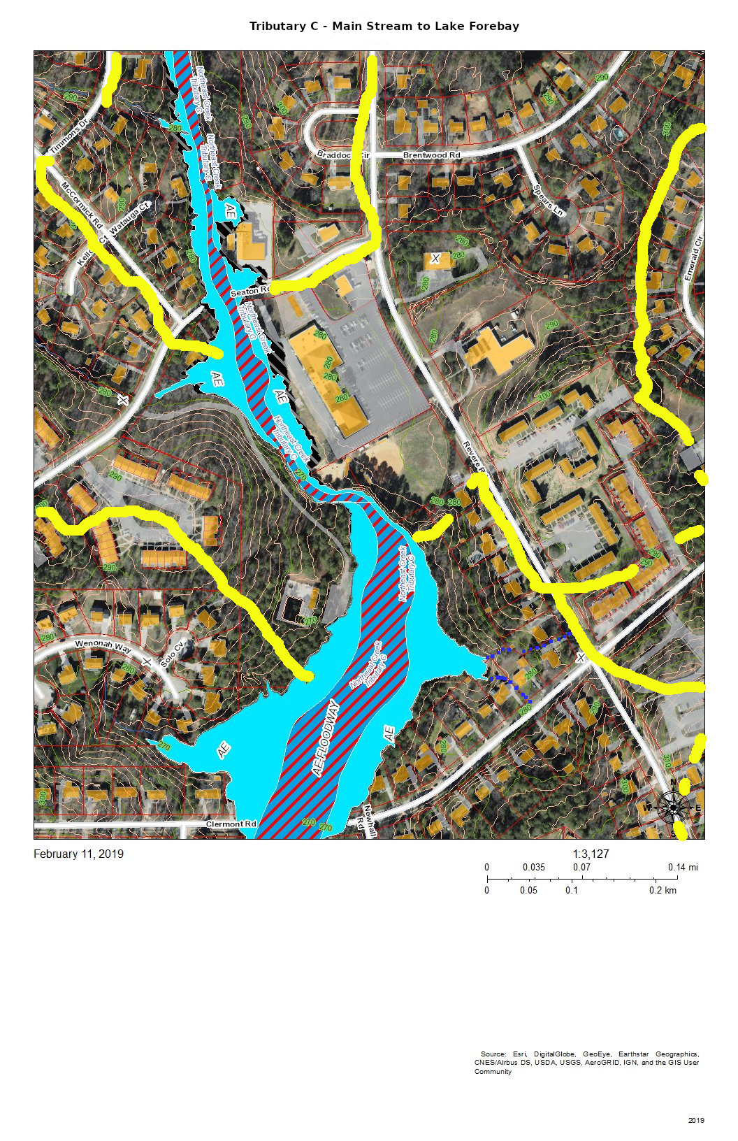
Tributary C – Main Stream to Lake Forebay (former Lotus Pond)
This section of Tributary C shows the main stream in the area of the trail from the Parkwood ballfield to the Parkwood Lake forebay (former lotus pond). The lower section is a significant bottomland that has a variety of interesting native plants such as magnolia, red maple, and native honeysuckle with hearts-a-bustin’, pussytoes, wild oregano, and lyre-leaf sage in the uplands.
Tributary C – Drainage from East of Revere Road
The area of Tributary C east of Revere Road mostly drains through stormwater pipes the run under the parking lot of Jamaat Ibad Ar-Rahman mosque (former Parkwood Shopping Center). The stormwater pipes converge and empty through a single pipe outlet to Tributary C opposite Parkwood Village’s road to its swimming pool (the Pool in the Woods). This area drains from the hill on Brentwood Road near Bradley Circle and an area north of Brentwood Road almost to Travis Circle. It also drains the slope behind Parkwood United Methodist Church and the apartments up to the parcel that was set aside in the original design for a water tower and conveyed in that designation to the Parkwood Association. (In 1961, there were no city water and sewer services this far out. The Parkwood subdivision had a private utility that provided water from wells and owned and operated the package sewage plants.)
This elaborate stormwater system is the legacy of the philosophy of controlling stormwater that was prevalent at the beginning of the 1960s — pipe it away. The site preparation for “Parkwood Center”, the commercial and institutional core of the community froze some of the original stream system into the landscape while concentrating the flow under parking lots into a single stream. The object was to dump the excess water as fast as possible into Tributary C. After almost sixty years we can see that that strategy leads to stream scour and transportation of soil down the creek system. And creates erosional undercutting of the stream bank opposite the single stormwater pipe outlet.
Tributary C – Headwaters of Main Stream
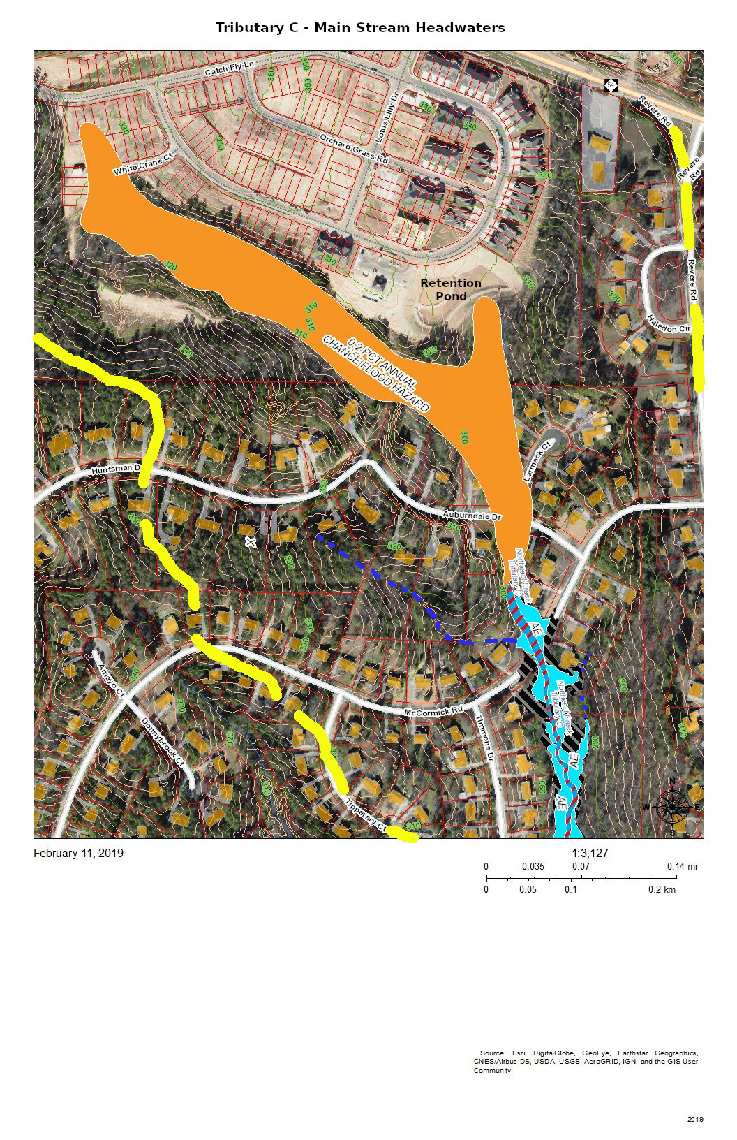
The headwaters of Tributary C lie completely south of NC 54 because NC 54 was built on a ridge between two tributaries of Northeast Creek and because subsequent engineering of the highway has sharpened the separations of the drainage. The headwaters now are developed as the Meadows at Southpoint, a town home community that uses regulation-permitted retention ponds instead of open space to manage run-off from its newly constructed houses, driveways, sidewalks, roads, and other impervious surfaces.
During construction, the Parkwood community experienced the fact that regulations are based on normal patterns of rainfall for construction of retention ponds. When there was a pattern of heavy rainfall, the retention ponds released sediments, particularly colloidial clay, into Tributary C; that turned the Parkwood Lake brown.
Residents in the Auburndale Drive-Lamarck Court area were among the first to notice the sediments because they monitor their nearby creeks.
In principle, with the completion of construction, the permanent retention ponds will prevent a recurrence. Continued citizen monitoring of their local creeks is the principal way of catching these situations early enough. And this is true for all of the streams draining into Northeast Creek.
That is why Northeast Creek Streamwatch is encouraging Upstream Neighbors/Downstream Neighbors, a volunteer program of monitoring neighborhood streams and conservation on your own property to harvest rainwater, conserve topsoil, and absorb water during abnormal rainfall.
Having attention on the portion of water flow from your house to the nearest creek is a critical part of what gets sent downstream.
Creek Week is coming March 13 through 20. During that week Durham is focusing attention on how individual citizens and property owners can with modest efforts deliver significant benefits to the quality of water moving downstream, especially to Jordan Lake.
A fun activity during Creek Week is to find the path that water from your roof, sidewalk, driveway, and patio or deck takes as it goes to Northeast Creek, down Northeast Creek and into Jordan Lake, and down the Cape Fear River to Wilmington.
To do that, we must perceive streams and their tributary flows of runoff (the water) in the foreground and land in the background. Focusing on the flash flood zones at full flood (the flood zones identified on the maps) shows the land as necks extending into the fully flooded lake headwaters. After all, one of the primary purposes of Lake Jordan was mitigation of the flash flooding that often occurred in the Haw River and New Hope Creek basins.
The coloring of the flood zones represent the following:
Solid blue: 1% annual chance flood hazard
Blue with red diagonal stripes: Regulatory floodway
Gold: 0.2% annual chance flood hazard
Black with gray diagonal stripes: Future conditions 1% annual chance flood hazard.
A previous post showed that Parkwood comprises parts of three sub-basins:
Tributary D draining the western part of the McCormick high land and streams from Hunters Woods joining and running down Wineberry to the west.
This post presents maps to help find the path that the water takes from the roof of a particular house to Tributary D of Northeast Creek, which feeds the Parkwood Lake. Future posts will look at the main stream of Northeast Creek.
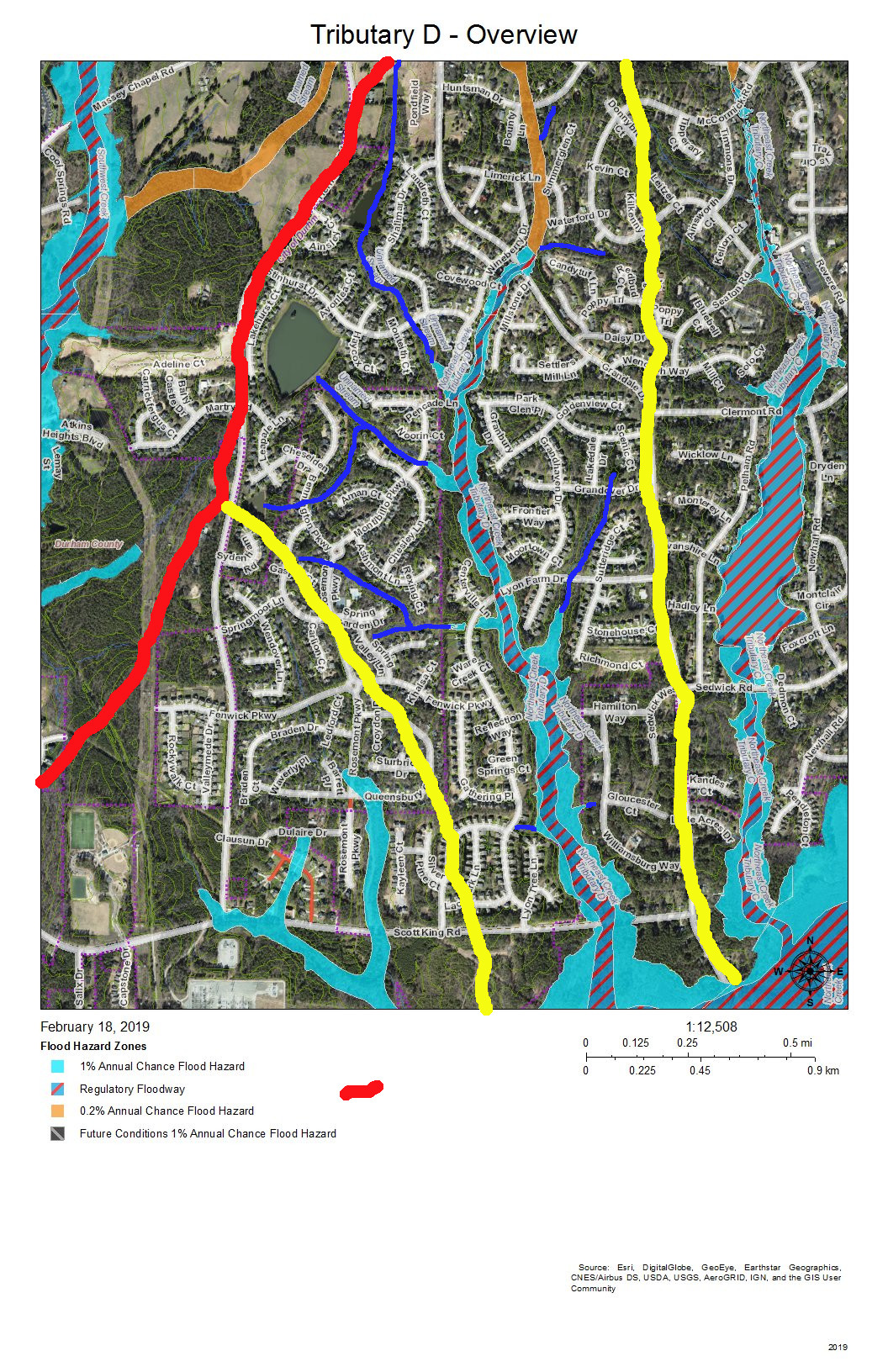
Here is an overview of Tributary D:
Overview of the Tributary D sub-basin
On this map, the red line is the boundary with the Crooked Creek basin. The yellow lines mark the sub-basin of the west fork of Tributary D and the dividing ridge along Grandale that separates Tributary D from Tributary C.
Skim through the maps to the part of Tributary D that you want to examine and then click on the map to enlarge. The sections with streams with blue solid or dotted lines are the section of Tributary D that for which the map is a guide, To enlarge further use the + keys in your viewer or Ctrl-+ on the keyboard. There will be some street references in the text following each map.
Yellow lines mark the sub-basins of Tributary D. Blue lines are the creeks in the area in the map title. Dotted blue lines are intermittent creeks inferred from the topography or known significant stormwater pipes. The impervious surfaces of roofs are orange within the City of Durham, and the impervious surfaces of parking lots, driveways, and other concrete structures are gray, also within the City of Durham. Outside the City of Durham in Durham County, with the image enlarged enough you can generally understand where roofs, driveways and sidewalks are.
Looking from the mouth of Tributary D and Northeast Creek, the sequence of maps examines each upstream branch and the main stream of Tributary D back to its source near the pond in Hunters Woods.
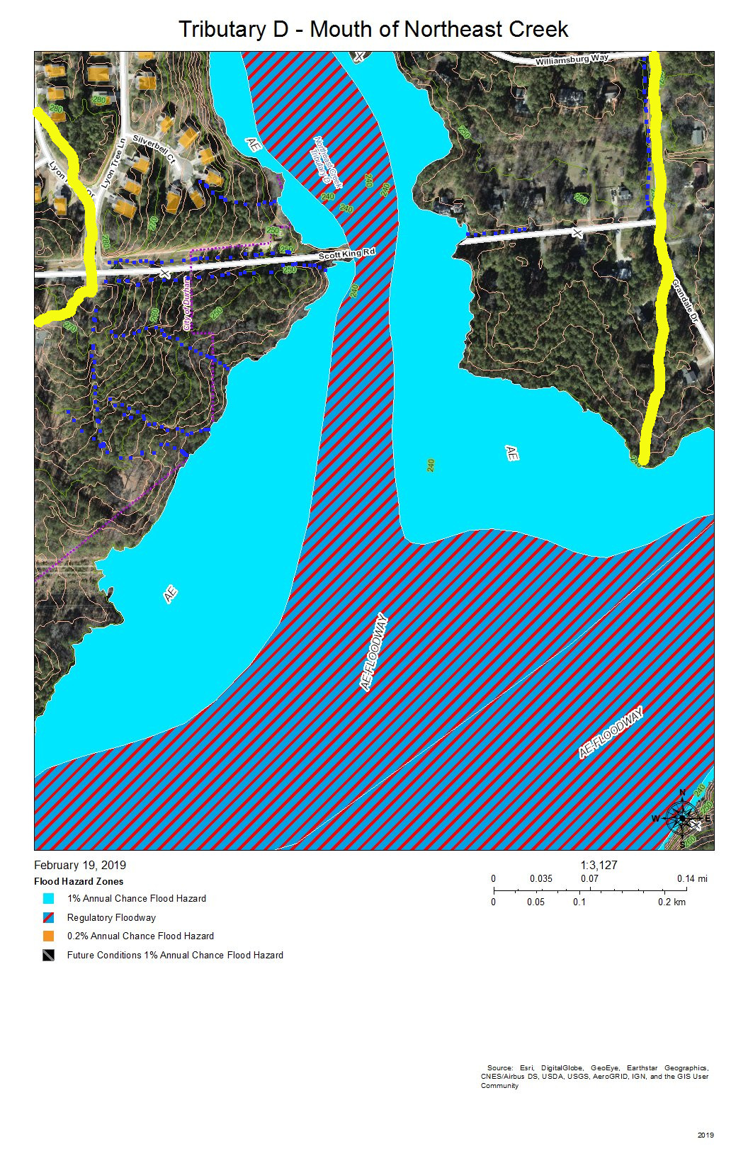
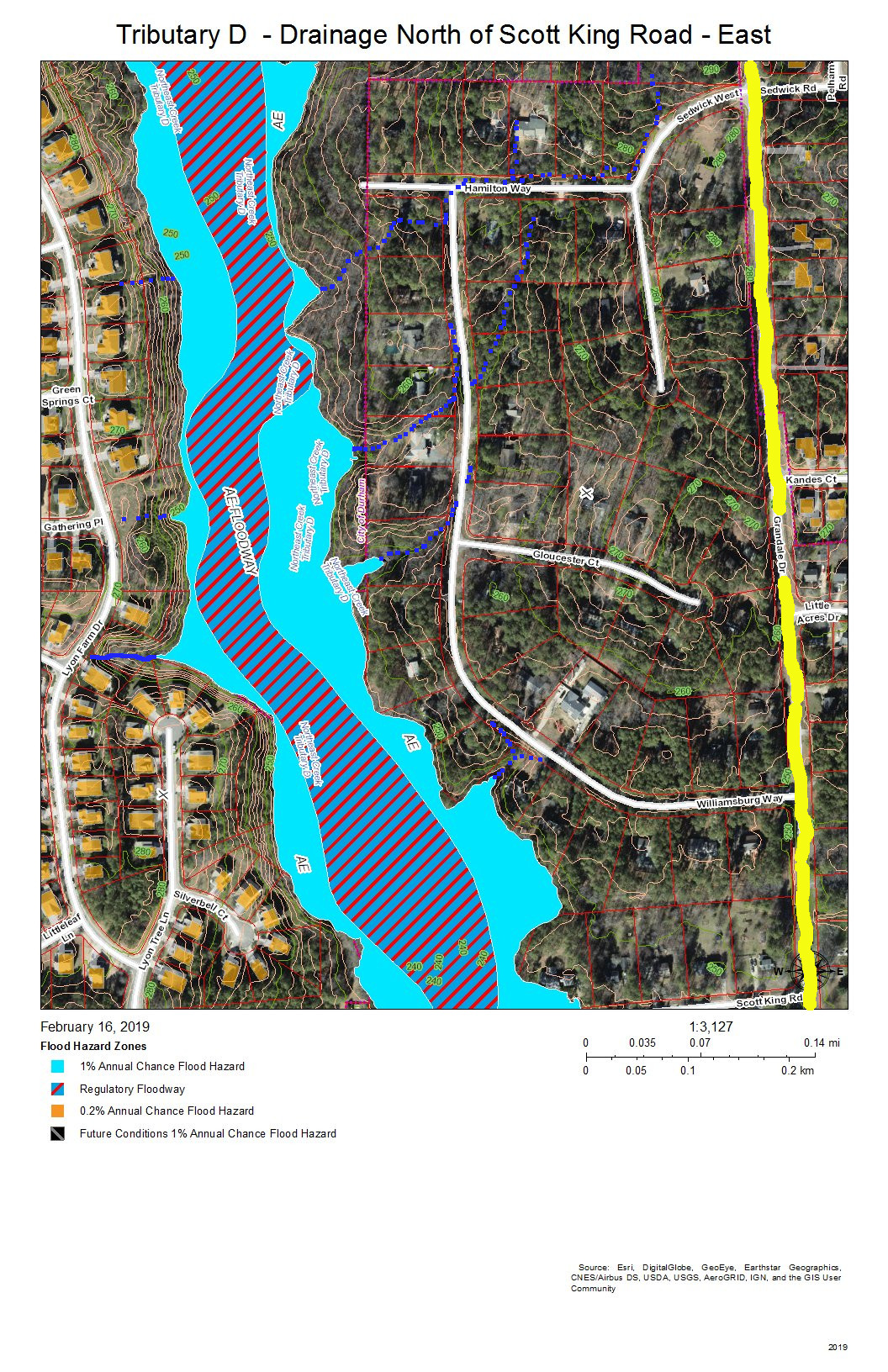
Tributary D – Mouth at Northeast Creek
Almost all of the section floodway of Tributary D in this map of the map is in US Army Corps of Engineers land surrounding the headwaters of Lake Jordan. This property does extend north of Scott King Road.
The drainage channels shown on this map are primarily intermittent streams that flow down the swales on either side of Scott King Road and intermittent streams flowing down slopes into Tributary D.
This is an area in which we have cleaned out tires from Corps of Engineers property in past clean-ups.
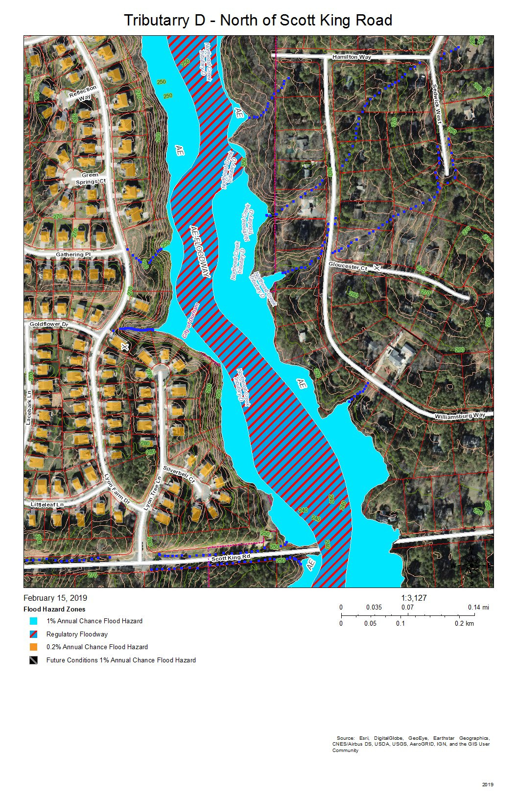
Tributary D Main Stream – North of Scott King Road
This section of Tributary D is between Lyons Farm on the west and Lake Park on the East. Most of the drainage is from runoff down the slopes, from stormwater pipes not shown on this map, or from the intermittent streams at various points on the stream bank.
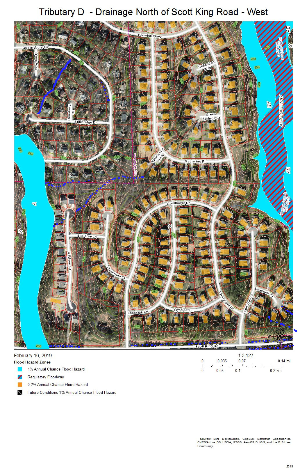
Tributary D – Drainage from West Bank North of Scott King Road
Fairfield, Grandale, and Lyons Farm are the neighborhoods between Tributary D on the east and a fork of Tributary D on the west that crosses Scott King Road just west of Goldflower Drive and joins the Tributary D wetland in Corps land.
East Bank of Tributary D North of Scott King Road
Lake Park is the neighborhood on the east bank of Tributary C north of Scott King Road. Drainage is from intermittent streams or stormwater pipes not shown on this map.
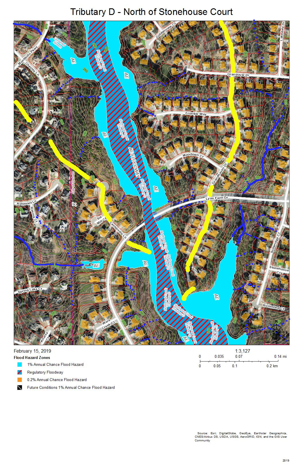
Tributary D – Main Stream North of Stonehouse Court
Fairfield, Grandale, and Grandale Place are the neighborhoods where the main stream of Tributary D meets some of its own tributaries.
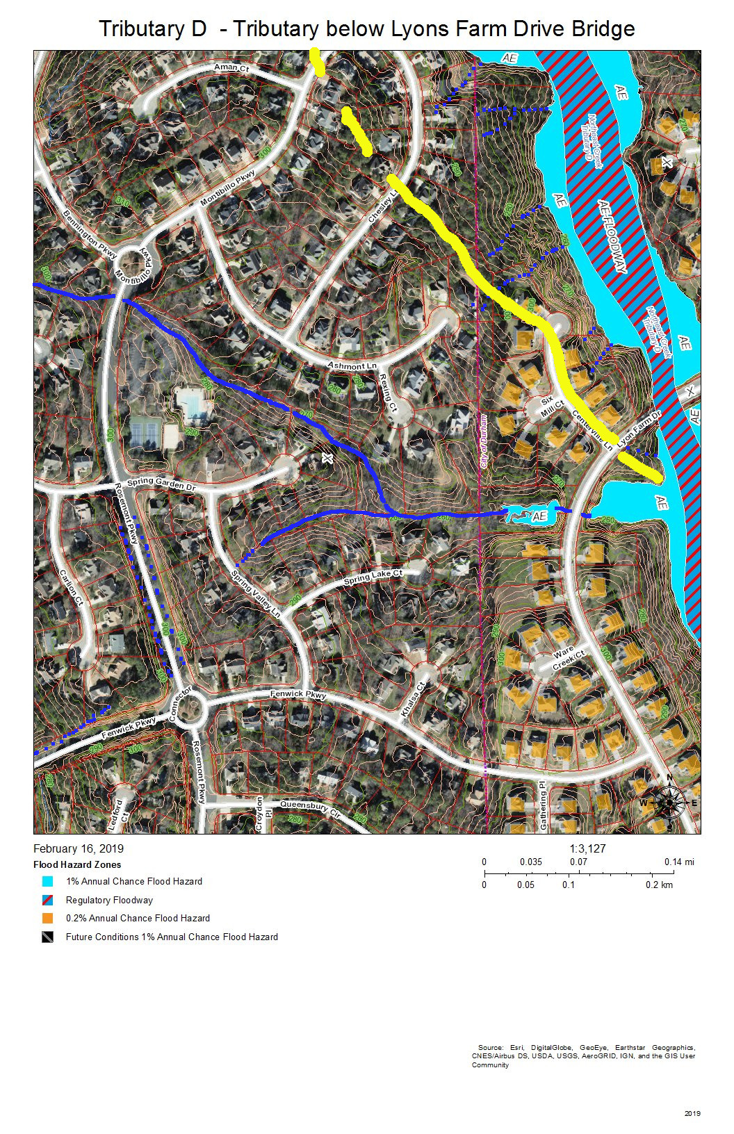
The west bank of Tributary D below the bridge for Lyons Farm Drive.
Fairfield and Grandale are the neighborhoods on this section of Tributary D. A tributary stream crosses under Rosemont Parkway just south of the circle on Montibillo Parkway. The yellow line marks the watershed ridge separating the main stream of Tributary D from this tributary.
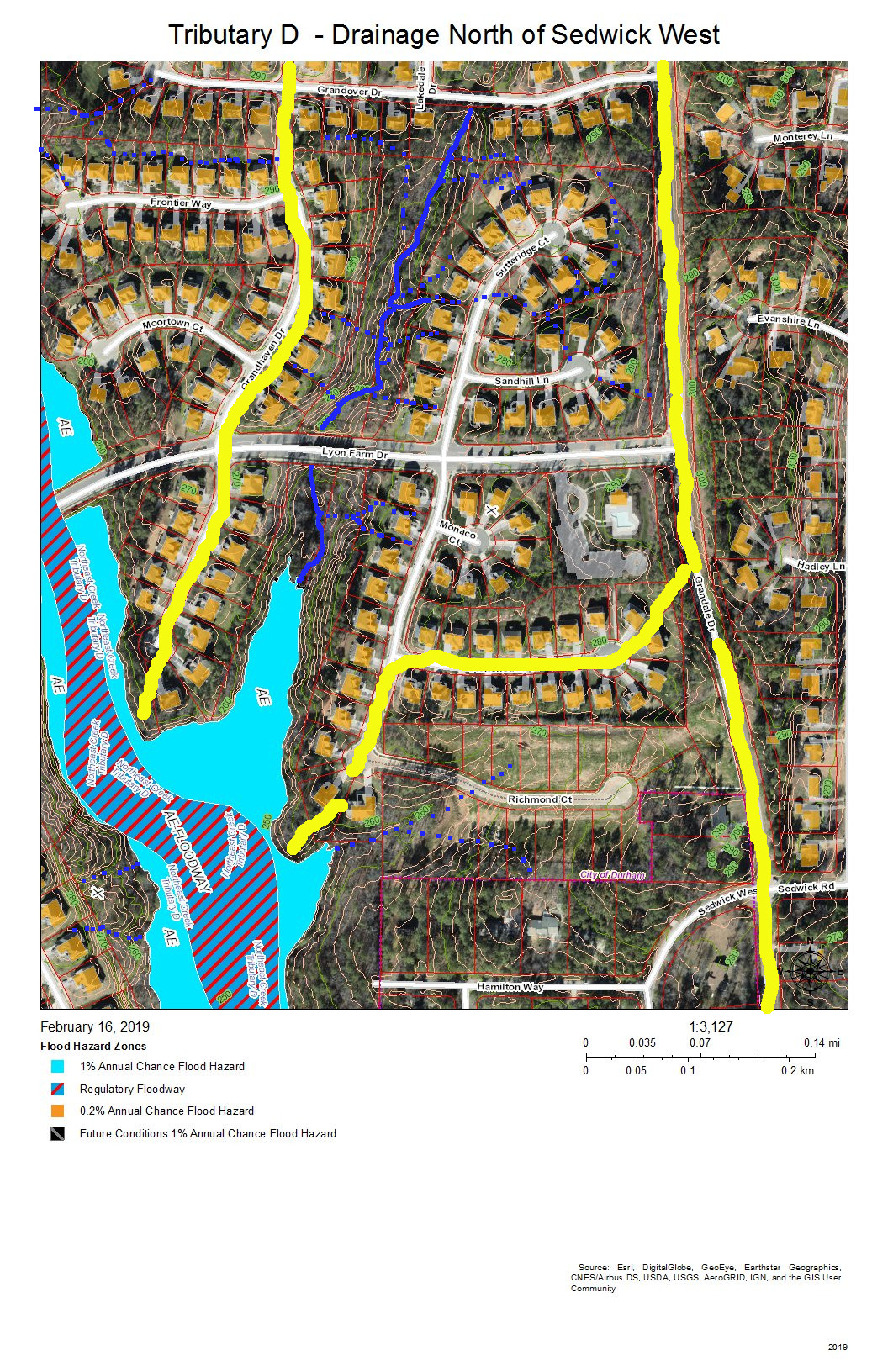
Tributary D Drainage – East Bank North of Sedwick West
Grandale is the neighborhood in this view, and the neighborhood building at the entrance from Grandale Drive is the one with the L-shaped parking lot. The yellow line along Grandale marks the watershed ridge with Tributary C. The other yellow lines outline the sub-basin of the tributary from Grandover Drive that joins the main stream of Tributary D in this view. Other drainage is from intermittent stream (dotted blue lines) or stormwater pipes not visible on this map.
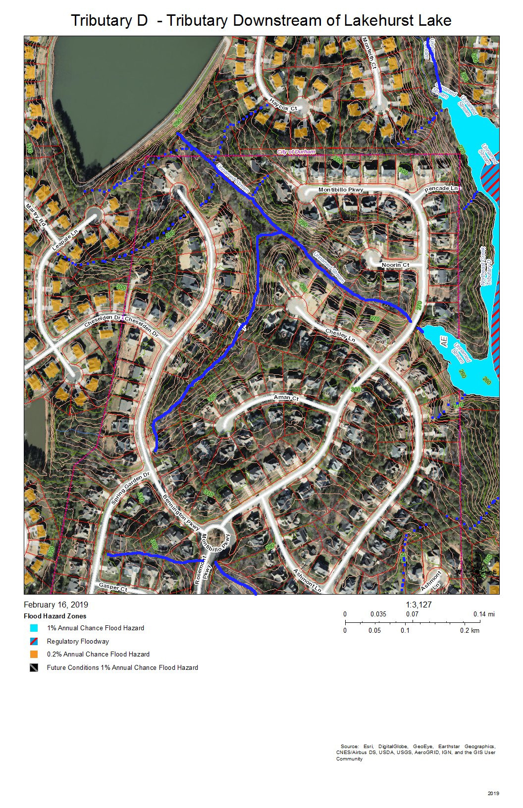
Tributary D Downstream from Lakehurst Lake
Fairfield and Lakehurst are the neighborhoods in this view. The lake in the Lakehurst neighborhood dams the tributary that flows into Tributary D and that acts somewhat like a retention pond moderating wet and dry weather patterns. Elsewhere, intermittent streams and stormwater pipes not visible on this map drain the runoff from development into the tributary streams.
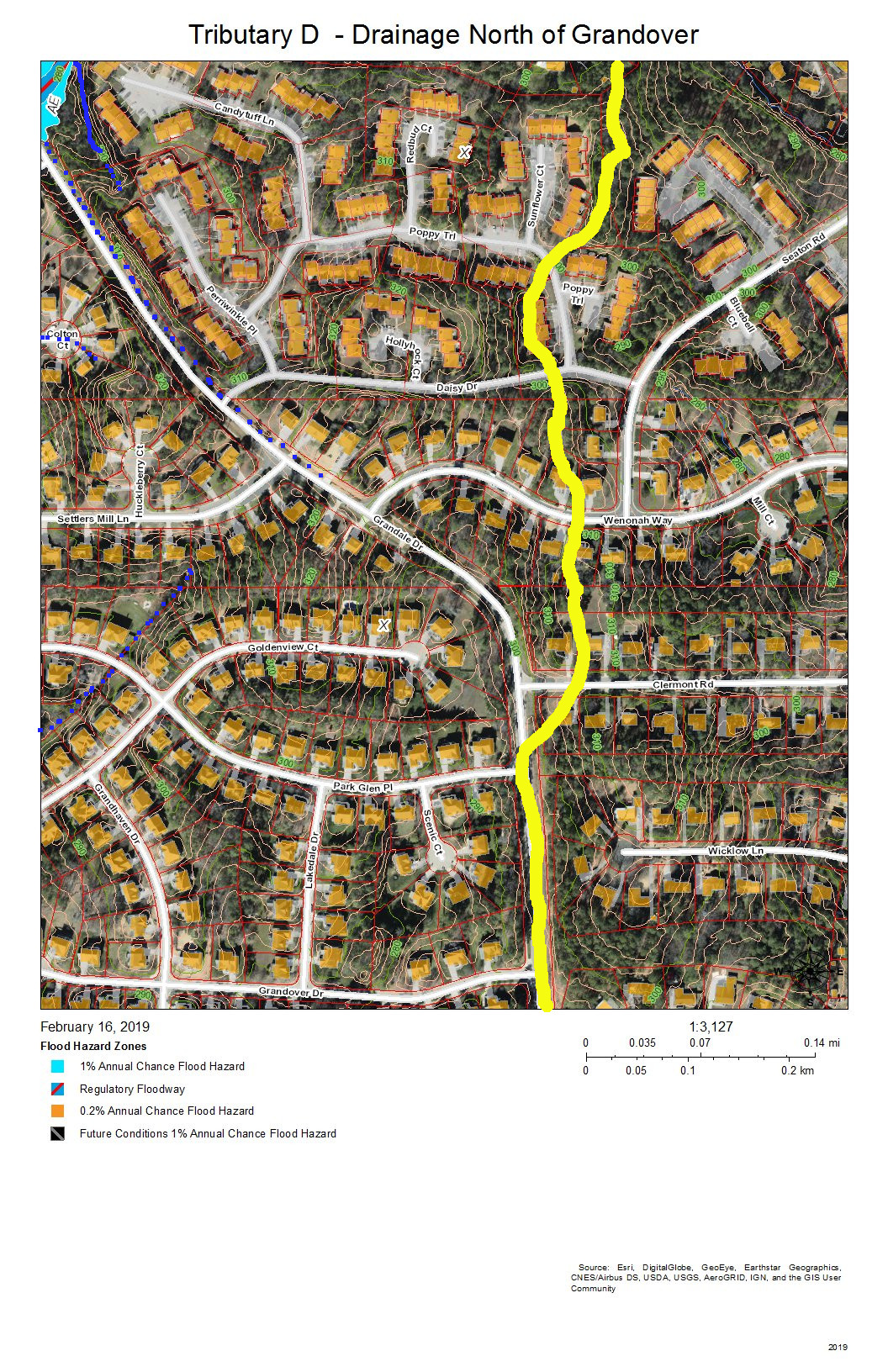
Tributary D – Drainage North of Grandover Drive
Grandale Place, Settlers Mill, and the Ridges at Parkwood are the neighborhoods in this view. The drainage flows through stormwater pipes not visible on the map and down intermittent streams (marked with blue dots).
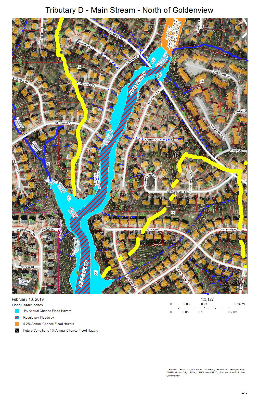
Tributary D Main Stream – North of Goldenview Drive
Grandale Place, Settlers Mill, Grandale Forest, and Lakehurst are the neighborhoods in this view. The yellow line at the top is the watershed ridge separating the fork that drains north of Stinhurst Drive from the main stream. The other yellow line shows the sub-basin of the tributary intermittent streams that drain Grandale Place; this might be supplemented with stormwater pipes not shown on this map.
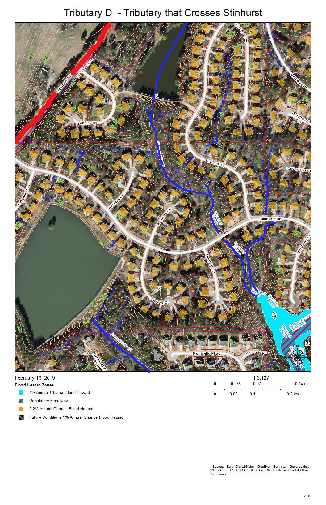
Tributary D – Tributary That Crosses Stinhurst Drive
Lakehurst Pointe and Lakehurst are the neighborhoods in this view. The red line shows the watershed ridge between the Northeast Creek basin and the Crooked Creek basin. Two tributaries of Tributary D join the main stream beyond the cul-de-sac at the end of Wineberry Drive. One of these originates above the lake in Lakehurst Pointe; the other originates between the cul-de-sacs of Landreth Court and Middlebury Court in Lakehurst Pointe.
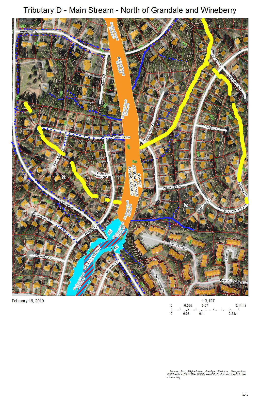
Tributary D Main Stream North of the Intersection of Grandale Drive and Wineberry Drive
Grandale Forest and Parkwood are the neighborhoods in this view. The intersection of Grandale Drive and Wineberry Drive are the point at which a tributary from the southwestern section of McCormick Road, an intermittent creek from the Ridges, and the intermittent creeks that flow down the swales on either side of Grandale Drive merge before crossing through two 4-foot pipes under Grandale Drive and flowing behind the houses on Wineberry Drive. Over 20 years, the section of creek along Wineberry Drive has scoured almost four feet of depth in the streambed, and water still overflows into yards in heavy rains.
Tributary D – Drainage North of Candytuft Lane
The Ridges of Parkwood, Parkwood, and Hunters Woods are the neighborhoods in this view. The yellow line marks the watershed ridge between Tributary D and Tributary C. Two tributary streams drain this area–one south of Huntsman Drive and one north of Candytuft Lane. An intermittent stream drains the west side of the McCormick highlands and flows down McCormick Road. Another intermittent stream flows down Limerick Lane.
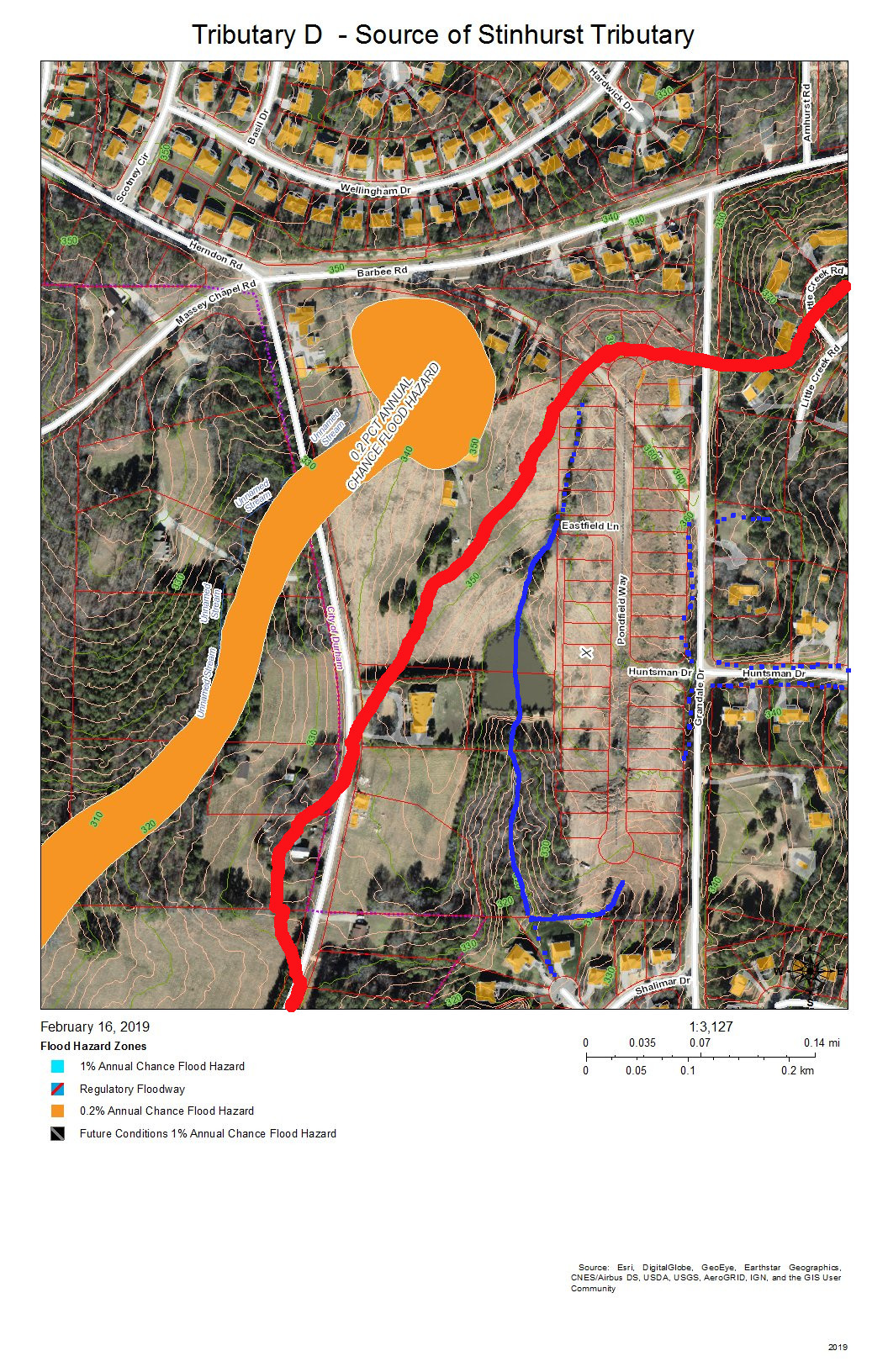
Tributary D – Source of the Tributary Stream from Lakehurst Pointe Lake
Lakehurst Pointe and Grandin Trace are the neighborhoods in this view. The red line is the boundary between Tributary D and the Crooked Creek basin. The source is in what is soon to be the northwest corner of Grandin Trace and flows into a pond that releases a stream that flows openly and then through stormpipes into the lake in Lakehurst Pointe.
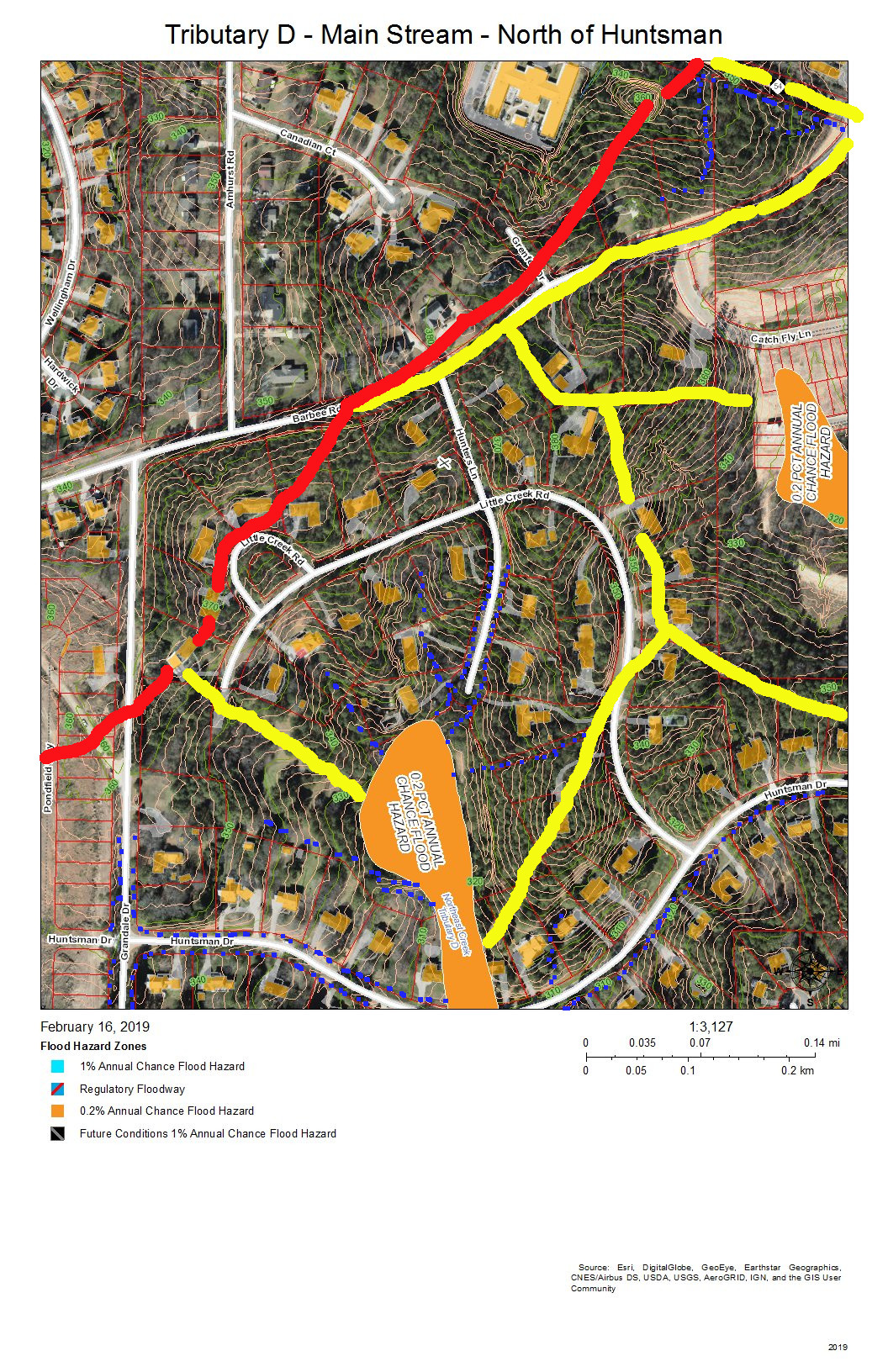
Tributary D – Main Stream North of Huntsman Drive
Hunters Woods is the neighborhood in this view. The yellow lines on the east are two sub-basins of tributaries of Tributary C that drain the Meadows at Southpoint. The red line is the watershed ridge between Crooked Creek and Northeast Creek. The yellow line along Barbee Road is the drainage off of Barbee Road that road construction has shifted from the Northeast Creek basin to the Crooked Creek basin. A local high point (elevation over 380 feet) was the site of a NC Forest Service fire tower until shortly before Hunters Wood was developed. This high point allow a ranger to see many square miles of woodlands cultivated on the uplands and bottomlands of Northeast Creek and Crooked Creek.
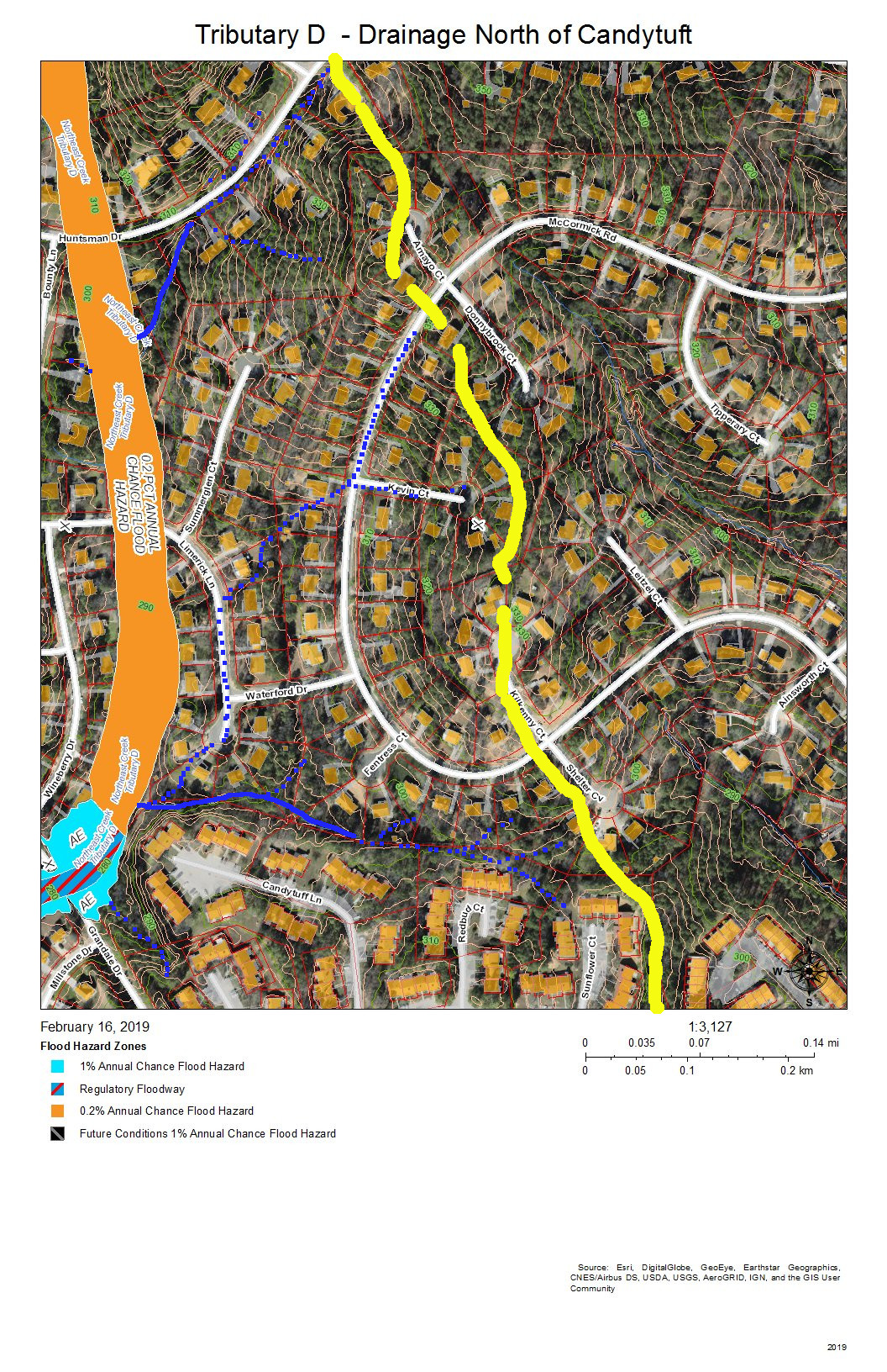
Tributary D – Drainage North of McCormick Road
Parkwood and Hunters Woods are the neighborhoods in this view. The yellow line marks the watershed ridge between Tributary D and Tributary C. The orange in Tributary C is the 0.2 percent chance flood zone in the headwaters of the Meadows at Southpoint retention pond. The orange in Tributary D is the Hunters Woods lake and the overflow path if the dam is topped; this is also a 0.2 percent chance flood zone.
All of the maps in this series are works in progress that need investigation by residents of the neighborhoods reporting what they see on the ground. There are many points that are not clear from aerial views about how the drainage flows. One issue in particular is how the retention pond from Grandin Trace flows into the lake in Lakehurst Pointe. As we get corrections we can edit the maps to apply them and eventually have maps to provide an atlas of the Tributary D basin.
Creek Week is coming March 13 through 20. During that week Durham is focusing attention on how individual citizens and property owners can with modest efforts deliver significant benefits to the quality of water moving downstream, especially to Jordan Lake.
A fun activity during Creek Week is to find the path that water from your roof, sidewalk, driveway, and patio or deck takes as it goes to Northeast Creek, down Northeast Creek and into Jordan Lake, and down the Cape Fear River to Wilmington.
To do that, we must perceive streams and their tributary flows of runoff (the water) in the foreground and land in the background. Focusing on the flash flood zones at full flood (the flood zones identified on the maps) shows the land as necks extending into the fully flooded lake headwaters. After all, one of the primary purposes of Lake Jordan was mitigation of the flash flooding that often occurred in the Haw River and New Hope Creek basins.
The coloring of the flood zones represent the following:
Solid blue: 1% annual chance flood hazard
Blue with red diagonal stripes: Regulatory floodway
Gold: 0.2% annual chance flood hazard
Black with gray diagonal stripes: Future conditions 1% annual chance flood hazard.
A second fun activity is to explore the wetlands on US Army Corps of Engineer land set aside for the headwaters of Jordan Lake. The wetlands in these areas comprise:
periodic flood plains that flood with every rain and become dry land with every dry spell;
freshwater marshes;
periodic swamp forests;
persistent swamp forests that give way to snags (dead trees that host animals like woodpeckers) then become pools of blow-downs (blown-over dead trees);
tightly meandering stretches of stream;
braided streams;
oxbow ponds.
These organize themselves to best handle the flow of water through the wetlands in wet and dry periods.
On the maps, wetland features are marked with dotted blue and orange lines.
A previous post showed that Parkwood comprises parts of three sub-basins:
Tributary D draining the western part of the McCormick high land and streams from Hunters Woods joining and running down Wineberry to the west.
This post presents maps to help find the path that the water takes from the roof of a particular house to the main stream of Northeast Creek and the features of the Northeast Creek wetlands that it passes through. Future posts will look at what you can do on your own property to help preserve effective functioning of Northeast Creek.
The following map is an overview of the Northeast Creek main stream from Carpenter-Fletcher Road downstream to the American Tobacco Trail bridge over Northeast Creek on the trail a half mile south of the Scott King Road trailhead.
The red line is the watershed ridge on the west between the Northeast Creek basin and the Crooked Creek basin.
Main Stream – Overview
From left to right the sub-basins of Northeast Creek are:
A fork that arises in the Southhampton neighborhood and the edge of C. M. Herndon Park on Scott King Road;
Tributary D;
Tributary C;
A tributary that runs from the Legacy at Meridian;
A tributary that runs out of the Auburn neighborhood;
A tributary that crosses Woodcroft Parkway east of Barbee Road;
A tributary that flows into Meridian Park;
The North Prong of Northeast Creek, the major tributary that flows down the west side of NC 55 and through Meridian Park;
The main stream (Northeast Prong) of Northeast Creek;
Buck Branch, which flow out of the old EPA campus area;
The north fork, main stream, and south fork of Burdens Creek, which drains the central section of Research Triangle Park;
Long Branch of Kit’s (Kitt’s) Creek;
Another branch of Kit’s Creek, which drains the southern section of Research Triangle Park.
Main stream of Northeast Creek.
This series of maps will show the western side (Parkwood side) of the main stream, that wide, blue and blue-and-red floodway that:
starts at the top right of the map,
flows south,
then west again in passing the Red Roof Inn on NC 55 north of I-40 and connecting with the North Prong in the southeast corner of Meridian Park,
then south again at the Doubletree Inn;
then it crosses under I-40 and flows through a wetland between Parkwood and NC 55;
Burdens Creek joins it from the east and Research Triangle Park;
then turns west flowing south of Audubon Park and Parkwood, through Corps of Engineers unforested land and a Duke Energy high-voltage line easement;
then it crosses under Grandale Road passing through forested Corps of Engineers land (NC Gameland);
it crosses into Chatham County;
Kit’s Creek joins it from the southeast and the southern part of Research Triangle Park;
it flows under the bridge for the American Tobacco Trail, a bicycle and pedestrian trail.
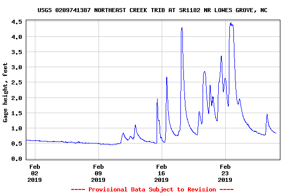
There are two stream gages placed by the US Geological Service on this section of Northeast Creek, one at Carpenter-Fletcher Road and the other at the bridge on Grandale Road. To provide a view of what this section of the main stream does, here is the February 2019 stream gage data for the Carpenter-Fletcher Road gage. Notice that the level during moderate periods is around 0.5 feet (6 inches), but rain quickly causes the level to rise to 2, the 2.5, then 4.5 feet. Remember these numbers when we come to the data from Grandale Bridge.
Stream Depth North Prong of Northeast Creek at Carpenter-Fletcher Road – February 2019
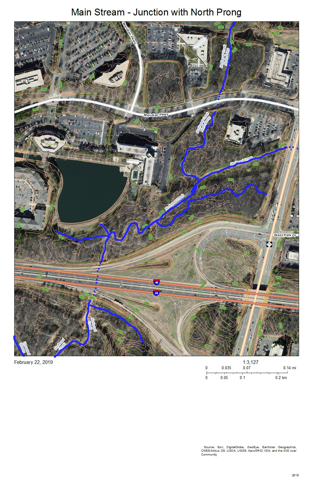
That stream gage is just upstream (north) on the North Prong (out of view off the top of this map).
Junction of the North Prong of Northeast Creek with the Main Stream
The North Prong drains the Northeast Creek watershed south of Riddle Road and southwest of the intersection of Riddle Road and Alston Avenue. When it enters Meridian Park it flows into a wetland between NC 55 and Meridian Parkway (top right on the map).
Main Stream of Northeast Creek North of the NC 54 Bridge
I-40 appears at the top right of this map. The dotted blue line on I-40 is roughly where the culvert for Northeast Creek goes under I-40 and spills into the flood plain to the south. At the left end of NC 54 on the map is Christus Victor Lutheran Church; at the right end is Chik-Fil-A. The bridge is where the wetlands on the north side of NC 54 spill through to the south side of NC 54. This area regularly has high water during rainy spells.
Almost all of this wetland area except for the various stream channels is a wide intermittent flooded area during rainy spells. Drier weather allows for plant succession until water collects so frequently in those areas that it drowns out vegetation or gets replaced with water plants.
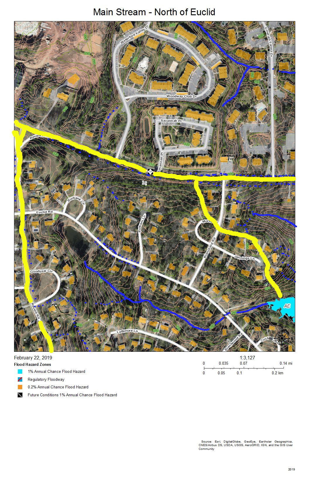
Main Stream North of Euclid Drive
The drainage of the sub-basin north of NC 54 gets directed parallel and south of I-40 and flows into the wetlands south of I-40 and north of NC 54 (in the previous map). The sub-basin on the top right has a stream that flows from the intersection of Blanchard Road and NC 54 southeast into the engineered pond behind the commercial buildings on NC 54. The third sub-basin flows out of the pond at the Revere Road end of Euclid Drive, between the houses on Lattimore Lane and Euclid Road, under Euclid Drive at the bottom of the hill, and down a restored stream that replaced a culvert and into the main stream of Northeast Creek in the wetlands.
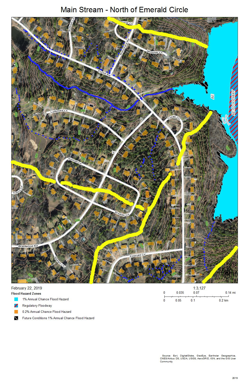
Main Stream North of Emerald Circle
The sub-basin at the top shows the drainage into the creek that flows from the pond at the Revere Road end of Euclid Drive and the creek that crosses Euclid Drive along the road to the former package sewer plant location (when Parkwood contracted its own private water and sewer service). The sub-basin at the bottom left is the area on Brentwood Road that flows into Tributary C. The remaining sub-basin is the intermittent stream that drains Emerald Circle.
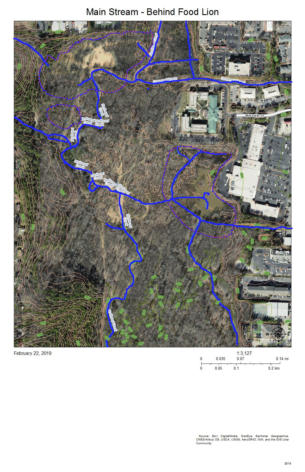
Main Stream – Behind Food Lion
The complex pattern of blue lines (stream channels) on this map shows the effects of a strongly meandering and braiding Northeast Creek and the engineered attempts to reduce flooding of the parking lots of the properties backing up on the wetlands. All of the water from the parking lots built on what used to be farmland adjacent to bottom land instead of somewhat soaking into pasture or woodlands, now all flows into the wetlands. Commercial property owners nationwide are only now beginning to investigate how to better manage stormwater on commercial properties. Local governments have mandated certain best management practices for stormwater management over the last ten to twenty years. The most obvious of these to most customers are the retention ponds on the edge of commercial developments.
The blue and orange dotted lines encircle areas of open water in the areas behind the commercial properties on NC 54 and the Food Lion shopping center on NC 55.
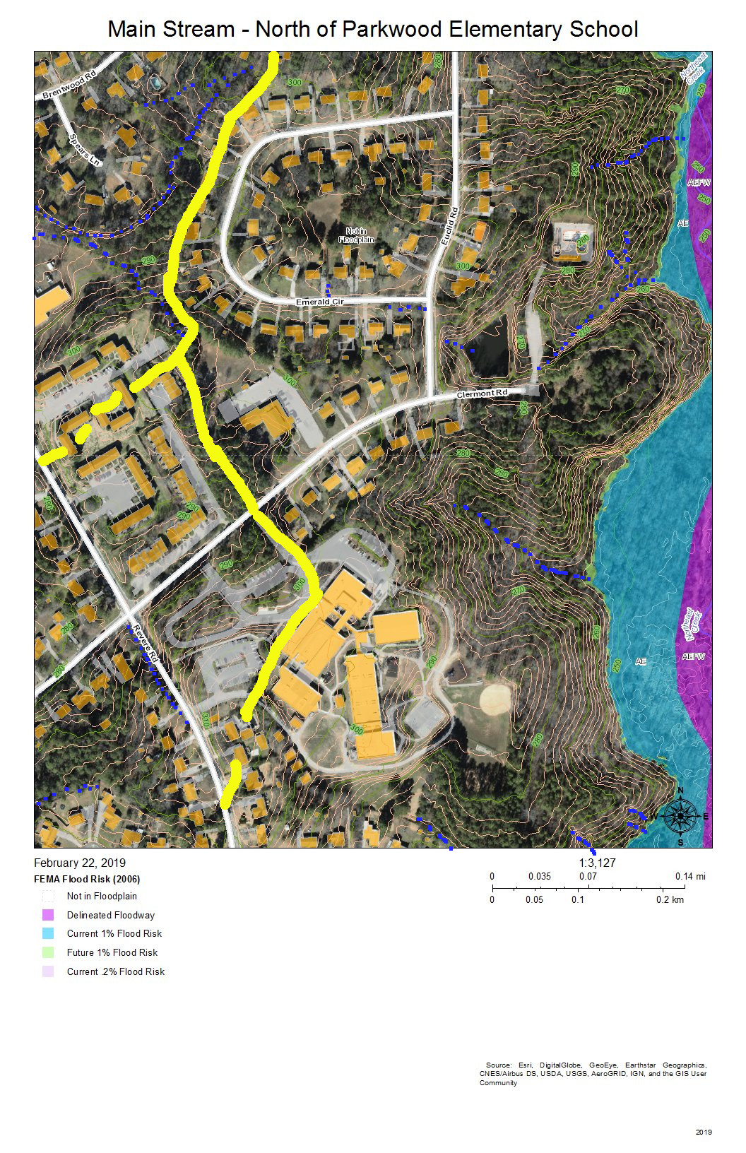
Main Stream – North of Parkwood Elementary School
The sub-basins to the left of the map drain into Tributary C (Parkwood Lake). Parkwood Elementary School has engineered stormwater management of its site. The houses on Radcliff Circle drain down the vegetated ground cover of the buried sewer outfall to the main sewer line that goes to Triangle Wastewater Treatment Plant on NC 55.
Main Stream – North of Greenwood Common
As the intensity of commercial development on the eastern edge of the wetlands diminishes and as the force of flooding during rainstorms is absorbed by the size of the bottomlands, there are fewer engineered channels and the channels go from braided to parallel meanders. The blue lines show stream channels; the blue and orange dotted lines show the perimeter of the more permanent swampy and marshy areas toward the eastern edge.
At the bottom of the map behind Greenwood Commons, the eastern side is a cattail marsh with a few snags. This marsh has been flooded by a natural dam of crushed branches and cattail stems that elevates the water impounded slightly above the western branch, which has a series of meanders. The two branches join shortly before the main stream passes under the bridge on Sedwick Road.
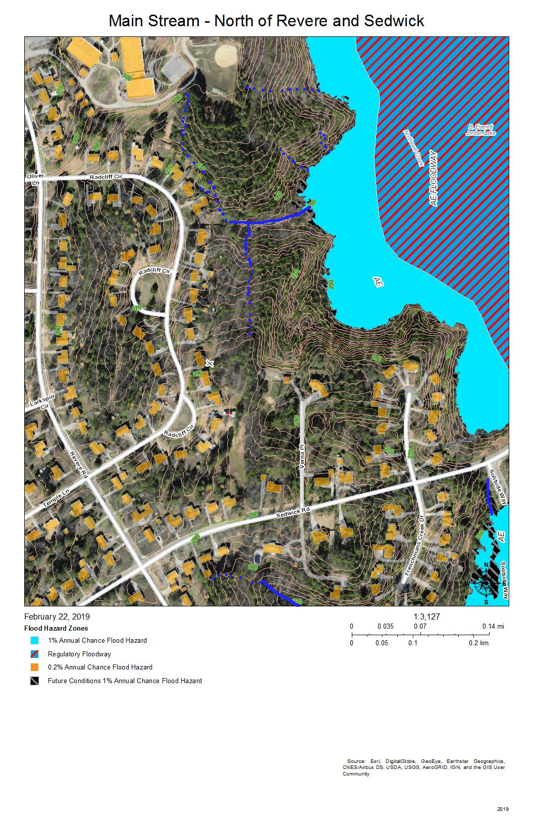
Main Stream East of Revere Road and North of Sedwick Road
The primary drainage between the heights at the Parkwood Elementary School building and the short ridge on which Frenchman’s Creek Drive is built is the grassed sewer line easement (solid blue line) that runs from Radcliff Circle back to the main sewer outfall easement in the wetlands; both of these easement are somewhat wet from unevaporated stormwater except in very dry periods because of the intermittent streams (dotted blue lines) and groundwater flows that allow what rainwater that does soak in to be delayed in adding to the stream flow.
Water runs off the impervious surfaces, such as roofs (orange), driveways (gray), and streets (white). The runoff that comes through the dark green forested area that have a lot of leaf litter moves much slower. The water that does percolate through into groundwater move slower still.
The simple rules for managing rainwater on your own property are:
Slow it down.
Spread it out.
Soak it in.
This area shows how the undisturbed common land buffer on the steeper upland slopes between the individual house property and the wetlands carries out those functions.
Main Stream at Sedwick Road Bridge
The blue lines show:
To the west, the meandering stream channels of the west branch of the main stream of Northeast Creek running just east of the sewer line easement that runs to the Triangle Wastewater Treatment Plant.
Coming in from the southwest, the tributary stream that has formed from the accumulated groundwater and runoff flowing from the heights of Parkwood Elementary School, Radcliff Circle, and Frenchman’s Creek Drive.
From the marsh behind Greenwood Commons, the stream channel that has flowed nearest the commercial properties on NC 55.
The joining of the two meandering channels into the single Northeast Creek main stream
A tributary paralleling Sedwick Road and draining that part of Frenchman’s Creek Drive
The single channel of the main stream of Northeast Creek flowing under the Sedwick Road bridge.
Burdens Creek and its wetlands joining Northeast Creek from the east.
A north-flowing creek to the east of Solitude Way.
An oxbow lake just southeast of the junction of Burdens Creek and Northeast Creek.
The blue and orange dotted line encircles an area that became a intermittent pond after the property was logged. The property is going through succession of vegetation and now is beginning to have small trees and forest sub-story beginning to grow. Several years ago there was a cattail marsh in this wet spot.
You can also see some of the unmarked meanders, tributaries, and oxbow lakes as darker areas near the streams.
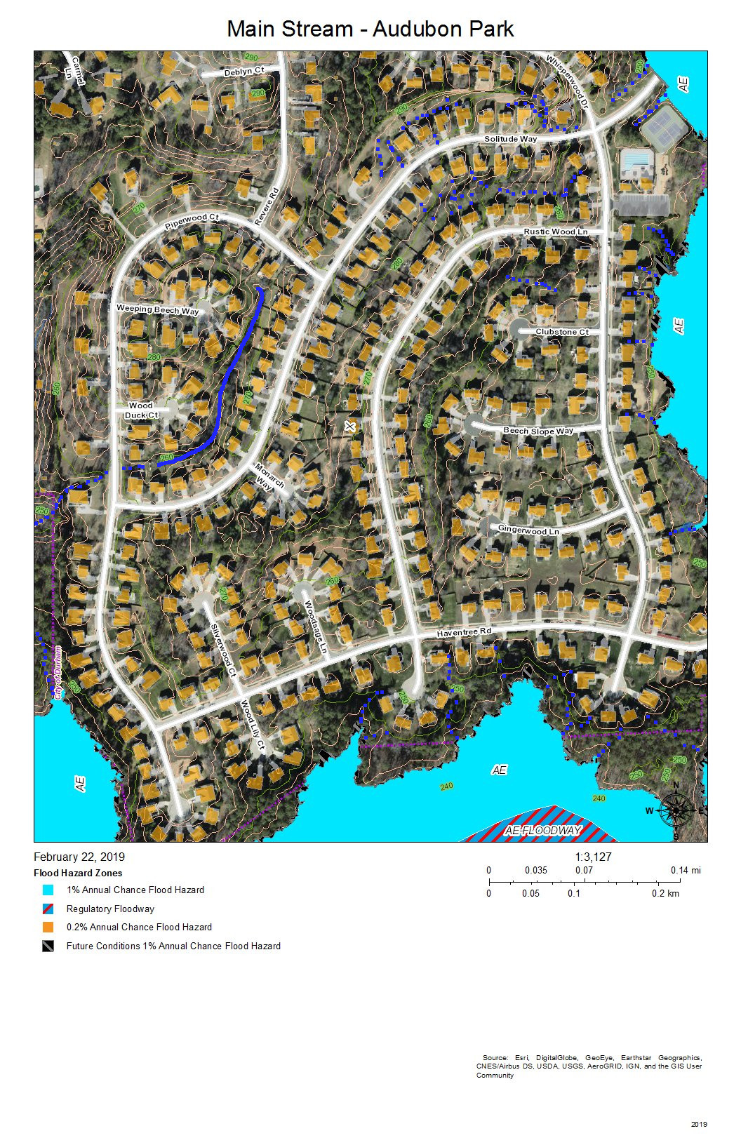
Main Stream at Audubon Park
Audubon Park was developed with intensive site preparation and most likely stormwater pipes and structures to conduct runoff quickly into the wetlands to the east and south. What appears on this map is a stream inside Piperwood Circle and Solitude Way. There are also indications from the topography that intermittent streams might form with the slope of the ground and run off at the edges of the wetlands; after almost 20 years, there might be gullying at the edge of the wetlands (near where the blue dotted lines meet the color coding of the flood zones). Homeowners in Audubon Park have the best view of how the water runs because so much of the drainage is enclosed interior to a bunch of houses and not visible by the public.
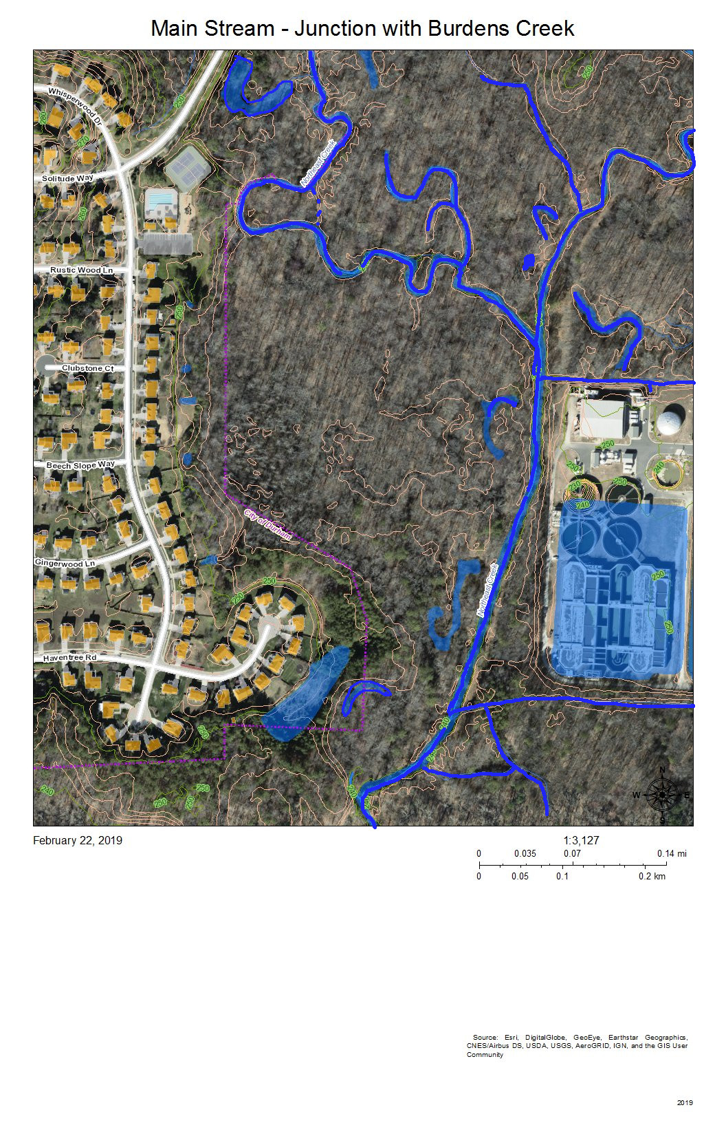
Main Stream – Junction with Burdens Creek
The wetlands east of Audubon Park show the meanders and oxbow lakes of intermittent flooding of bottomland forest in the area where Burdens Creek, coming in from the northeast, meets the main stream of Northeast Creek, meandering in from the north and making a eastward turn. The Triangle Wastewater Treatment Plant is at the lower right.
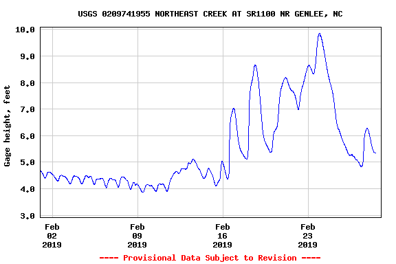
The processed wastewater coming out of the Triangle Wastewater Treatment Plant tests cleaner than the water in Northeast Creek at the outlet point. Also, the volume of wastewater flowing through the Triangle Wastewater Treatment Plant cause a baseline oscillation of roughly 6 inches (0.5 feet) in the USGS stream gage at the bridge on Grandale Road of a typical dry-period stream height of 3.5 feet. (Notice this on the stream gage report at the end of this post.)
Main Stream – Bend to the West
The main stream turns to the west around the southeast corner of Audubon Park. On the map, the development at top right is the back edge of the Triangle Wastewater Treatment Plant. The blue lines are the meanders and loops of the main stream of Northeast Creek and the tributary streams that drain other parts of the wetland.
The area on the left marked with a blue and orange dotted line locates a former swamp forest, now characterized by snags and fallen trees killed by the persistent deeper water.
The two lines across the bottom are the high-voltage power line running from a substation on NC 55 to a substation on Scott King Road by the American Tobacco Trail.
This section is where Corps of Engineers ownership of the headwaters of Jordan Lake begins on Northeast Creek.
Main Stream South of Audubon Park
This view is slightly to the west of the previous view; the area of snags and fallen trees noted at the left of the previous view is in the center of this view. To the left of this view is another swamp forest in decline.
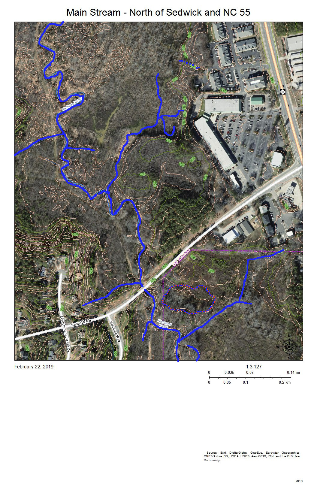
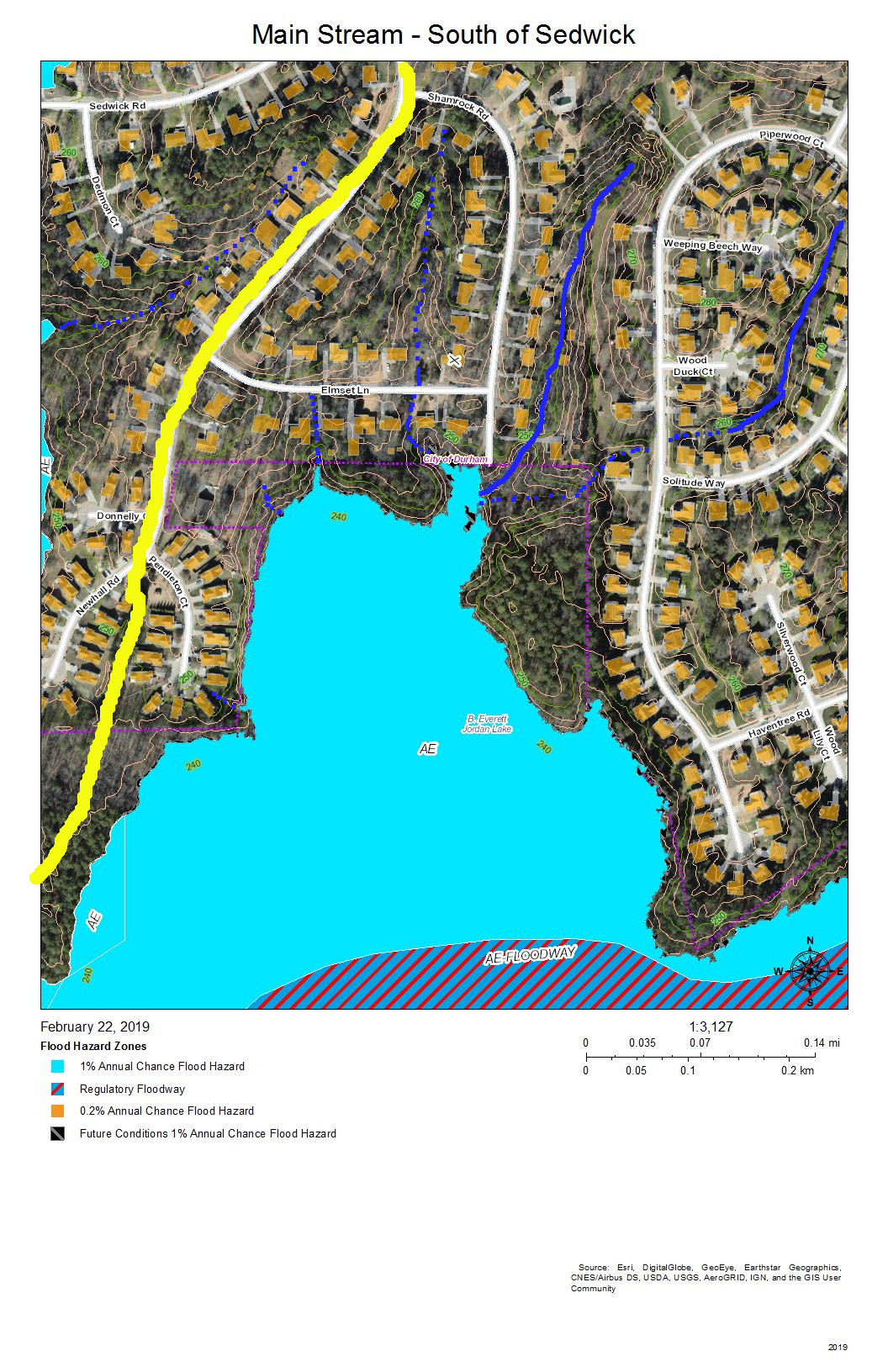
Main Stream – South of Sedwick
The yellow line is the headwaters ridge between the main stream of Northeast Creek and Tributary C of Northeast Creek.
The solid blue lines are the more permanent streams, and the dotted blue lines are the intermittent streams that drain the streets off Newhall Extension in Parkwood.
At the end of Shamrock Road is a triangular-shaped upland buffer of common land that faces out on a large freshwater marsh interrupted by some of the areas of flooded snags and fallen trees. Notice that the buffers between the newer developments and the wetlands are much narrower.
Main Stream South of Parkwood
This is the same as the previous view but without the color coding for flood hazard areas. The yellow line is the watershed ridge between the sub-basin of the main stream and the sub-basin of Tributary C of Northeast Creek. The areas enclosed in blue and orange dotted lines are areas that are more permanently wet, such as snag areas, freshwater marshes, and open ponds. There is an area in the water at the end of Pendleton Court that is light green; this appears to be algae bloom. Beyond it is a dark area of open water, and then the speckled area of the freshwater marsh. Toward the bottom left is a dark open water area, enclosed with a blue and orange dashed line, in which fallen trees are clearly visible. Within the marsh are thin, short slashed lines that are the shadows of standing trees. The open water through the marsh shows meanders that might show areas of faster flow.
On the bottom right is a 40-foot hill that forms a bluff at the southern edge of Northeast Creek.
All of the ricocheting of water in this wetland slows it down and allows it to spread across the low areas and soak in as best it can in the Triassic and floodplain soils.
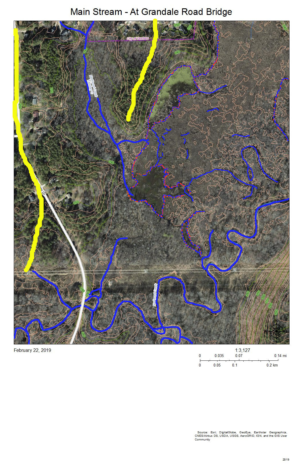
Main Stream at Grandale Road Bridge
The Grandale Road bridge is just south of where the high-voltage power lines cross Grandale Road.
The yellow lines mark the headwater ridges that separate the sub-basins of, from east to west: the main stream, Tributary C, and Tributary D of Northeast Creek.
The features of the wetland north of the power lines are those we have discussed above. This view shows more of the wetlands to the west and south.
The 40-foot hill turns out to be a 60-foot ridge that edges the floodplain on the south. Almost all of the bottom land in this view is Corps of Engineers property marked as NC Gamelands.
The USGS gage station is on the bridge. The following is the report from the month of February 2019.
USGS Stream Gage on the Main Stream of Northeast Creek at the Grandale Road Bridge
Notice the daily cycle for the first eleven days of February. That is the record of the daily release of the TWWP, just that between roughly 5.0 inches and 4.5 inches. Increased streamflow begins around February 12 and rises through multiple peaks to almost 10 feet before decreasing toward the end of the month, with one rainfall around February 28.
The yellow lines separate Tributary C on the east, Tributary D on the west, and a short minor tributary of the main stream in the middle. The meanders and islands are the pattern that the main stream takes through this section in which it is receiving the flow from Tributary D, the long, more-or-less straight, stream on the left.
The diagonal line is a natural gas pipeline easement.
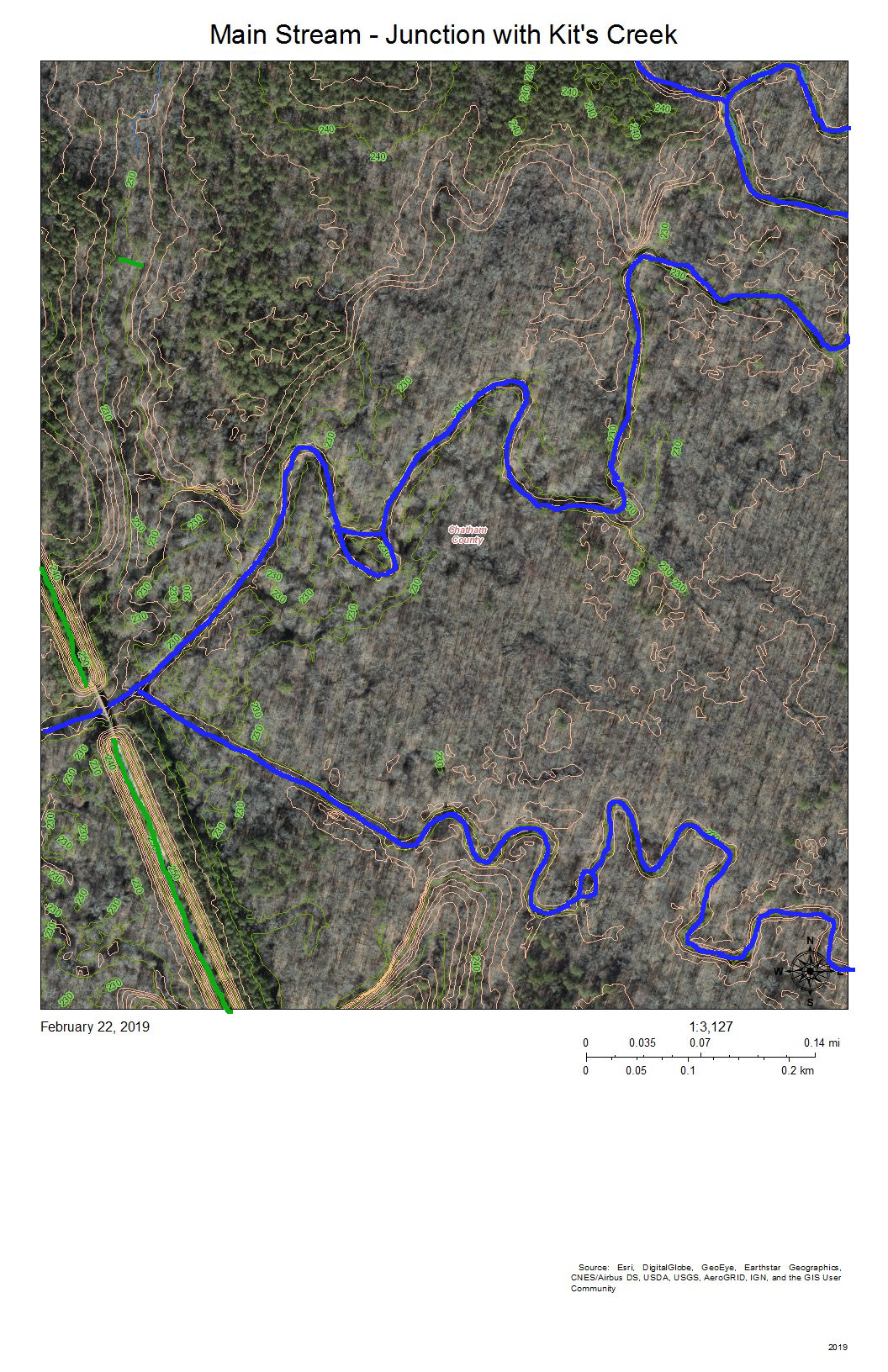
Main Stream Junction with Kit’s Creek
The green line at the bottom right is the Rails-to-Trails American Tobacco Trail (ATT) that runs from the Durham Bulls Athletic Park to the village of New Hill in Wake County. The gap is just to allow the bridge over the Northeast Creek to be visible.
Kit’s Creek (Kitt’s Creek is also correct) flows from the southeast and joins the main stream of Northeast Creek right before the ATT bridge. This junction is in Chatham County.
The area to the north of Northeast Creek is bottom land hardwood forest that includes some magnificent beech trees and shagbark hickories.
This entire floodplain down to the rookery at the mouth by the NC 751 bridge is owned by the Corps of Engineers and administered by the NC Wildlife Commission as gameland.
Another fun activity is to see where your water goes when it leaves the Parkwood area. A great way to explore this part of Northeast Creek is to hike or bike on the ATT; an alternative is to park at the parking lot by the NC 751 bridge, put in your kayak in the bay to the east and paddle upstream as far as you can (generally short of Panther Creek because of beaverdams and blowdowns).
Creek Week is coming March 13 through 20. During that week Durham is focusing attention on how individual citizens and property owners can with modest efforts deliver significant benefits to the quality of water moving downstream, especially to Jordan Lake.
A fun activity during Creek Week is to find the path that water from your roof, sidewalk, driveway, and patio or deck takes as it goes to Northeast Creek, down Northeast Creek and into Jordan Lake, and down the Cape Fear River to Wilmington.
Sub-basins of Northeast Creek in the Parkwood area
To do that, we must perceive streams and their tributary flows of runoff in the foreground and land in the background. Focusing on the flash flood zones at full flood (the flood zones identified on the Sub-basin map) shows the land as necks extending into the fully flooded lake headwaters. After all, one of the primary purposes of Lake Jordan was mitigation of the flash flooding that often occurred in the Haw River and New Hope Creek basins.
We see that Parkwood comprises parts of three sub-basins:
The main stream of Northeast Creek on the east;
Tributary C feeding Parkwood Lake in the center;
Tributary D draining the western part of the McCormick high land and streams from Hunters Woods joining and running down Wineberry to the west.
To find out which sub-basin you are in, find where your house is on the map.
For reference, look for these landmarks:
Parkwood Elementary School
Parkwood Fire Station
Gas House Shell Station
South Durham (SoDu) Farmers Market at Greenwood Commons.
Click on the image of the map. Use Ctrl-+ to enlarge the map. Now look for the landmarks.
Now trace the path the water takes from your house to the main stream, Tributary C, or Tributary D.
Are any streams by your property?
Which sub-basin do they flow into?
Where does the runoff from your house enter a stream?
Does it flow through a stormwater drain or stormwater pipe? Where does the water drain into a stream?
Does it flow down intermittent creeks that only have water when it rains?
A fun activity is to put on your rain gear when it rains and follow the water where it flows until you locate the storm drain and stream into which the runoff flows.
Save the date: Clean Water for the Triangle – How to Take Action, Monday, March 19, 2018, 6:00 PM 8:00 PM, Lowes Grove Middle School (map.) A talk with the Haw Riverkeeper and local advocates about threats to local watersheds and ways to defend safe drinking water for all. Register
Here are the tips to get spring off to the best of the Northeast Creek watersheed.
Watch the arrival and departure of spring ephemerals. 11 Spring Ephemerals Native to Lake Lure and Hickory Nut Gorge Lake Lure is in the mountains of Rutherford County, NC, between Rutherfordton and Asheville. How many of these same spring ephemeral flowers show up in the wetlands and uplands of the Northeast Creek basin some 220 miles along I-40? Check out the James Pullman Photos and the David Carter Photos on this site to get some clues to where they typically appear.
Identify the erosion and drainage issues to address in your yard this year. Durham Soil and Water District: Community Conservation Assistance Program A key partner in Northeast Creek Streamwatch’s Upsteam Neighbors/Downstream Neighbors watershed improvement program using individual porperty-owner initiatives.
Look for ways to save first inch of rainfall on your property during each rainstorm. Another piece of the Upstream Neighbors/Downstream Neighbors program for which Durham Soil and Water District can provide free consultation to homeowners. Durham Soil and Water District: Community Conservation Assistance Program
Gather your neighbors to walk and clean your roadway of litter.
Come and talk to us at the Northeast Creek Streamwatch tent at the South Durham (SoDu) Farmers Market Saturdays 9am-12noon at Greenwood Commons (NC 55 and Sedwick)
Attend Clean Water for the Triangle – How to Take Action, Monday, March 19, 2018, 6:00 PM 8:00 PM, Lowes Grove Middle School (map.) A talk with the Haw Riverkeeper and local advocates about threats to local watersheds and ways to defend safe drinking water for all. Register
For more information contact colleen@northeastcreek.org.
It is time to save the dates again for Durham Creek Week. During Creek Week, Northeast Creek Streamwatch is encouraging volunteers to come out in neighborhood groups just to discover their local stream, explore it, clean it of litter or bulkier items. Northeast Creek also encourages volunteers to explore the wetlands that form the boundaries between many of our neighborhoods.
To participate in official Northeast Creek Streamwatch events, contact Colleen Haithcock (colleen@northeastcreek.org) to register. Also visit us at the South Durham Farmers Market during March.
Northeast Creek Streamwatch has been cleaning up locations on the creek since 2006; we have been participating in the Durham Creek Week clean-ups since 2009. Creek Week is a time to discover and clean up our local streams. It has been celebrated in Durham since 2009, with 1,937 volunteers collecting 117,270 pounds of litter to date.
Durham Creek Week 2017 will have events from March 17 through March 25. Save the dates now for the events that interest you and your family from the list of Durham-wide events..
Northeast Creek System
The Northeast Creek watershed drains the southeastern part of Durham County, the northeastern part of Chatham County and the western part of Wake County. Water from Northeast Creek flows into Lake Jordan at the NC 751 bridge and from there down the Haw River to the Cape Fear River and out to the Atlantic Ocean at Cape Fear, south of Wilmington. If you live south of Glover Road or Riddle Road in Durham and between Fayetteville Road and Miami Boulevard in Durham County, or east of NC 751 and north of New Hope Church Road in Chatham County, or north of Green Hope Road and west of NC 55 in Wake County, you likely live in the Northeast Creek basin.
So find your location in your watershed, gather up some friend, family, neighbors, and co-workers, and schedule a creek clean-up for Durham Creek Week. It’s a great way to welcome spring!
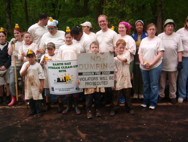
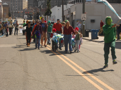
Barry Archer as Creek Critters fox in the 2014 Parkwood Christmas ParadeIn March 2014 Northeast Creek Streamwatch participated in the Durham Creek Week stream clean-up by cleaning the banks of the creek that flows into the Parkwood lotus pond and lake. In preparation we had advertised in several local businesses. We set up a table with a banner announcing a creek clean-up, and people came out to participate. Among the folks who helped were several youth, one of whom rode by on his skateboard and went home to change and came back to work. Several of the youth belonged to a local youth group and asked if their youth group could do a another clean-up as they were looking for service projects..These youth were participants in a community leadership training program facilitated by Barry Archer of Barak Source for Learning; they came to the next monthly meeting of Northeast Creek Streamwatch and invited our group to meet with them.
As a result of that meeting, Northeast Creek Streamwatch collaborated with Spring Break enrichment program by locating a speaker from the Ellerbe Creek Watershed Association, who spoke about urban creek runoff and the problems of erosion and non-point-source pollution. The group then conducted two days of clean-ups and learned about the hydrology, plants, and animals of a section of Northeast Creek that included blooming paw-paws and spring ephemerals. This section includes meanders and oxbow ponds, which are normal flood plain features in the geography of the Durham Triassic Basin.
In December 2014, this youth group marched as part of the Northeast Creek Streamwatch unit in the Parkwood Christmas Parade, wearing costumes of a great blue heron, deer, and other creek critters.
In January 2015, this youth group helped make costumes of other creek critters in preparation for the Durham Creek Week kickoff parade. In March 2015, they marched as herons, frogs, and other creek critters in the parade. Adult facilitators and parents of the youth marched as a fox, a leaf and ladybug, an opposum, and a beaver.
The leader of this group Mr. Barry Archer trains the youth in leadership skills, and we have been very impressed with the ability of the youth to volunteer and seek out opportunities for service on their own.
Northeast Creek Streamwatch takes this occasion at the end of a summer program put together by Mr. Archer and Mr. John Apel to thank them for their continuing collaboration with the efforts of Northeast Creek Streamwatch and to the greater Parkwood community. We also thank the youth who have been involved in these several programs for their hard work in cleaning up Northeast Creek and their willingness to learn the science, technology, engineering, and math (STEM) skills involved in the creek and its care.
Frog leads the parade as the Bulltown Strutters strike up the band
Four of the Creek Critters
Rapt audience at the Creek Critter Puppet Theater
The 2015 Creek Week Kickoff at Durham Central Park on March 21, 2015 saw the creek critters from Northeast Creek march in the parade with people from the other watersheds in Durham County.
One of the highlights of the event was the Northeast Creek Critter Puppet Theater featuring Woodrow the beaver and Clyde the raccoon and puppeteers Barry Archer and John Apel.
This is an article I wrote for the February issue of the Parkwood Inside/Out. We are planning trash cleanups on March 28th and a hike, and will be participating in the costume parade downtown on March 21st and other events for Durham Creek Week 2015. Check this website for announcements and all events will also be posted at:
Red maples dotting the still bare landscape with blots of crimson are one of the first signs that spring is here, but elms are among the first trees to flower. These prominent trees might be less appreciated because an elm in flower is stormy grey or lime green. Winged elms are the most common species, especially in central Parkwood, but there are slippery elms along the streams and probably American elms, and there are scattered Eurasian ornamentals. The most prominent and beautiful elm I know of in the area is the classically fountain-shaped tree on Highway 54, across from . Because its limbs are all high above the ground, it is hard to identify the species.
Elms, especially American elms, are beloved for the fountain or vaselike shape of mature trees, and there is a graceful symmetry to elms generally. Their leaves and branches alternate, creating an airy lattice effect. The straight veins in their oval leaves, double toothed like a pruning saw, are straight and parallel, but elms also have a very unsymmetric feature – the leaf bases are lopsided, especially in American and slippery elms. Elms have thin, elegant branches, strengthened by very tough wood, and the bark of some species can be twisted into rope. They produce wind pollinated bisexual flowers in early spring, developing into small seeds with a circular flange that drift with the wind several weeks later. The elms generally like moist soil, but winged elms seem to grow in drier soil as well.
The massive, spreading elm in front of Carrboro’s Town Hall could be an American elm (it is big enough for a plaque, yet nothing identifies the species), and I think there are labelled American elms in the Coker Arboretum at UNC. American or white elms are around, but are less common after the arrival of Dutch Elm Disease, a fungus that came to the US around 1930, and is spread by introduced and native beetles that bore in elms. Many elms have been killed, especially American elms, but this seems to be a little less catastrophic than the introduction of chestnut blight and emerald ash borer beetles, and the disease can be managed. American elms are large trees with furrowed bark, brownish leaf buds, and their leaves and stems aren’t very hairy, or less so than slippery elms. Their seeds have some hairiness, while the seeds of slippery elms lack hairs. Both American and slippery elms have large, sandpaperlike leaves, but American elms have greenish flowers, unlike slippery elms. Because their wood is so strong and resistant to splitting, and grips screws tightly, American elms have been used to make things like sports equipment, boats, flooring, crates, and kitchen cutting blocks. Many were planted for landscaping in the northeast, though they grow throughout the eastern USA. In A Natural History of Trees, botanist and nature writer Donald Culross Peattie wrote “If you want to be recalled for something that you do, you will be well advised to do it under an [American] Elm – a great Elm, for such a tree outlives the generations of men; the burning issues of today are the ashes of tomorrow, but a noble Elm is a verity that does not change with time. And although Elms too are mortal, great ones are remembered as long after they are gone as are great men.”
Slippery elms are similar to American elms, but smaller and less vaselike. They have been called red elms, having hairy, reddish leaf buds and reddish flowers, as well as hairy twigs. Their inner bark is slippery and becomes mucouslike when chewed. This inner bark was used to make tea and flour and was used for a variety of internal and external problems and still has an FDA approved medical use. American elm bark was used medicinally by Native American groups.
Winged elms are named for the cork flanges that line their twigs to varying degrees. Sweetgums usually aren’t as winged as elms and their leaves are very different. Winged elms leaves are smaller, smoother, and more symmetrical than those of other elms, and large trees have light brown bark. I think these are the first elms to flower, with brownish flowers that turn into silvery, hairy seeds. As with most trees, winged elms grow a lot when they first leaf out in spring, delicately etched leaves surging forth from the twig tips at a fast clip. The tiny, silky looking new leaves hang as if limp, but are actually strangely stiff. Snow, ice, and maybe hurricanes smashed many of the spindly young loblollies behind the Fire Station around 2002, leaving winged elms, ash, and a few surviving pines as the dominant tall trees, to be replaced themselves by oaks, hickories, and beech in coming decades.
Many animals chew on elm branches, leaves, and seeds, including opossums, rabbits, and bobwhites. The caterpillars that fed on elms are like a who’s who of moths and butterflies, including many of the moths you might see at your porchlights this spring. Double-toothed prominent moth caterpillars feed only on elms. They bite into a leaf and then rest there, so their jagged backs appear like the missing leaf edge. It is surprising that this camouflage works, since elm leaves are emerald green, but the caterpillars are pale seafoam blue and green.
Volunteers Preserving the Natural and Cultural Heritage of Northeast Creek