
Creek Week is coming March 13 through 20. During that week Durham is focusing attention on how individual citizens and property owners can with modest efforts deliver significant benefits to the quality of water moving downstream, especially to Jordan Lake.
A fun activity during Creek Week is to find the path that water from your roof, sidewalk, driveway, and patio or deck takes as it goes to Northeast Creek, down Northeast Creek and into Jordan Lake, and down the Cape Fear River to Wilmington.
To do that, we must perceive streams and their tributary flows of runoff (the water) in the foreground and land in the background. Focusing on the flash flood zones at full flood (the flood zones identified on the maps) shows the land as necks extending into the fully flooded lake headwaters. After all, one of the primary purposes of Lake Jordan was mitigation of the flash flooding that often occurred in the Haw River and New Hope Creek basins.
The coloring of the flood zones represent the following:
- Solid blue: 1% annual chance flood hazard
- Blue with red diagonal stripes: Regulatory floodway
- Gold: 0.2% annual chance flood hazard
- Black with gray diagonal stripes: Future conditions 1% annual chance flood hazard.
A previous post showed that Parkwood comprises parts of three sub-basins:
- The main stream of Northeast Creek on the east;
- Tributary C feeding Parkwood Lake in the center;
- Tributary D draining the western part of the McCormick high land and streams from Hunters Woods joining and running down Wineberry to the west.
This post presents maps to help find the path that the water takes from the roof of a particular house to Tributary C of Northeast Creek, which feeds the Parkwood Lake. Future posts will look at Tributary D and the main stream of Northeast Creek.
Skim through the maps to the part of Tributary C that you want to examine and then click on the map to enlarge. To enlarge further use the + keys in your viewer or Ctrl-+ on the keyboard. There will be some street references in the text following each map.
Yellow lines mark the sub-basins of Tributary C. Blue lines are the creeks in the area in the map title. Dotted blue lines are intermittent creeks inferred from the topography or known significant stormwater pipes. The impervious surfaces of roofs are orange, and the impervious surfaces of parking lots, driveways, and other concrete structures are gray.
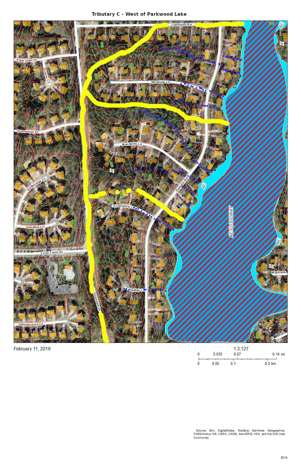
Looking from the mouth of Tributary C and Northeast Creek, the sequence of maps examines each upstream branch and the main stream of Tributary C back to its source near NC 54.
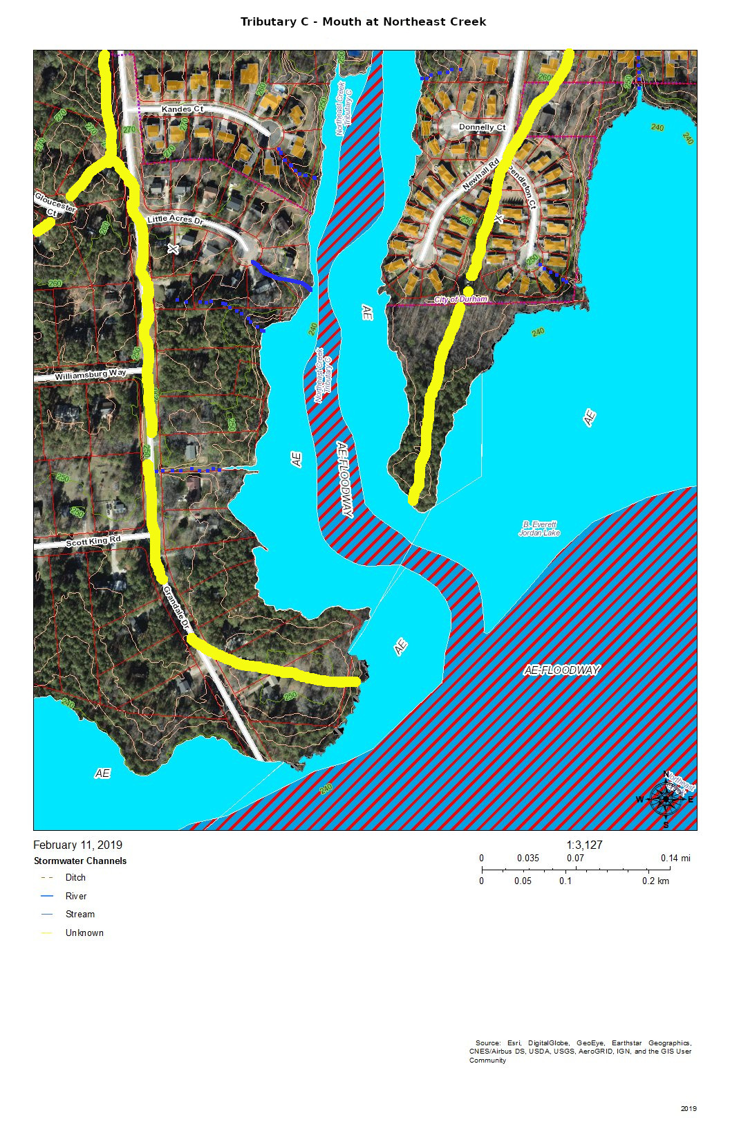
The mouth of Tributary C is a wetland flood plain that cycles between swamp forest in drier times and then snags (dead trees that are habitat for wildlife) and freshwater marsh in wetter times. You can see this same sort of landscape on the north side of NC 54 by Woodcroft Shopping Center.
Runoff from the roofs and drives flows through the yards or down the streets to the cul-de-sacs and down slopes into the bottomlands.
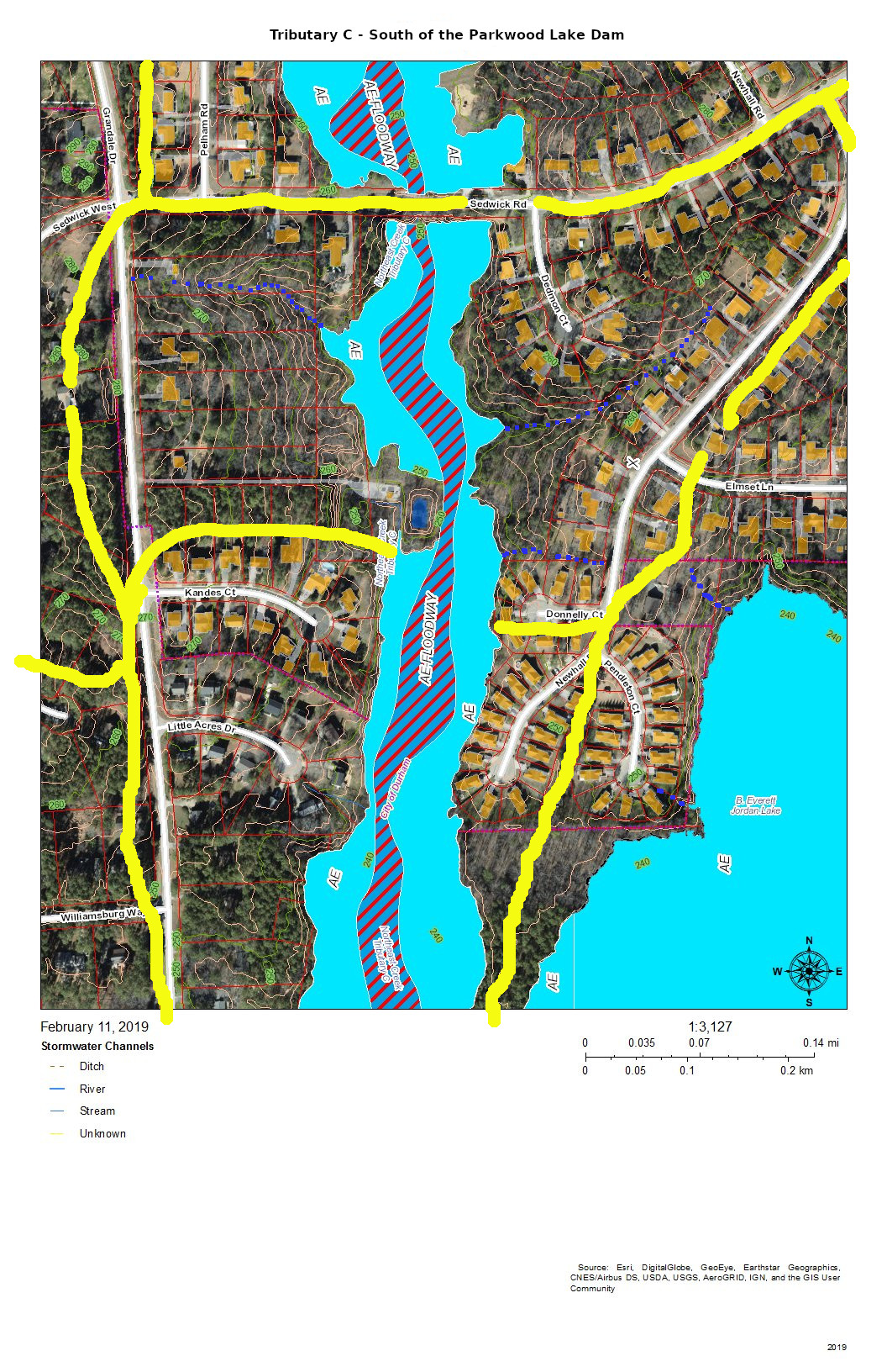
The main stream south of Parkwood Lake comes down the spillways from the lake through woods, under Sedwick Road, and into the bottomlands. An intermittent stream drains the runoff from the houses on Dedmon Court, Donnelly Court, Newhall Road, and Sedwick Road. An intermittent stream on the west side of the bottomlands drains the runoff from two houses on Sedwick Road and one on Grandale Road.
The runoff from the houses on the west side of Parkwood Lake primarily flows down the streets, across Pelham Road and into the lake. The runoff from the houses on lake flows directly into the lake.
The runoff from the east side of Grandale Road just north of Sedwick Road is directed into the ditch on the north side of Sedwick Road and is a part of this section of Tributary C.
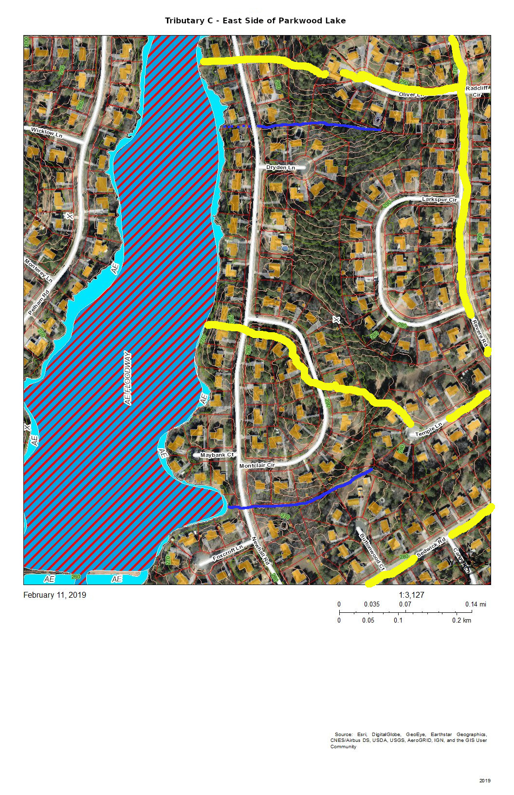
The east side of Parkwood Lake drains the west side of Revere Road and Larkspur Circle in addition to the houses along Newhall Road and the lakefront houses. There seem to be two more-or-less permanent streams draining from either corner of Larkspur Circle. There is significant Parkwood common land in the center of this block that aids in soaking up rainfall from Larkspur Circle and Revere Road. Another stream drains Temple Lane and Buttonwood Court.
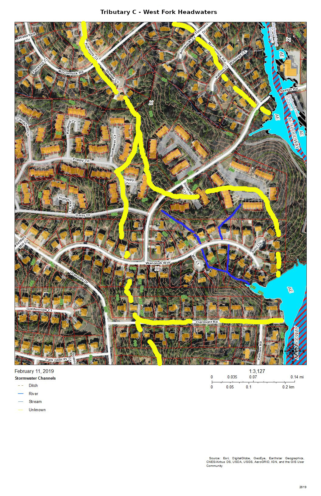
The west fork headwaters drain part of The Ridges of Parkwood, part of Parkwood Village, and some of the houses on Wenonah Way, Runoff from the west fork headwaters flow directly into the Parkwood Lake forebay (former lotus pond).
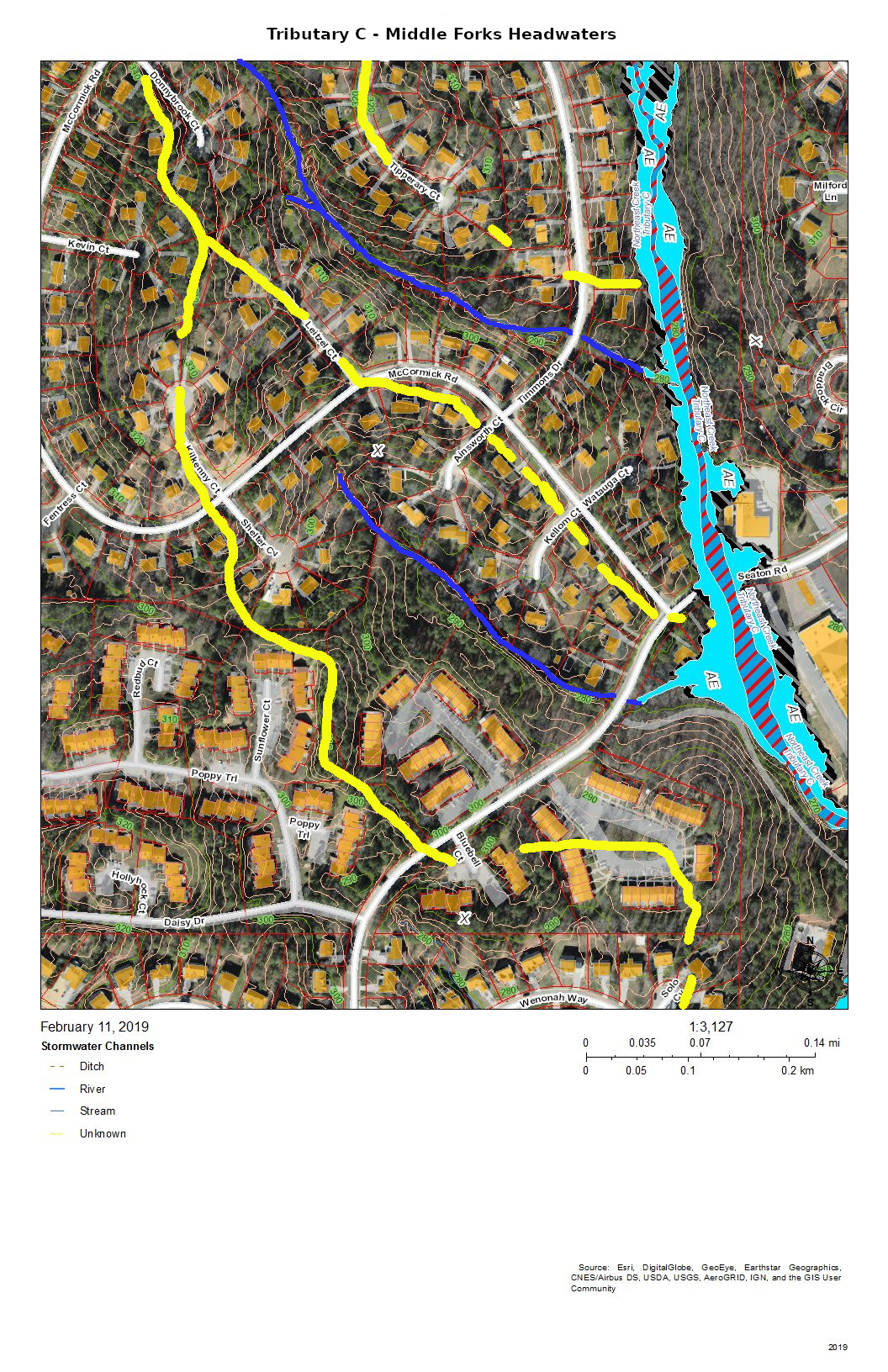
The headwaters of the two middle forks of Tributary C drain the southeast side of the McCormick Road highland. The southernmost of the two middle forks drains most of Parkwood Village.
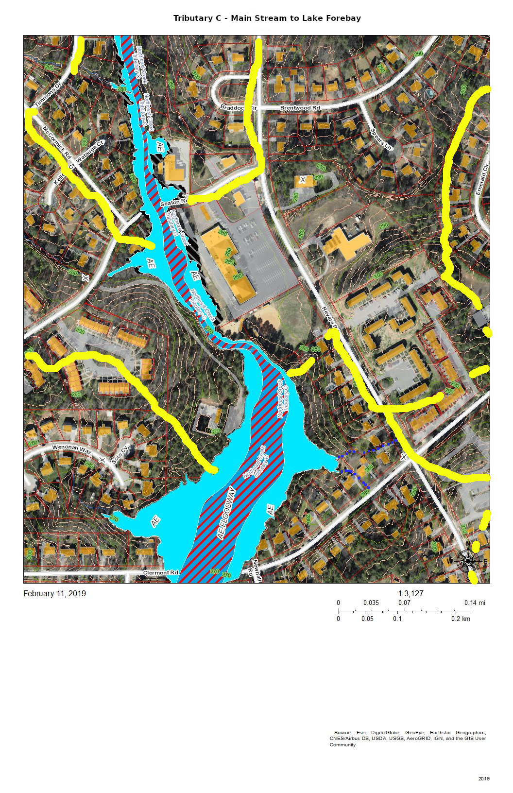
This section of Tributary C shows the main stream in the area of the trail from the Parkwood ballfield to the Parkwood Lake forebay (former lotus pond). The lower section is a significant bottomland that has a variety of interesting native plants such as magnolia, red maple, and native honeysuckle with hearts-a-bustin’, pussytoes, wild oregano, and lyre-leaf sage in the uplands.

The area of Tributary C east of Revere Road mostly drains through stormwater pipes the run under the parking lot of Jamaat Ibad Ar-Rahman mosque (former Parkwood Shopping Center). The stormwater pipes converge and empty through a single pipe outlet to Tributary C opposite Parkwood Village’s road to its swimming pool (the Pool in the Woods). This area drains from the hill on Brentwood Road near Bradley Circle and an area north of Brentwood Road almost to Travis Circle. It also drains the slope behind Parkwood United Methodist Church and the apartments up to the parcel that was set aside in the original design for a water tower and conveyed in that designation to the Parkwood Association. (In 1961, there were no city water and sewer services this far out. The Parkwood subdivision had a private utility that provided water from wells and owned and operated the package sewage plants.)
This elaborate stormwater system is the legacy of the philosophy of controlling stormwater that was prevalent at the beginning of the 1960s — pipe it away. The site preparation for “Parkwood Center”, the commercial and institutional core of the community froze some of the original stream system into the landscape while concentrating the flow under parking lots into a single stream. The object was to dump the excess water as fast as possible into Tributary C. After almost sixty years we can see that that strategy leads to stream scour and transportation of soil down the creek system. And creates erosional undercutting of the stream bank opposite the single stormwater pipe outlet.
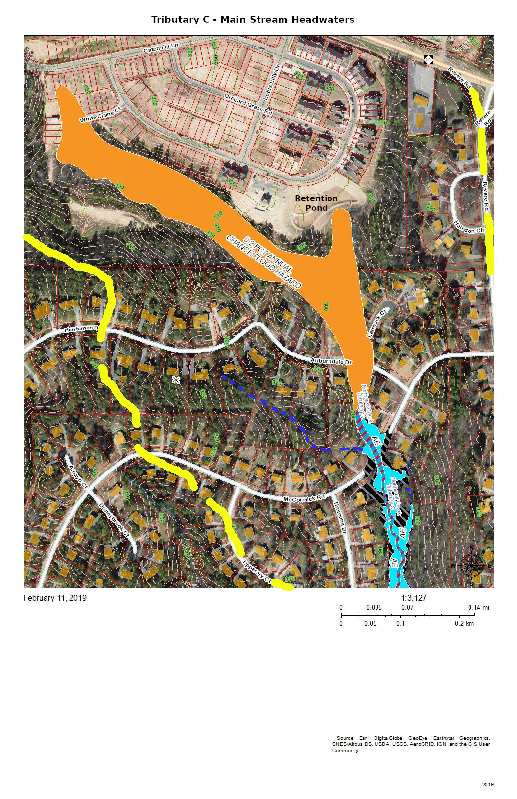
The headwaters of Tributary C lie completely south of NC 54 because NC 54 was built on a ridge between two tributaries of Northeast Creek and because subsequent engineering of the highway has sharpened the separations of the drainage. The headwaters now are developed as the Meadows at Southpoint, a town home community that uses regulation-permitted retention ponds instead of open space to manage run-off from its newly constructed houses, driveways, sidewalks, roads, and other impervious surfaces.
During construction, the Parkwood community experienced the fact that regulations are based on normal patterns of rainfall for construction of retention ponds. When there was a pattern of heavy rainfall, the retention ponds released sediments, particularly colloidial clay, into Tributary C; that turned the Parkwood Lake brown.
Residents in the Auburndale Drive-Lamarck Court area were among the first to notice the sediments because they monitor their nearby creeks.
In principle, with the completion of construction, the permanent retention ponds will prevent a recurrence. Continued citizen monitoring of their local creeks is the principal way of catching these situations early enough. And this is true for all of the streams draining into Northeast Creek.
That is why Northeast Creek Streamwatch is encouraging Upstream Neighbors/Downstream Neighbors, a volunteer program of monitoring neighborhood streams and conservation on your own property to harvest rainwater, conserve topsoil, and absorb water during abnormal rainfall.
Having attention on the portion of water flow from your house to the nearest creek is a critical part of what gets sent downstream.