Main Stream of Northeast Creek: Where Does Your Water Go?

Creek Week is coming March 13 through 20.  During that week Durham is focusing attention on how individual citizens and property owners can with modest efforts deliver significant benefits to the quality of water moving downstream, especially to Jordan Lake.

A fun activity during Creek Week is to find the path that water from your roof, sidewalk, driveway, and patio or deck takes as it goes to Northeast Creek, down Northeast Creek and into Jordan Lake, and down the Cape Fear River to Wilmington.

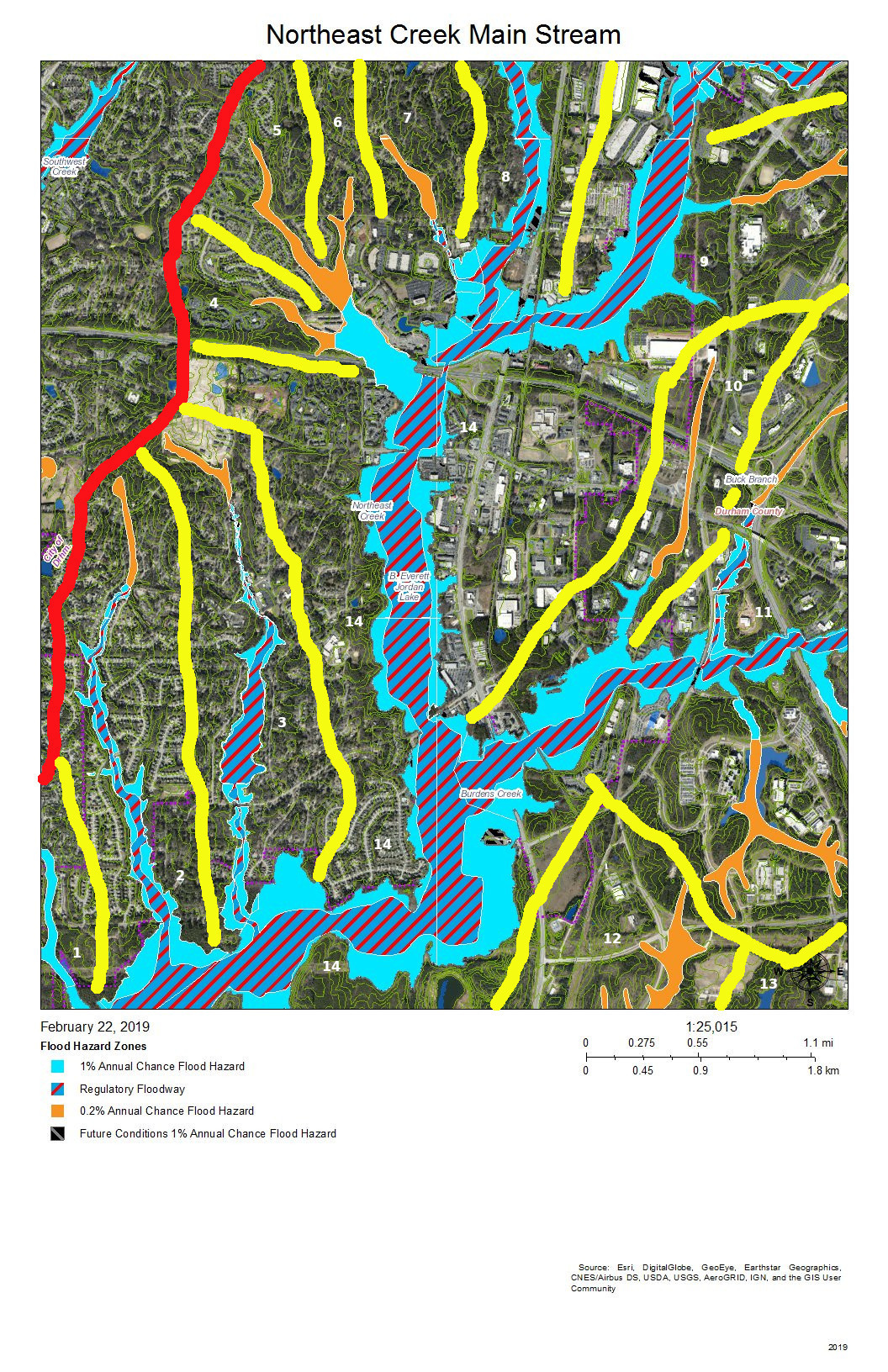
To do that, we must perceive streams and their tributary flows of runoff (the water) in the foreground and land in the background. Focusing on the flash flood zones at full flood (the flood zones identified on the maps) shows the land as necks extending into the fully flooded lake headwaters. After all, one of the primary purposes of Lake Jordan was mitigation of the flash flooding that often occurred in the Haw River and New Hope Creek basins.

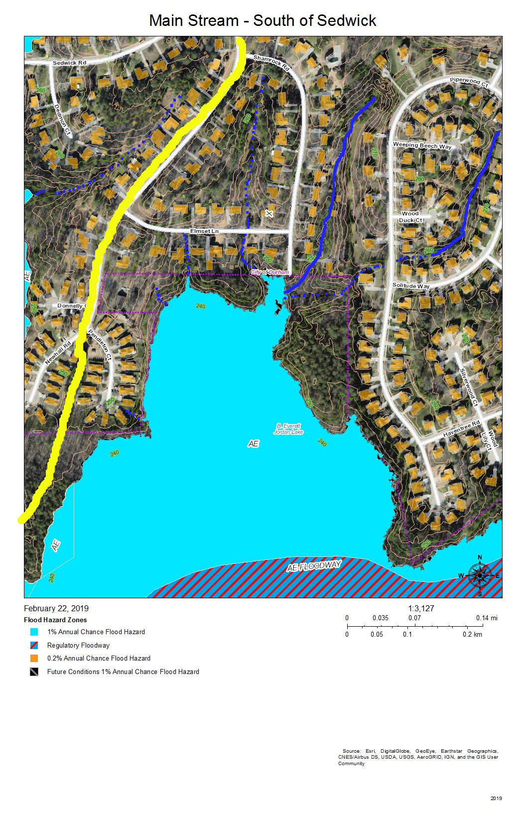
The coloring of the flood zones represent the following:

  • Solid blue: 1% annual chance flood hazard
  • Blue with red diagonal stripes: Regulatory floodway
  • Gold: 0.2% annual chance flood hazard
  • Black with gray diagonal stripes: Future conditions 1% annual chance flood hazard.

A second fun activity is to explore the wetlands on US Army Corps of Engineer land set aside for the headwaters of Jordan Lake.  The wetlands in these areas comprise:

  • periodic flood plains that flood with every rain and become dry land with every dry spell;
  • freshwater marshes;
  • periodic swamp forests;
  • persistent swamp forests that give way to snags (dead trees that host animals like woodpeckers) then become pools of blow-downs (blown-over dead trees);
  • tightly meandering stretches of stream;
  • braided streams;
  • oxbow ponds.

These organize themselves to best handle the flow of water through the wetlands in wet and dry periods.

On the maps, wetland features are marked with dotted blue and or‍ange lines.

A previous post showed that Parkwood comprises parts of three sub-basins:

  • The main stream of Northeast Creek on the east;
  • Tributary C feeding Parkwood Lake in the center;
  • Tributary D draining the western part of the McCormick high land and streams from Hunters Woods joining and running down Wineberry to the west.

This post presents maps to help find the path that the water takes from the roof of a particular house to the main stream of Northeast Creek and the features of the Northeast Creek wetlands that it passes through.  Future posts will look at what you can do on your own property to help preserve effective functioning of Northeast Creek.

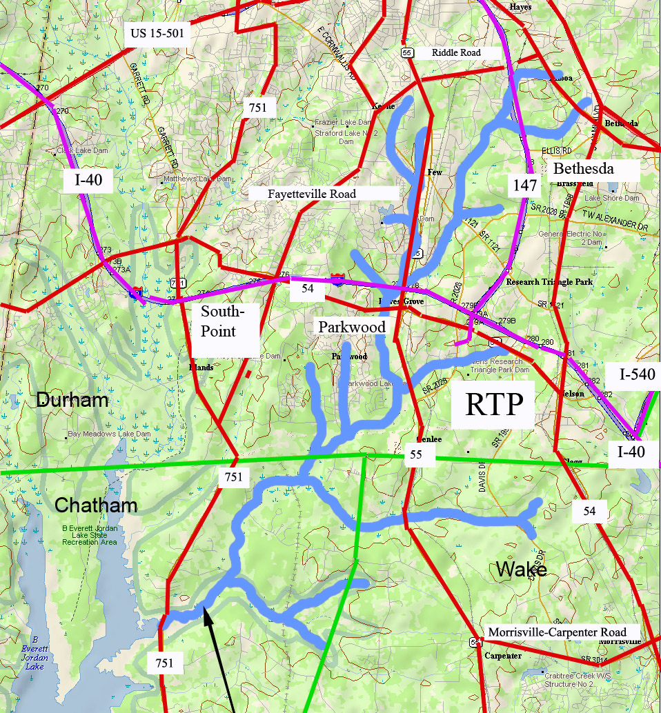
The following map is an overview of the Northeast Creek main stream from Carpenter-Fletcher Road downstream to the American Tobacco Trail bridge over Northeast Creek on the trail a half mile south of the Scott King Road trailhead.

The red line is the watershed ridge on the west between the Northeast Creek basin and the Crooked Creek basin.

An overview map of the tributaries of the main stream of Northeast Creek in the greater Parkwood area
Main Stream – Overview

From left to right the sub-basins of Northeast Creek are:

  1. A fork that arises in the Southhampton neighborhood and the edge of C. M. Herndon Park on Scott King Road;
  2. Tributary D;
  3. Tributary C;
  4. A tributary that runs from the Legacy at Meridian;
  5. A tributary that runs out of the Auburn neighborhood;
  6. A tributary that crosses Woodcroft Parkway east of Barbee Road;
  7. A tributary that flows into Meridian Park;
  8. The North Prong of Northeast Creek, the major tributary that flows down the west side of NC 55 and through Meridian Park;
  9. The main stream (Northeast Prong) of Northeast Creek;
  10. Buck Branch, which flow out of the old EPA campus area;
  11. The north fork, main stream, and south fork of Burdens Creek, which drains the central section of Research Triangle Park;
  12. Long Branch of Kit’s (Kitt’s) Creek;
  13. Another branch of Kit’s Creek, which drains the southern section of Research Triangle Park.
  14. Main stream of Northeast Creek.

This series of maps will show the western side (Parkwood side) of the main stream, that wide, blue and blue-and-red floodway that:

  • starts at the top right of the map,
  • flows south,
  • then west again in passing the Red Roof Inn on NC 55 north of I-40 and connecting with the North Prong in the southeast corner of Meridian Park,
  • then south again at the Doubletree Inn;
  • then it crosses under I-40 and flows through a wetland between Parkwood and NC 55;
  • Burdens Creek joins it from the east and Research Triangle Park;
  • then turns west flowing south of Audubon Park and Parkwood,  through Corps of Engineers unforested land and a Duke Energy high-voltage line easement;
  • then it crosses under Grandale Road passing through forested Corps of Engineers land (NC Gameland);
  • it crosses into Chatham County;
  • Kit’s Creek joins it from the southeast and the southern part of Research Triangle Park;
  • it flows  under the bridge for the American Tobacco Trail, a bicycle and pedestrian trail.

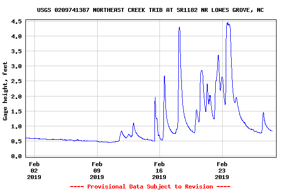
There are two stream gages placed by the US Geological Service on this section of Northeast Creek, one at Carpenter-Fletcher Road and the other at the bridge on Grandale Road. To provide a view of what this section of the main stream does, here is the February 2019 stream gage data for the Carpenter-Fletcher Road gage.  Notice that the level during moderate periods is around 0.5 feet (6 inches), but rain quickly causes the level to rise to 2, the 2.5, then 4.5 feet.  Remember these numbers when we come to the data from Grandale Bridge.

A graph of the depth of the North Prong of Northeast Creek at Carpenter-Fletcher Road during the rainy month of February 2019
Stream Depth North Prong of Northeast Creek at Carpenter-Fletcher Road – February 2019

That stream gage is just upstream (north) on the North Prong (out of view off the top of this map).

A map of the development around the junction of the North Prong of Northeast Creek with the Main Stream in the Meridian Park office park
Junction of the North Prong of Northeast Creek with the Main Stream

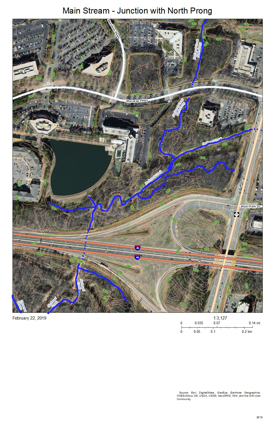
The North Prong drains the Northeast Creek watershed south of Riddle Road and southwest of the intersection of Riddle Road and Alston Avenue.  When it enters Meridian Park it flows into a wetland between NC 55 and Meridian Parkway (top right on the map).

The development and drainage into the main stream of Northeast Creek north of the NC 54 bridge
Main Stream of Northeast Creek North of the NC 54 Bridge

I-40 appears at the top right of this map.  The dotted blue line on I-40 is roughly where the culvert for Northeast Creek goes under I-40 and spills into the flood plain to the south.  At the left end of NC 54 on the map is Christus Victor Lutheran Church; at the right end is Chik-Fil-A.  The bridge is where the wetlands on the north side of NC 54 spill through to the south side of NC 54.  This area regularly has high water during rainy spells.

Almost all of this wetland area except for the various stream channels is a wide intermittent flooded area during rainy spells.  Drier weather allows for plant succession until water collects so frequently in those areas that it drowns out vegetation or gets replaced with water plants.

A map of the development and drainage into the main stream of Northeast Creek north of Euclid Drive.
Main Stream North of Euclid Drive

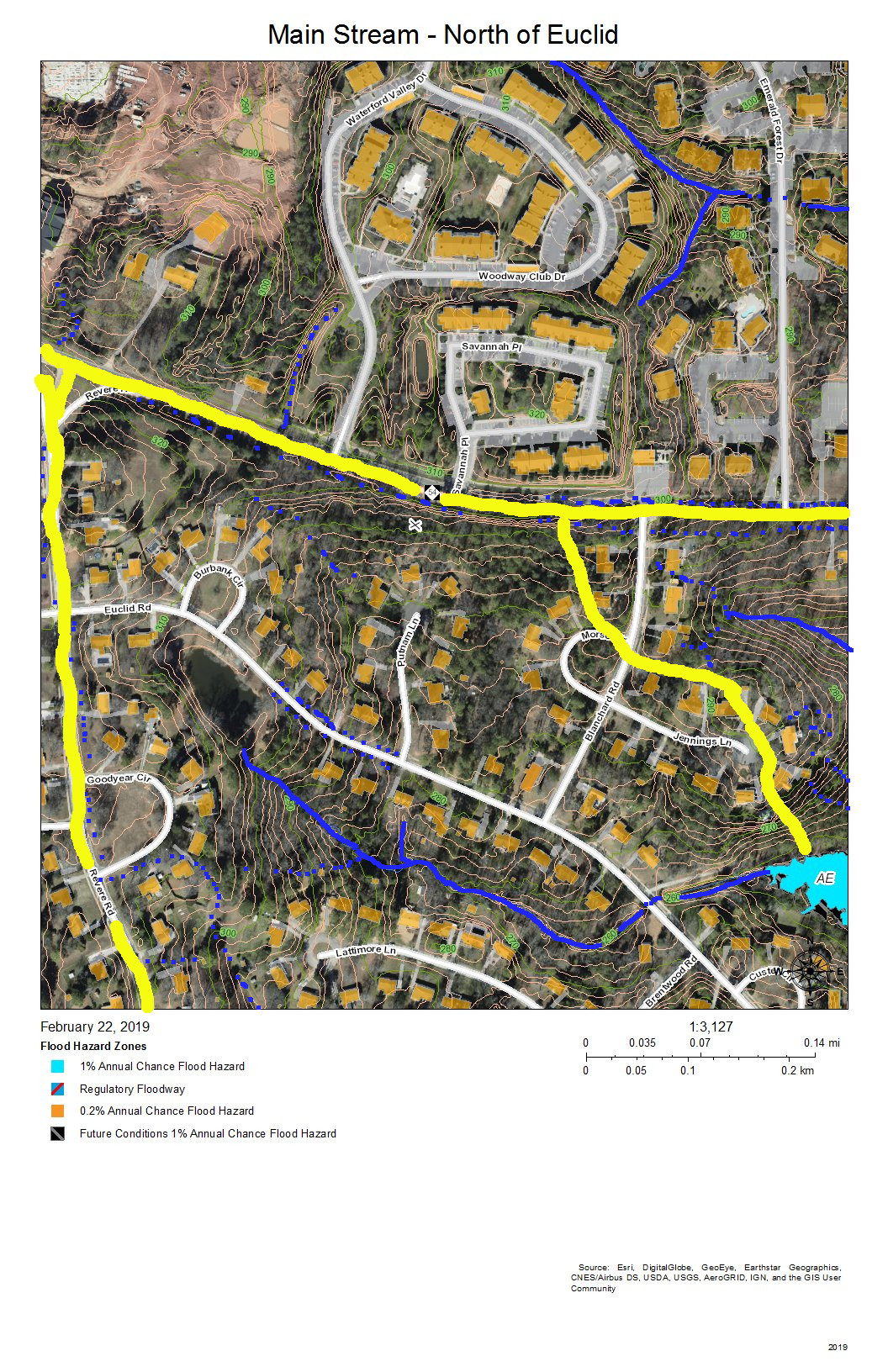
The drainage of the sub-basin north of NC 54 gets directed parallel and south of I-40 and flows into the wetlands south of I-40 and north of NC 54 (in the previous map).  The sub-basin on the top right has a stream that flows from the intersection of Blanchard Road and NC 54 southeast into the engineered pond behind the commercial buildings on NC 54.  The third sub-basin flows out of the pond at the Revere Road end of Euclid Drive, between the houses on Lattimore Lane and Euclid Road, under Euclid Drive at the bottom of the hill, and down a restored stream that replaced a culvert and into the main stream of Northeast Creek in the wetlands.

A map of the development around and drainage into the main stream of Northeast Creek north of Emerald Circle
Main Stream North of Emerald Circle

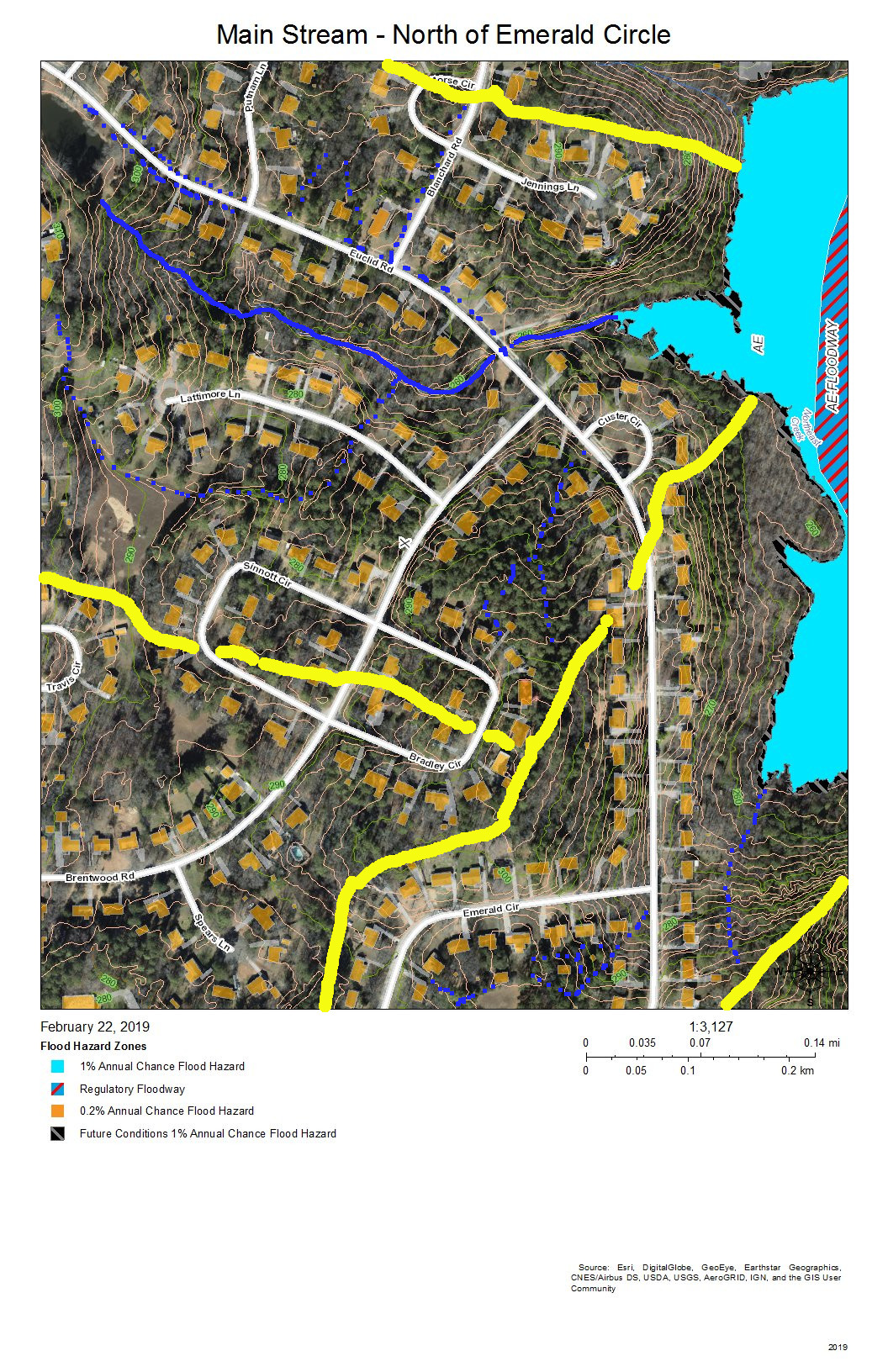
The sub-basin at the top shows the drainage into the creek that flows from the pond at the Revere Road end of Euclid Drive and the creek that crosses Euclid Drive along the road to the former package sewer plant location (when Parkwood contracted its own private water and sewer service).  The sub-basin at the bottom left is the area on Brentwood Road that flows into Tributary C.   The remaining sub-basin is the intermittent stream that drains Emerald Circle.

A map of the wetlands on the main stream of Northeast Creek behind the Food Lion store
Main Stream – Behind Food Lion

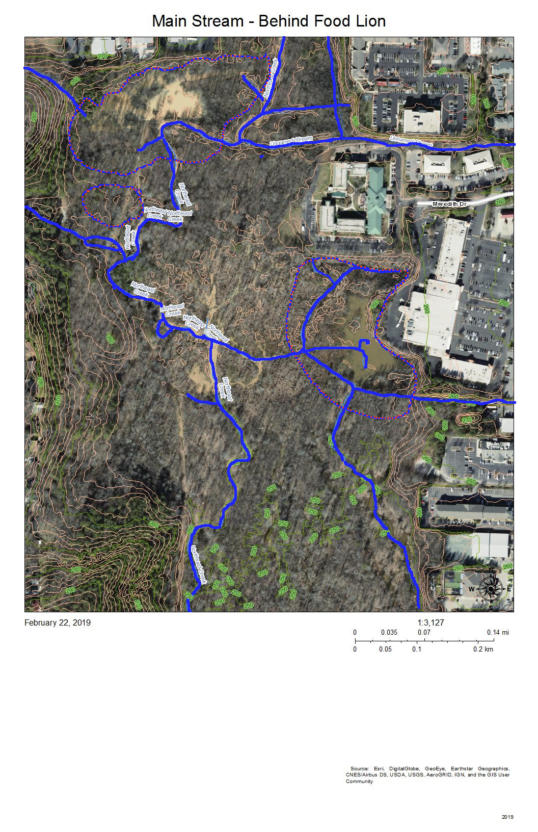
The complex pattern of blue lines (stream channels) on this map shows the effects of a strongly meandering and braiding Northeast Creek and the engineered attempts to reduce flooding of the parking lots of the properties backing up on the wetlands.  All of the water from the parking lots built on what used to be farmland adjacent to bottom land instead of somewhat soaking into pasture or woodlands, now all flows into the wetlands. Commercial property owners nationwide are only now beginning to investigate how to better manage stormwater on commercial properties.  Local governments have mandated certain best management practices for stormwater management over the last ten to twenty years.  The most obvious of these to most customers are the retention ponds on the edge of commercial developments.

The blue and orange dotted lines encircle areas of open water in the areas behind the commercial properties on NC 54 and the Food Lion shopping center on NC 55.

A map of the development and drainage of the main stream of Northeast Creek north of Parkwood Elementary School
Main Stream – North of Parkwood Elementary School

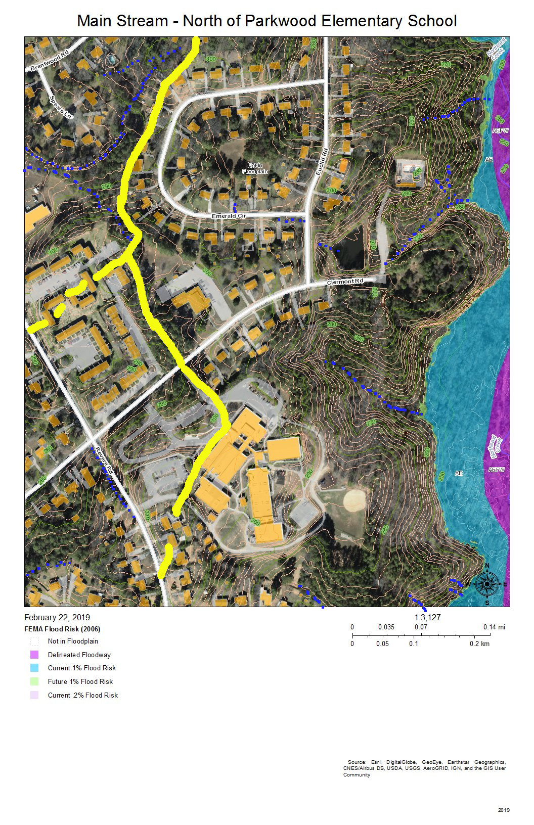
The sub-basins to the left of the map drain into Tributary C (Parkwood Lake).  Parkwood Elementary School has engineered stormwater management of its site.  The houses on Radcliff Circle drain down the vegetated ground cover of the buried sewer outfall to the main sewer line that goes to Triangle Wastewater Treatment Plant on NC 55.

A map of the main stream wetlands behind the NC 55 commercial area and north of Greenwood Commons
Main Stream – North of Greenwood Common

As the intensity of commercial development on the eastern edge of the wetlands diminishes and as the force of flooding during rainstorms is absorbed by the size of the bottomlands, there are fewer engineered channels and the channels go from braided to parallel meanders.  The blue lines show stream channels; the blue and orange dotted lines show the perimeter of the more permanent swampy and marshy areas toward the eastern edge.

At the bottom of the map behind Greenwood Commons, the eastern side is a cattail marsh with a few snags. This marsh has been flooded by a natural dam of crushed branches and cattail stems that elevates the water impounded slightly above the western branch, which has a series of meanders.  The two branches join shortly before the main stream passes under the bridge on Sedwick Road.

A map of the development around and drainage into the Main Stream east of Revere Road and north of Sedwick Road.
Main Stream East of Revere Road and North of Sedwick Road

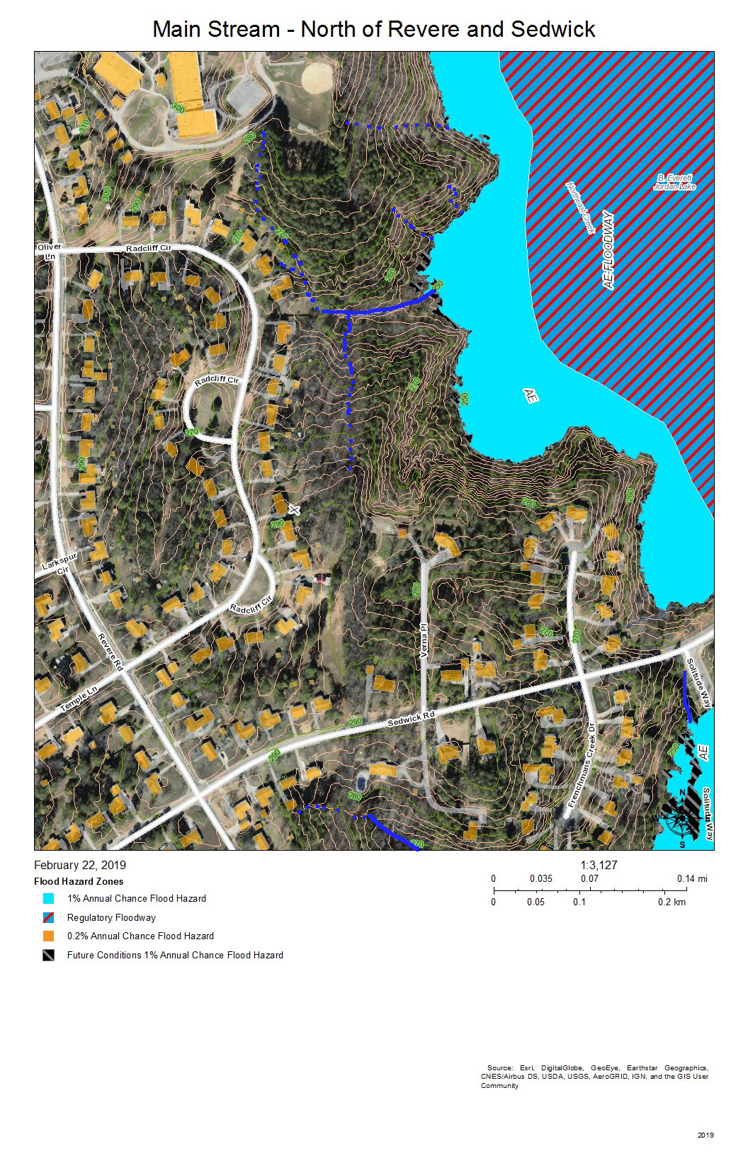
The primary drainage between the heights at the Parkwood Elementary School building and the short ridge on which Frenchman’s Creek Drive is built is the grassed sewer line easement (solid blue line) that runs from Radcliff Circle back to the main sewer outfall easement in the wetlands; both of these easement are somewhat wet from unevaporated stormwater except in very dry periods because of the intermittent streams (dotted blue lines) and groundwater flows that allow what rainwater that does soak in to be delayed in adding to the stream flow.

Water runs off the impervious surfaces, such as roofs (orange), driveways (gray), and streets (white).  The runoff that comes through the dark green forested area that have a lot of leaf litter moves much slower.  The water that does percolate through into groundwater move slower still.

The simple rules for managing rainwater on your own property are:

  • Slow it down.
  • Spread it out.
  • Soak it in.

This area shows how the undisturbed common land buffer on the steeper upland slopes between the individual house property and the wetlands carries out those functions.

A map of the wetlands and stream channels of the main stream of Northeast Creek on either side of the Sedwick Road bridge.
Main Stream at Sedwick Road Bridge

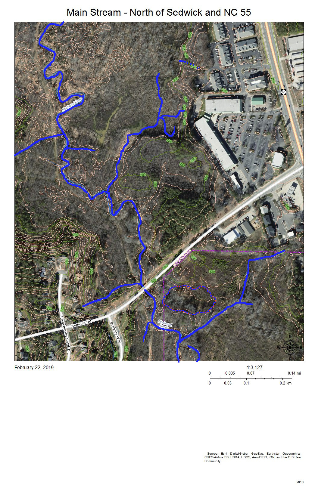
The blue lines show:

  • To the west, the meandering stream channels of the west branch of the main stream of Northeast Creek running just east of the sewer line easement that runs to the Triangle Wastewater Treatment Plant.
  • Coming in from the southwest, the tributary stream that has formed from the accumulated groundwater and runoff flowing from the heights of Parkwood Elementary School, Radcliff Circle, and Frenchman’s Creek Drive.
  • From the  marsh behind Greenwood Commons, the stream channel that has flowed nearest the commercial properties on NC 55.
  • The joining of the two meandering channels into the single Northeast Creek main stream
  • A tributary paralleling Sedwick Road and draining that part of Frenchman’s Creek Drive
  • The single channel of the main stream of Northeast Creek flowing under the Sedwick Road bridge.
  • Burdens Creek and its wetlands joining Northeast Creek from the east.
  • A north-flowing creek to the east of Solitude Way.
  • An oxbow lake just southeast of the junction of Burdens Creek and Northeast Creek.

The blue and orange dotted line encircles an area that became a intermittent pond after the property was logged.  The property is going through succession of vegetation and now is beginning to have small trees and forest sub-story beginning to grow.  Several years ago there was a cattail marsh in this wet spot.

You can also see some of the unmarked meanders, tributaries, and oxbow lakes as darker areas near the streams.

A map of the development near and drainage into the main stream of Northeast Creek at Audubon Park
Main Stream at Audubon Park

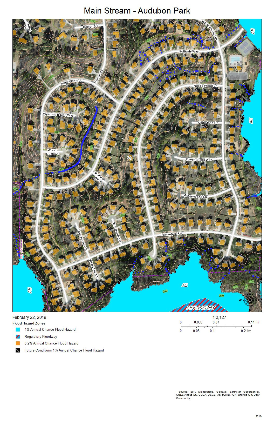
Audubon Park was developed with intensive site preparation and most likely stormwater pipes and structures to conduct runoff quickly into the wetlands to the east and south.  What appears on this map is a stream inside Piperwood Circle and Solitude Way.  There are also indications from the topography that intermittent streams might form with the slope of the ground and run off at the edges of the wetlands; after almost 20 years, there might be gullying at the edge of the wetlands (near where the blue dotted lines meet the color coding of the flood zones).  Homeowners in Audubon Park have the best view of how the water runs because so much of the drainage is enclosed interior to a bunch of houses and not visible by the public.

A map of the wetlands at the junction of Burdens Creek with the main stream of Northeast Creek
Main Stream – Junction with Burdens Creek

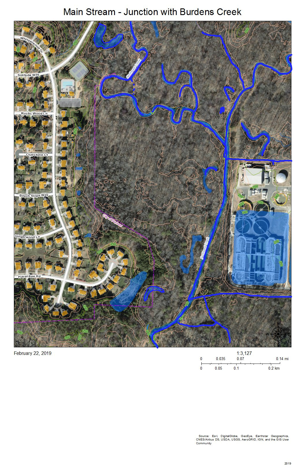
The wetlands east of Audubon Park show the meanders and oxbow lakes of intermittent flooding of bottomland forest in the area where Burdens Creek, coming in from the northeast, meets the main stream of Northeast Creek, meandering in from the north and making a eastward turn.  The Triangle Wastewater Treatment Plant  is at the lower right.

The processed wastewater coming out of the Triangle Wastewater Treatment Plant tests cleaner than the water in Northeast Creek at the outlet point.  Also, the volume of wastewater flowing through the Triangle Wastewater Treatment Plant cause a baseline oscillation of roughly 6 inches (0.5 feet) in the USGS stream gage at the bridge on Grandale Road of a typical dry-period stream height of 3.5 feet. (Notice this on the stream gage report at the end of this post.)

A map of the wetlands of the main stream of Northeast Creek south and east of Audubon Park
Main Stream – Bend to the West

The main stream turns to the west around the southeast corner of Audubon Park.  On the map, the development at top right is the back edge of the Triangle Wastewater Treatment Plant.  The blue lines are the meanders and loops of the main stream of Northeast Creek and the tributary streams that drain other parts of the wetland.

The area on the left marked with a blue and orange dotted line locates a former swamp forest, now characterized by snags and fallen trees killed by the persistent deeper water.

The two lines across the bottom are the high-voltage power line running from a substation on NC 55 to a substation on Scott King Road by the American Tobacco Trail.

This section is where Corps of Engineers ownership of the headwaters of Jordan Lake begins on Northeast Creek.

A map of the main stream of Northeast Creek south of Audubon Park
Main Stream South of Audubon Park

This view is slightly to the west of the previous view; the area of snags and fallen trees noted at the left of the previous view is in the center of this view.  To the left of this view is another swamp forest in decline.

A map of the development around and drainage into the main stream of Northeast Creek south of Sedwick Road
Main Stream – South of Sedwick

The yellow line is the headwaters ridge between the main stream of Northeast Creek and Tributary C of Northeast Creek.

The solid blue lines are the more permanent streams, and the dotted blue lines are the intermittent streams that drain the streets off Newhall Extension in Parkwood.

At the end of Shamrock Road is a triangular-shaped upland buffer of common land that faces out on a large freshwater marsh interrupted by some of the areas of flooded snags and fallen trees. Notice that the buffers between the newer developments and the wetlands are much narrower.

A map of the wetlands on the main stream of Northeast Creek south of Parkwood
Main Stream South of Parkwood

This is the same as the previous view but without the color coding for flood hazard areas.  The yellow line is the watershed ridge between the sub-basin of the main stream and the sub-basin of Tributary C of Northeast Creek.  The areas enclosed in blue and orange dotted lines are areas that are more permanently wet, such as snag areas, freshwater marshes, and open ponds. There is an area in the water at the end of Pendleton Court that is light green; this appears to be algae bloom.  Beyond it is a dark area of open water, and then the speckled area of the freshwater marsh.  Toward the bottom left is a dark open water area, enclosed with a blue and orange dashed line, in which fallen trees are clearly visible.  Within the marsh are thin, short slashed lines that are the shadows of standing trees. The open water through the marsh shows meanders that might show areas of faster flow.

On the bottom right is a 40-foot hill that forms a bluff at the southern edge of Northeast Creek.

All of the ricocheting of water in this wetland slows it down and allows it to spread across the low areas and soak in as best it can in the Triassic and floodplain soils.

A map of the wetlands around the main stream of Northeast Creek at Grandale Road bridge
Main Stream at Grandale Road Bridge

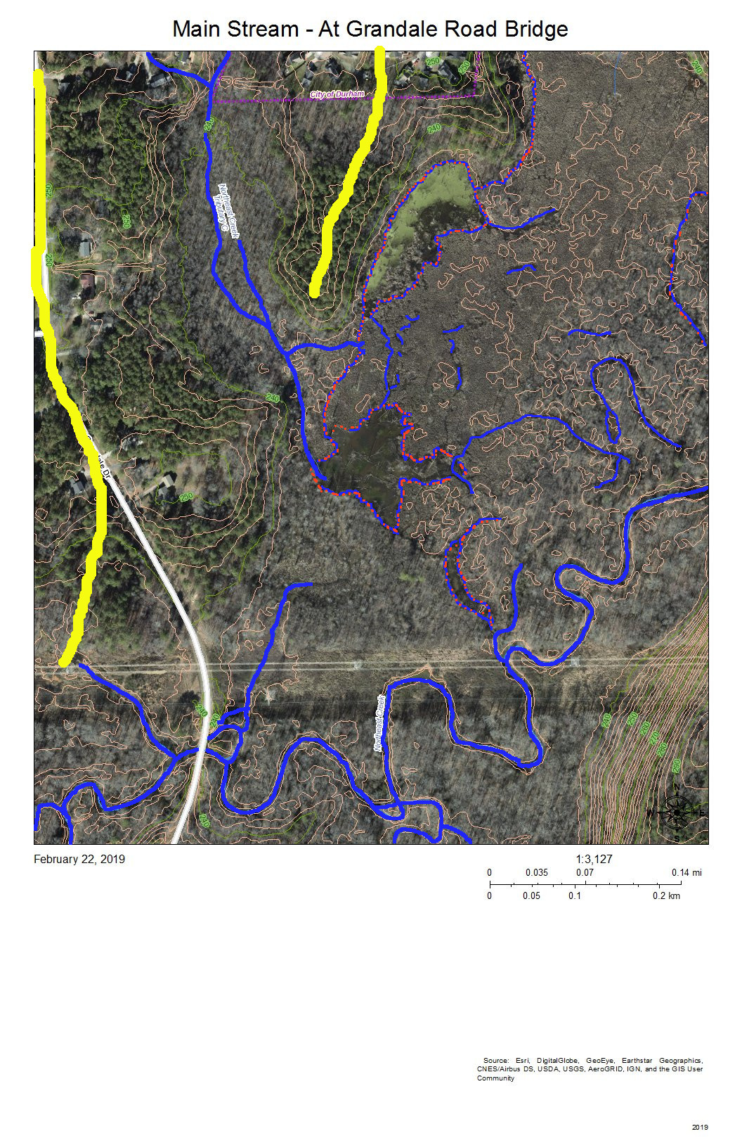
The Grandale Road bridge is just south of where the high-voltage power lines cross Grandale Road.

The yellow lines mark the headwater ridges that separate the sub-basins of, from east to west: the main stream, Tributary C, and Tributary D of Northeast Creek.

The features of the wetland north of the power lines are those we have discussed above.  This view shows more of the wetlands to the west and south.

The 40-foot hill turns out to be a 60-foot ridge that edges the floodplain on the south.  Almost all of the bottom land in this view is Corps of Engineers property marked as NC Gamelands.

The USGS gage station is on the bridge.  The following is the report from the month of February 2019.

A graph of the stream depth of the main stream of Northeast Creek at the Grandale Road bridge during February 2019
USGS Stream Gage on the Main Stream of Northeast Creek at the Grandale Road Bridge

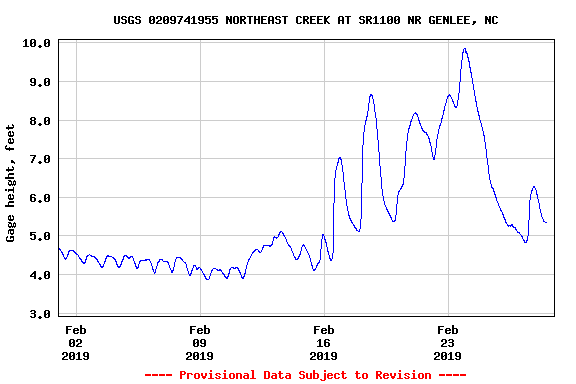
Notice the daily cycle for the first eleven days of February.  That is the record of the daily release of the TWWP, just that between roughly 5.0 inches and 4.5 inches.  Increased streamflow begins around February 12 and rises through multiple peaks to almost 10 feet before decreasing toward the end of the month, with one rainfall around February 28.

Compare this pattern with the pattern upstream from the stream gage at Carpenter-Fletcher Road.

A map of the wetlands at the junction of the main stream and Tributary D of Northeast Creek
Main Stream Junction with Tributary D

The yellow lines separate Tributary C on the east, Tributary D on the west, and a short minor tributary of the main stream in the middle.  The meanders and islands are the pattern that the main stream takes through this section in which it is receiving the flow from Tributary D, the long, more-or-less straight, stream on the left.

The diagonal line is a natural gas pipeline easement.

A map of the main stream junction of Northeast Creek with its tributary Kit's Creek
Main Stream Junction with Kit’s Creek

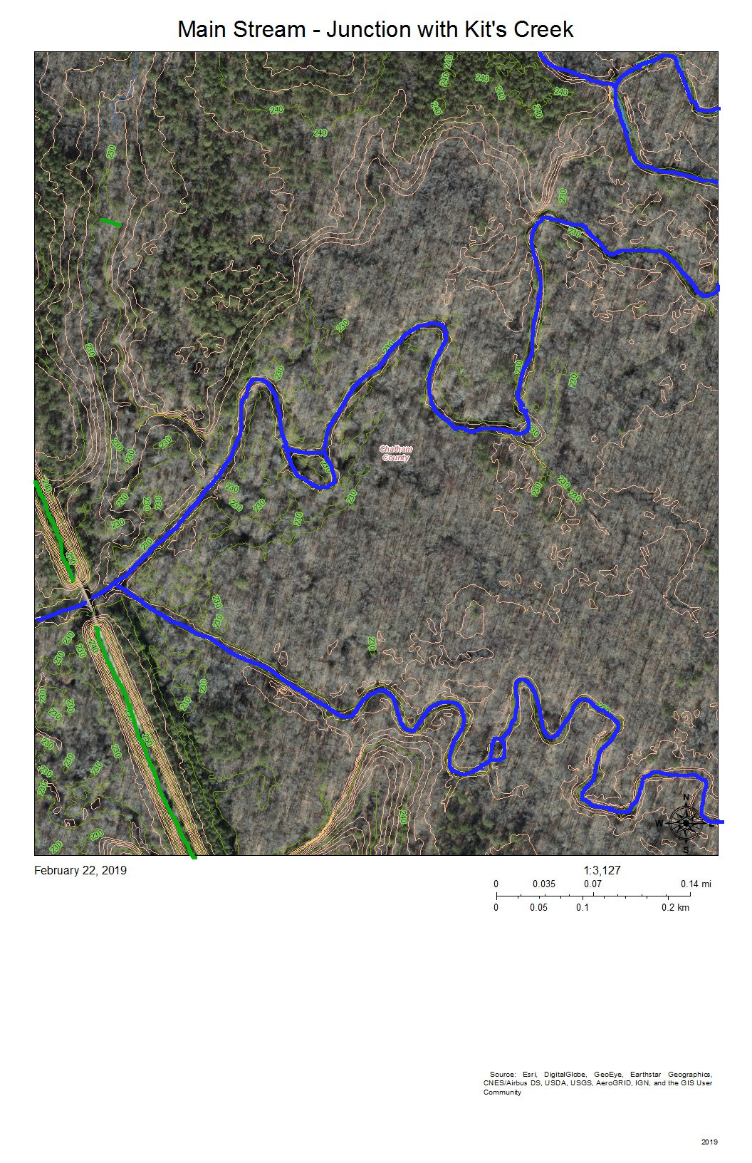
The green line at the bottom right is the Rails-to-Trails American Tobacco Trail (ATT) that runs from the Durham Bulls Athletic Park to the village of New Hill in Wake County.  The gap is just to allow the bridge over the Northeast Creek to be visible.

Kit’s Creek (Kitt’s Creek is also correct) flows from the southeast and joins the main stream of Northeast Creek right before the ATT bridge. This junction is in Chatham County.

The area to the north of Northeast Creek is bottom land hardwood forest that includes some magnificent beech trees and shagbark hickories.

This entire floodplain down to the rookery at the mouth by the NC 751 bridge is owned by the Corps of Engineers and administered by the NC Wildlife Commission as gameland.

Another fun activity is to see where your water goes when it leaves the Parkwood area.  A great way to explore this part of Northeast Creek is to hike or bike on the ATT; an alternative is to park at the parking lot by the NC 751 bridge, put in your kayak in the bay to the east and paddle upstream as far as you can (generally short of Panther Creek because of beaverdams and blowdowns).

Which Sub-basin of Northeast Creek Are You In? (For Parkwood Area Residents)

Creek Week is coming March 13 through 20. During that week Durham is focusing attention on how individual citizens and property owners can with modest efforts deliver significant benefits to the quality of water moving downstream, especially to Jordan Lake.

A fun activity during Creek Week is to find the path that water from your roof, sidewalk, driveway, and patio or deck takes as it goes to Northeast Creek, down Northeast Creek and into Jordan Lake, and down the Cape Fear River to Wilmington.

A map showing the main stem of Parkwood Creek, the watershed for Tributary C, and the watershed for Tributary D
Sub-basins of Northeast Creek in the Parkwood area

To do that, we must perceive streams and their tributary flows of runoff in the foreground and land in the background. Focusing on the flash flood zones at full flood (the flood zones identified on the Sub-basin map) shows the land as necks extending into the fully flooded lake headwaters. After all, one of the primary purposes of Lake Jordan was mitigation of the flash flooding that often occurred in the Haw River and New Hope Creek basins.

We see that Parkwood comprises parts of three sub-basins:

  • The main stream of Northeast Creek on the east;
  • Tributary C feeding Parkwood Lake in the center;
  • Tributary D draining the western part of the McCormick high land and streams from Hunters Woods joining and running down Wineberry to the west.

To find out which sub-basin you are in, find where your house is on the map.

For reference, look for these landmarks:

  • Parkwood Elementary School
  • Parkwood Fire Station
  • Gas House Shell Station
  • South Durham (SoDu) Farmers Market at Greenwood Commons.

Click on the image of the map. Use Ctrl-+ to enlarge the map. Now look for the landmarks.

Now trace the path the water takes from your house to the main stream, Tributary C, or Tributary D.

Are any streams by your property?

Which sub-basin do they flow into?

Where does the runoff from your house enter a stream?

Does it flow through a stormwater drain or stormwater pipe? Where does the water drain into a stream?

Does it flow down intermittent creeks that only have water when it rains?

A fun activity is to put on your rain gear when it rains and follow the water where it flows until you locate the storm drain and stream into which the runoff flows.

A tree full of stars

The largest tree beyond my door, and one of the largest trees in the immediate neighborhood, is a sweetgum. It probably isn’t that old and there are larger trees around, but it is still about 2′ in diameter and roughly 90 to 100′ tall, with furrowed light gray bark dappled with patches of a white crustose lichen on its trunk and pale green lichen on its branches (not as luxuriantly lichen covered as nearby oaks). Young sweetgums growing in a field have a conical, Christmas tree shape, and sweetgums actually have several ties to Christmas (this article was originally written for December). A sweetgum’s canopy usually becomes rounded with age, as is the case with this tree, and lower limbs growing into utility lines have been cut occasionally, so most of its great boughs are high in the air. It is a very exuberant tree. Many years ago it was surrounded by a grove of small sweetgums, at least some suckers from large exposed roots, and more still sprout. Some of the limbs of the big sweetgum develop vertical shoots that look just like large saplings several feet tall, later bending outward. Sweetgums probably aren’t meant to have a spreading form, and this tree has long had open space on most sides. Large sweetgums often have limbs that angle upward a short distance, with limbs closer to vertical branching off from the ends, and I might have seen how this form comes about. One calm summer evening a few years ago I was standing by a window when there was a whooshing sound and a huge, leafy limb fell, almost on our residential powerline. The top has been snapped off by lightning or wind at least once. Recently large pieces of a partially dead limb have fallen and there might be more dead branches than usual after the prolonged drought last summer and fall. At one time there was a very large squirrel nest made of leafy twigs in the principal fork high in the canopy, and hawk pairs have seemed to consider nesting in late winter. Birds often perch at the very top and during the winter some pry seeds out of the prickly ‘gumballs.’ Virginia creeper climbs up the wide trunk. Sweetgums might seem commonplace, but they have ecological and historical depths now largely forgotten.

Sweetgums are probably very familiar. In many places they are one of the first and most abundant woody pioneers to sprout in abandoned fields, joining other early successional trees like loblolly pines, cedars, winged elms, and ashes. Sweetgums bear large star-shaped leaves with five (sometimes seven or three) sharp, triangular points with slightly serrated edges, on very long petioles (leaf stems), and are often clustered on short side twigs. Along the west wall of UNC’s Coker Arboretum there is an unusual specimen whose leaves have five rounded points, an example of the Rotundiloba or roundleaf cultivar, apparently discovered in North Carolina in the 30’s and sterile. This tree is the state’s largest roundleaf sweetgum (90′ tall), according to the NC Forest Service, and there are others in the Arboretum. When bruised a sweetgum’s relatively thick leaves give off a characteristic, resinous fragrance reminiscent of pines. The leaves alternate along relatively thick twigs, green to bronze when young, spotted with pale lenticels, pores that allow the woody tissues to breathe, and sometimes corky growths. These warty growths can grow into “wings,” like those along the more delicate twigs of winged elms, which also grow in open areas and young woods, but sweetgums usually have smaller wings, if any, and have more robust twigs and buds than elms. Sweetgum twigs are supposed to have star-shaped pith in cross section, but I haven’t seen this so far. The furrowed but relatively soft pale gray bark, up to an inch or more thick, is one reason for the rare common name alligatorwood. The big sweetgum has light gray bark, very light gray on the south side (I wondered if the color was due to lichen, but it looks like bare bark), while a smaller sweetgum nearby has darker grayish bark.

The big, glossy greenish to bronze-colored terminal buds and smaller lateral buds, covered in a few large hair-fringed scales, glint in the wane winter sun, and it is a sign of spring when they begin to swell outside my window. It feels like no sooner do these big buds open, leaving pale yellowish bud scales littering the ground, then the spent male flowers also drop. Each monoecious tree produces flowers of both sexes, the yellowish green clusters of male flowers form spheres on stalks about 1 ½” tall, held upright at the twig tips as the shiny, vaguely spidery new leaves begin to unfold, while the female flower clusters hang as spiky green balls, much smaller than the mature fruit, each flower producing up to two seeds. The two styles of each flower become long spikes or beaks on the gumballs.

The dark brown mature ‘spiny’ gumballs can be seen dangling high in the air against the bracing skies of winter. They could be confused with the light brown balls of windborne seeds hanging on American sycamores, but sycamores have unmistakable pale bark, brown and flaking low on the trunk, becoming dappled green and then stark white at the treetops. In early winter I hear bits of pale grit falling on the leaf litter, and I think this come from the sweetgum, but their seeds are actually dark and resemble tiny miniature ash keys. Gumballs carpet the ground and a neighboring driveway by late winter, and help develop calluses when walked on bare foot the rest of the year, though they eventually wear down to merely rough balls.

In the fall sweetgums are valued for color, with leaves turning light yellow, red, and purple, sometimes nearly black.

As pioneers, sweetgums dislike shade and put on height quickly to keep their place in the sun. They can grow up to 150′ tall and 5′ across or more. The NC Forest Service lists two champion American sweetgums, a 134′ tall tree at Merchants Millpond State Park and a tree 138′ tall, but with the same circumference, in Wilson County. There are two national champion sweetgums, in Virginia and Texas. Two large sweetgums near the corner of Lawson and Lincoln streets at NCCU might be the largest I have seen by some inches, and pretty large sweetgums are common in the bottomlands along Northeast Creek. Reportedly a sweetgum can live for 400 years.

Sweetgum has been known as liquidamber, bilsted, red gum, star gum, and American storax. Its scientific name is Liquidambar styraciflua, coined by Linnaeus in 1753; the generic name meaning “liquid amber” while the specific name means “flowing with styrax (storax).” Earlier, in 1686, English naturalist John Ray had termed it Styrax liquida. Depending on the system, sweetgums are in their own family or are classified with witch hazels, uncommon woodland shrubs that bloom in winter on steep hillsides above Northeast Creek and elsewhere in the Triangle.

Sweetgums of some kind have been around for at least 99 million years and once grew across the Northern Hemisphere, but today there are only three other species: L. orientalis in Turkey and two species in East Asia, L. formosana and L. acalycina. American sweetgums range from southwest Connecticut through much of Eastern North America, south to Nicaragua. According to the Tropicos floral database, sweetgums are known as tzo-te in Chiapas and Guatemala, quiramba in Guatemala, and liquidambar in Belize, Honduras, and Nicaragua.

The Spanish recognized sweetgum by its fragrance when they first encountered it in the New World. The Old World’s storax or styrax, a fragrant resin, was used in incense, perfumes, medicines, added to wine, and applied to hair but the source was mysterious in Europe, beyond vendors in places like Constantinople. Linnaeus gave the name Styrax to a genus of small trees, some found here, thinking that one of them was the source, but today classical storax (or rosemalles) is thought to come from Turkish sweetgums, originally harvested by Turkey’s Yuruks, a nomadic Turkic group. This traditional industry is reportedly endangered. Apparently the Turkish sweetgum was scientifically described only in the mid-19th century. In his first hand account of the 16th century conquest of Mexico conquistador Bernal Díaz del Castillo describes the feasts presented to Aztec emperor Motecuhzoma Xocoyotzin. Included were “three tubes much painted and gilded, which held liquidambar [apparently called xochiocotzoquahuitl in native Nahuatl, referring to the pinelike fragrance] mixed with certain herbs which they call tobaco.” After eating the emperor would inhale a little smoke and sleep, a reported effect of storax. The Spanish might have first encountered American storax used in incense a few years earlier further down the coast of Central America. Several years after the war in Mexico, Álvar Núñez Cabeza de Vaca encountered sweetgums growing near Appalachicola in Florida during the Narváez expedition.

American storax, also called copalm balm, was described as a heal all by 16th century Spanish herbalist Francisco Hernández de Toledo, who spent several years researching in Mexico and Central America. John Banister is credited with introducing sweetgums to Europe in 1681. In 1839 styrene was first distilled from storax, and about a century later styrofoam was made from polystyrene. Storax was used to treat illnesses such as dysentery during the Civil War. An American storax industry developed during WWI, but was subsequently abandoned in favor of cheaper storax from abroad, only to be reactivated around WWII when the supply from the Japanese-held Taiwan was cut off. Apparently the expertise was only retained in Clarke County in southwest Alabama, making it the center of the wartime industry. A sweetgum there produces only ½ to one pound per year, and the amount is supposed to depend on the amount of foliage and increases going south.

In recent times storax has been used in salves, adhesives, fragrance, perfuming powders, perfume fixative, soap, and tobacco flavoring. It has been smoked for sleep, chewed for sore throat, colds, diarrhea, ringworm, catarrah, and applied to sores, wounds, piles, etc. It was used to clear mucous, and as an anti-septic and anti-inflammatory. Sweetgum leaf essential oil is chemically similar to Australian tea tree oil. The inner bark was boiled with milk to alleviate diarrhea. The resin has long been a chewing gum and teeth cleaner. Storax (not necessarily American) is supposed to be a component of commercially available compound tincture of benzoin.

Sweetgumballs are or were painted and hung on Christmas trees. They could probably also be used in crafting and if nothing else cats chase them. Chinese sweetgum balls, apparently called lu lu tong in Mandarin and softer than our gumballs, are used herbally.

Sweetgums are a prominent source of lumber, with heavy and strong but not very flexible wood. After about 60 years trees develop reddish heartwood below the white sapwood. Sometimes the sapwood was sold as sap gum and the heartwood as red gum. Unesteemed “gum wood” was often called satin walnut or hazelwood and could even be passed off as exotic Circassian walnut, rosewood, and mahogany. The wood polishes and stains well and the heartwood can display interesting figures. Sweetgum has been used in furniture, indoor trim, veneer, flooring, crates, cigar boxes, toys. barrels, boats, chopsticks, woodenware, plywood, railroad ties, and for pulp.

Many bird species, squirrels, and chipmunks feed on sweetgum seeds, while beavers eat the bark. Larvae of a sweetgum bark beetle bore in living and dead wood. Many moths eat the leaves as caterpillars, including several common geometers (inchworms), luna moths, promothea or spicebush silkmoths, hickory horned devils (the impressive caterpillars of regal walnut moths), imperial moths, sweetgum leafrollers, and the large Paectes. The big, ethereal light green to yellowish, long tailed luna moth, once known as the pale empress of the night, is relatively common and its caterpillars can feed on several tree species, but their abundance seems to vary greatly across the Triangle. They seem to be abundant around Falls Lake; a few years ago I would often notice the large black barrellike droppings of caterpillars under sweetgums and look up to see the thick green accordion-shaped caterpillars with yellow markings hidden high overhead. Luna moths might also be common around NCSU. On the other hand I’ve seen few around Jordan Lake or in Chapel Hill and Durham, though sweetgums are common there too (but tuliptrees might be the more common deciduous pioneer in Chapel Hill).

The not-so-familiar black walnut

Black walnuts are familiar yet very unusual and valuable trees, and quite rare growing wild around here. At Jordan Lake State Recreation Area’s Seaforth access there are several exceptionally large trees of various kinds, including a black walnut. It’s spreading boughs are shaggy with resurrection ferns, verdant green after rain, contrasting with the yellowish-green of the walnut leaves, and appear dead at other times. The walnut is partially hollow and has dead branches, so it seems precarious and I wonder if the raised water table and/or heavy summer foot traffic is harming it. There are several much younger walnuts nearby. Near UNC’s Friday Center there is a black walnut about 2′ across, with a plaque saying it sprouted circa 1880. Large walnuts line paths at Durham’s West Point on the Eno. There are a few walnuts in the Northeast Creek basin. A tall tree more than a foot across grows at the base of a moist northwest facing slope near tributary Burdens Creek. It is a mystery how it got there. A few miles away there are spindly but nut-producing walnuts growing wild by a road in Chatham County connected only to Durham and Wake.

Their large nuts, classified botanically as drupes, fall around October, later than acorns and hickory nuts. An unusual feature is their smooth, relatively soft, fragrant, yellowish-green changing to black, staining husks, resembling a lemon more than a nut such as a pecan. Last fall there were unusually few walnuts under the Burdens Creek tree, whether because of the drought or because production varies yearly. On the other hand smallish nuts covered the ground under the Chapel Hill tree last October, and squirrels were gathered when I visited.

Black walnuts have dark, regularly furrowed bark and are tall and narrow in forests but short and very broad without competition. Giants can grow to 150′ tall and 6′ across, but walnut wood is valuable, so valuable that trickery and poaching occurs, and many were cut. They have large pinnately compound leaves up to 2′ long and 6” wide, with 9 to 23 long-pointed and serrated leaflets in pairs, smaller at the ends of the leaf, and usually there isn’t a leaflet at the tip. The leaflets have very short stems (petiolules) and the compound leaves alternate along the twigs. There is some hairiness on the underside of the leaflets and the leaf stem, called a rachis. Broken leaves and husks have a distinctive smell, lemony to me. Their leaves turn yellow early, contrasting with the dark trunks.

Several trees have similar leaves. White walnuts or butternuts, native in the Smokies, and introduced here, have oblong nuts, fewer leaflets (but usually with a terminal leaflet), and while both walnuts have chambered pith inside their twigs, it is darker brown in butternuts. Both species have grayish buds and the leaves fall to reveal three-lobed leaf scars, but there is a hairy spot only in butternuts and their buds are elongated. Hickories, such as bitternuts and pecans, are in the walnut family, but typically have fewer leaflets per leaf, a terminal leaflet, buds covered in scales, pith without chambers, and their nuts are usually dehiscent, opening along sutures. Locusts and Ailanthus also have pinnate compound leaves but are often small trees with multiple trunks growing in open areas. Ailanthus have very large leaves and leaf scars, a distinctive smell, and are most common in built-up areas while black locusts are thorny and produce fragrant white pealike flowers in late April.

Black walnuts seem to like well-drained soil and usually grow far from waterways. They grow fast, but are long-lived and don’t like shade, and they have a way to preserve their sunlight.

Black walnuts produce wind-pollinated catkins before leafing, each tree having both sexes. The dangling male catkins are 3 – 5” long. The female flowers are in clusters of 2-5 near the twig tips. The male and female flowers open at different times, but self-pollination is possible. A sapling can produce nuts after only five years, but few until age 10 – 15. The huge nuts are covered in a smooth husk, surrounding a seed with very thick, irregular wooden walls. ‘Everyone’ eats the nuts, yet I often find many left under wild trees and it takes a lot of effort to get inside. Apparently walnuts need a long cold period to sprout, and squirrels can steal planted nuts.

Black walnuts are known botanically as Juglans nigra, the generic name being an abbreviation for Latin Jovis glans, the acorn or nut of Jupiter (it was said people once lived on acorns while the gods ate walnuts). The word walnut originally referred to Persian walnuts, and is supposed to be a combination of the Anglo-Saxon for Welsh or Celtic, signifying foreign, and nut, wealh hnutu, as opposed to hazelnuts. Walnuts are honored in many place names, such as Cary’s Walnut Creek.

An unusual feature of black walnuts is their allelopathy. The walnut near Burdens Creek grows in a mature deciduous forest, but is in a sunnier glade. Around now toothworts and other early wildflowers bloom around it, joined by pink redbuds, an understory tree in the pea family, and in summer other peas cover the ground. Legumes often carpet the ground under walnuts in summer. Black walnuts produce hydrojuglone, which oxidizes into juglone and washes into the soil, to poison competitors, though ash, legumes, etc. seem immune. Some soil bacteria seem to be able to live on juglone.

Despite poisoning other plants, walnuts are edible to many animals. Squirrels, white footed-mice, and chipmunks disperse the nuts. In winter rabbits and deer nibble saplings. On the other hand walnut is harmful to horses and fish. Many insects feed on walnuts, including a curculio weevil, woodboring beetles, the walnut lace bug, stinkbugs, and aphids. Walnut fruitflies are supposed to develop in the husks, but I haven’t seen any. Many lepidopterans consume walnut, including one small butterfly, the banded hairstreak. Moths include gigantic hickory horned devils (caterpillars of the royal or regal walnut moth), related imperial moths, luna moths, walnut caterpillars and other Datanas, monkey slugs, walnut sphinx moths, curved-tooth geometers (a relatively large dark brown moth common at lights around April or May), American dagger moths and relatives, salt marsh caterpillars, fall webworms, walnut shoot moths, and several more.

Walnuts have a lot of versatility for humanity. Nuts are gathered from the ground and the nutmeat can be eaten raw, ground into flour, or boiled for oil used for cooking, fuel, and as polish (butternuts are more famous for oil). The trees can be taped like sugar maples. The husks produce a dye used to color cloth and even hair, and as ink. Walnut is supposed to repeal bedbugs and other insects, and I have wondered if the husks could be used to treat wood. Pulverized nuts are used in abrasives, filters, tires, composted, etc. The beautiful smooth wood was also used in furniture, paneling, veneer, cabinets, carriages, sewing machines, appliances, musical instruments, and for both cradles and caskets. During wars it went for gunstocks and airplane propellers. Walnut resists decay, so it was used for rail fences and railroad ties.

The leaves and husks have been known to cause dermatitis, but there are many herbal uses. The bark was used for toothaches; husks were used for ringworm, external inflammation, and to cause sleep; leaves were used for insect repellant and reportedly for sunscreen; and various parts were used to treat gastrointestinal problems. Juglone could be useful as a sedative and cancer inhibitor.

Thousand canker disease is an emerging threat for walnuts, though still far from here. Unlike other new catastrophic forest maladies like emerald ash borer and laurel wilt, thousand canker disease is native to North America, but was apparently unknown in the East until it reached Knoxville around 2010, so black walnuts still lack resistance. Thousand canker disease is caused by a recently discovered fungus spread by the walnut twig beetle, native in the Southwest and Mexico. In fall 2012 the disease was found in Haywood County, bordering Tennessee, but it is not known to have spread elsewhere in North Carolina since. The disease is present in several Western states, but only four Eastern states. Butternuts are susceptible and also face a canker noticed in 1967, probably from Asia. So walnut is another wood to be careful about moving over distances.

City Plans Northeast Creek Improvements

The City of Durham’s WATERways for November announces:

“The City of Durham has a new plan to help reduce sources of bacteria in Northeast Creek. Fecal coliform bacteria can come from the waste of humans, livestock, urban and rural wildlife, waterfowl and other birds, and pets. Reduction strategies include improving septic system performance, reducing sanitary sewer overflows, promoting pet waste pickup, and preventing Canada Geese waste near lakes and ponds. “

The full plan is Total Maximum Daily Load Response Plan for Fecal Coliform Bacteria in Northeast Creek(Cape Fear River Basin), Durham, North Carolina , ( February 22, 2019).

An online version of the WATERways newsletter is here.

Summer Reading Enjoyment

Here are some books for your summer reading enjoyment.  We start with snippets of three Rob Dunn books .  According to his most recent biography,  Rob Dunn is a professor in the department of applied ecology at North Carolina State University and in the Natural History Museum of Denmark at the University of Copenhagen.

This reading list includes all five of his books.  He lives in Raleigh, North Carolina.

Every Living Thing: Man’s Obsessive Quest to Catalog Life, from Nanobacteria to New Monkeys, Smithsonian Books, 2009

The wild leaps up and more often than not we do not even know its name.

I began to see similarities not only among the scientists who made big discoveries, but also in how Western scientists and society responded to those discoveries.  For one, we are, before these discoveries, always more ignorant than we imagine ourselves to be. […] we are repeatedly willing to imagine that we have found most of what is left to discover.  Before microbes were discovered, scientists were confident that insects were the smallest organisms. Before life was discovered at the bottom of the ocean, many scientists were confident nothing lived deeper than three hundred fathoms.  Once we made a tree of life that included four kingdoms (animals, plants, fungi, prokaryotes), we were confident that there would be no more major branches to reveal.

…most species on Earth are not yet named. Most named species have not yet been studied. When we lived in small communities, hunting and gathering, we knew only the animals and plants around us, particularly those that were useful or dangerous.  Living on the thin green surface of our small planet in a universe full of stars, we are not so different today.  The wild leaps up and more often than not we do not even know its name.

The Wild Life of Our Bodies: Predators, Parasites, and Partners That Shape Who We Are Today, Harper Collins, 2011

Let our lives again be where the wild things are.

In the pages that follow, I tell a story of the consequences of our changing relationship with the rest of nature. I begin with our parasites and then discuss, in turn, the species we depend directly on (our mutualists), our predators, and then our diseases.  I conclude by considering the crossroads at which we find ourselves.  We have options. One,  the one we are headed towards, is a world removed from nature (which is itself increasingly impoverished) and we are sicker, less happy, and more anxiety-ridden for it. In this world, we treat our problems with more and more medicines in an attempt to use chemicals to restore what we miss from other species. We live in a bubble from which we look out at the rest of life.  The other options are more radical but no less possible.  Through the stories of a handful of half-wild visionaries, I will consider some of these radical options that include giant living buildings, predators in our cities, and the restoration of parasitic worms to our guts’ wild plants.

In the end, what we need in our daily lives is not quite wilderness.  Wilderness is what did away away with to allow ourselves to live free of malaria, dengue, cholera, and large carnivores eating our loved ones. It is taboo to say that we should manage the nature closest to us for us, but ever since we started to farm or control pests that is what we have always done.  The step we must take now is to manage with more care and nuance.  We can favor good bacteria in our mouths and discourage bad bacteria.  We can introduce harmless nematodes into our bodies to restore our immune system.  We can expose ourselves to species in which we find joy, curiosity, and happiness.  We can even, more creatively, create green cities, cities more revolutionary than just buildings with green rooftops, cities in which entire walls are built out of life. Imagine butterflies emerging from cocoons growing on flowers growing out of high-rise apartment balconies.  Imagine predators diving on prey on street corners — hawks in Manhattan, bears in Fairbanks. Imagine all of them, more of them — and their wild calls, back outside our doors.

Never Home Alone: From Microbes to Millipedes, Camel Crickets and Honeybees, the Natural History of Where You Live,  Basic Books, 2018

When it comes to the species mating, eating, and thriving alongside us, nothing is quite what it seems.

You might in hearing about all this life be inspired to go home and scrub, and then scrub some more.  But here is the other surprise. As my colleagues and I have looked at the life in homes, we have discovered that many of the species in the most diverse homes, the homes fullest of life, are beneficial to us, necessary even.  Some of these species help our immune systems to function.  Others help to control and compete with pathogens and pests. Many are potential sources of new enzymes or drugs. A few can help ferment new kinds of beer and breads.  And thousands carry out ecological processes of value to humanity such as keeping our tap water free of pathogens.  Most of the life in our homes is either benign or good.

Unfortunately just as scientists have begun to discover the goodness, the necessity even, of many of the species in our homes, society at large has stepped up efforts to sterilize our indoors…[W]e not only favor the persistence of these resistant species –we speed their evolution.

Not to mention, the area affected by these changes is immense: the indoors is one of the fastest growing biomes on our planet and it’s now bigger than some outdoor biomes….[T]he floor area indoors in Manhattan is now threefold greater than the dirt area outdoors.

The best we can hope for is to populate the indoors with species that benefit us rather than do us harm. But if we are to do so, we first have to understand the species that have already made it indoors, those two hundred thousand species that we know so little about.

Other books by Rob Dunn:

  • Never Out of Season: How Having the Food We Want When We Want It Threatens Our Food Supply and Our Future.
  • The Man Who Touched His Own Heart: True Tales of Science, Surgery, and Mystery.

Explore the life on Northeast Creek in the James Pullman Photos and the David Carter Photos under EXPLORE.

What a Thirteen Years It Has Been

In February 2006, I and ten others gathered at the Grandale Road bridge over Northeast Creek to do stream monitoring and go on a hike to see spring ephemerals. Michael Pollock had a water sampling kit from City of Durham Stormwater Services, and after we tested samples from the west side of the bridge, led us on a hike.

Walking along the Corps of Engineers boundary trail on the south side of Northeast Creek, we saw trout lilies and foamflowers that had just begun blooming. Walking up the natural gas easement back to Grandale Road, we could look northwest across the creek valley to where the gas easement crossed Scott King Road.

In April we tested Northeast Creek at an accessible meander just north of Sedwick Road. And then we went for a hike to see the budding trees and the spring flowers. The red maples glowed pink; the oaks were light green; some of the trees had a bluish cast. Stepping along the soggy ground of the sewer easement was challenging, but the world of the Parkwood wetland that we were walking alongside offered more natural beauty to explore.

In May, we tested again at the Grandale Road bridge. This hike explored the east side of Grandale Road and up the powerline maintenance access road. Toward the top of that hill, we crossed over to the Northeast Creek stream channel, which we viewed from rock bluffs on the south edge of Parkwood.

I was hooked. Northeast Creek Streamwatch was the organization that understood what my wife and myself had seen in 1993 behind the Food Lion store on NC 55. We had seen a wetland with submerged trees and saplings. A great blue heron was perched on one of the saplings; a green heron perched on a slightly larger sapling nearby. That swamp has now become an open pond in flood times, most of the trees drowned. Beavers and property owners have re-engineered the water flow many times over the last 25 years. And I have become committed to preserving our Triassic Basin wetlands, their flora, and fauna for my grandchildren’s grandchildren’s grandchildren to be able to appreciate.

In the 13 years since then, the “we” that is the evolving association of people identifying with Northeast Creek Streamwatch have seen:
• Regular participation in the Parkwood Christmas Parade by puppets of a great blue heron, beavers, an opossum, and frogs.
• Spring and fall clean-ups of creeks that result in piles of dumped items for Durham Solid Waste to pick up the next week after Earth Day, Big Sweep or Creek Week.
• A class at Parkwood Elementary School about sand, clay, and silt and third graders planting and labeling native plants for a WaterWise garden.
• Library programs on the native plants of Northeast Creek and the techniques of rainwater harvesting.
• A kayak touring company that did trips up from the mouth of Northeast Creek at the NC 751 bridge almost to Panther Creek in Chatham County.
• Hikes along a Jurassic diabase dike formation to the ruins of Sears Mill, an old mill on Panther Creek.
• Testing at Northeast Creek crossing of Grandale Road, Sedwick Road, Ellis Road, and in Meridian Center.
• An umbrella magnolia by Northeast Creek at Ellis Road bridge.
• The descent of a source of Northeast Creek down a steep slope by the Durham Freeway as the creek crosses under the bridge on Glover Road, passes through a steep gully and crosses under the Durham Freeway.
• The seep behind an office near NC55 and Riddle Road that is one of the sources of the prong of Northeast Creek that flows just west of NC 55 down to Meridian Park.
• The runoff from US70 north of Miami Boulevard that flows through the parking lot of pawn shop and into woods into the back yards of folks on Peyton Avenue, yet another source of Northeast Creek; this tributary flows through Bethesda Park..
• A dump site adjacent to the creek of over 50 years duration that is grown up with red cedars, winged elm, and oodles of vines.
• Sandstone caves beneath a bluff supporting leatherwood.
• The wetlands at Ellis and So-Hi roads that extend through the RTP properties of major companies and warehouse complexes.
• The main stream of Northeast Creek in flood at the NC 54, Sedwick, and Grandale bridges.
• A crew from Hillside New Technology cleaning the litter from the blackberry growth next to the NC 54 bridge over Northeast Creek during Big Sweep.
• A mother who brought her son from their neighborhood in North Durham to participate in a clean-up of the creek that feeds Parkwood Lake because she wanted to teach him a service ethic.
• The awarding of Durham’s Distinguished Tree designation to a white ash in Parkwood and a scarlet oak on the Lowes Grove Middle School property near the creek.
• The effects of the 2007 drought at the mouth of Northeast Creek, the appearance of a prairie of grass mat strewn with large mussel shells.
• Snow and ice in the Parkwood wetlands in a picturesque meander that Durham Water and Sewer later repaired with a culvert..
• Neighbors and their acquaintances reporting sewer leaks and stormwater issues to us and we getting to see that they are indeed efficiently handled.
• The Creek Critters Puppets marching as the Krewe de Creek in the Durham Mardi Gras Parade and promoting the 2016 Durham Creek Week.
• The Monarch Caterpillar art project from Fayetteville Street Elementary School at the Monarch Festival along with the students that made it and their parents.
• The recognition as Durham Soil and Water Conservation District’s Urban Conservationist of the Year in 2016.
• The support of some 40 volunteers in the construction of Parkwood Village Association’s Wiggly Trail , erosion control, and native plant garden. Completing this project with volunteer labor and donations in-kind to match a $2500 City of Durham neighborhood improvement project grant.
• Continued collaboration with Parkwood Village Assocation, Parkwood Homeowners Association, Christus Victor Lutheran Church, Lowes Grove Middle School, Parkwood Elementary School, South Durham Regional Library, South Durham Farmers Market, and local scouts as well as many longstanding individual partners.

In the coming year the wildness will continue as we seek to grow participation in these initiatives:

Upstream Neighbors/Downstream Neighbors – The grassroots network of property owners and residents working on their own to conserve their own part of the Northeast Creek basin. Opportunities and tools to serve them are rainwater retention ideas, planting native plants, removing invasive plants, local creek clean-ups, adopting storm drains, adopting stream segments, adopting highways for cleaning litter. Citizen science activities include Audubon’s Backyard Bird Count, iNature.org, and many others. For additional citizen science opportunities, contact the NC Botanical Garden and the NC Museum of Natural Science.

Upstream Neighbors/Downstream Neighbors serves as a network to involve local schools and churches at the local level in local projects, which over the 47 square miles of the Northeast Creek basin means that seemingly small local efforts can result in large results on Lake Jordan’s quality just as small amounts of negligence have added up to a large excess nutrient problem for Lake Jordan.

Water Stewardship Network – The supporting network of schools, churches, government agencies, businesses, and voluntary associations that have an impact on Northeast Creek and ally with similar groups in other watersheds. These institutions support individual efforts as part of Upstream Neighbors/Downstream Neighbors. These are the locations of events, demonstration projects like gardens or rainwater treatments, and educational programs. They are Upstream Neighbors/Downstream Neighbors for their own property. Northeast Creek Streamwatch’s water stewardship network can tie into the North Carolina Watershed Stewardship Network (http://wsnet.renci.org/huc_report/index.html?huc=030300020605).

Creek Week and Big Sweep Events – The twice a year momentum builder for local efforts. They get people out into the stream environment and wetlands, show the natural beauty, and get something tangible accomplished with a very short commitment of time. This year’s Creek Week is March 17-23, 2019. Start planning local events for March 15 -23 and notifying colleen@northeastcreek.org.

Get Ready for Spring

Save the date:
Clean Water for the Triangle – How to Take Action, Monday, March 19, 2018, 6:00 PM 8:00 PM, Lowes Grove Middle School (map.) A talk with the Haw Riverkeeper and local advocates about threats to local watersheds and ways to defend safe drinking water for all. Register

Here are the tips to get spring off to the best of the Northeast Creek watersheed.

  1. Watch the arrival and departure of spring ephemerals. 11 Spring Ephemerals Native to Lake Lure and Hickory Nut Gorge Lake Lure is in the mountains of Rutherford County, NC, between Rutherfordton and Asheville. How many of these same spring ephemeral flowers show up in the wetlands and uplands of the Northeast Creek basin some 220 miles along I-40? Check out the James Pullman Photos and the David Carter Photos on this site to get some clues to where they typically appear.
  2. Watch and listen as the spring migrating birds replace the winter migrants. The Cornell Lab of Ornithology
  3. Identify trees and shrubs by the ready condition of their axial buds. Winter twig keys to common, native, fully deciduous trees and phanerophyte shrubs of the North Carolina eastern piedmont Part of the NCSU Herbarium
  4. Listen for frog sounds in the morning and evening as the day warms and cools. Toads and frogs observed the the Northeast Creek basin include:Bufo americanus (American Toad); Hyla chrysoscelis (Cope’s Gray Treefrog); Pseudacris triseriata (Western Chorus Frog); Pseudacris crucifer (Spring Peeper); Gastrophryne carolinensis (Eastern Narrow-Mouthed Frog)
  5. Notice which insects awaken and are early to appear. NCSU Extension: Entomology
  6. Get your own yard ready for spring. Spring garden clean up done RIGHT
  7. Identify the erosion and drainage issues to address in your yard this year. Durham Soil and Water District: Community Conservation Assistance Program A key partner in Northeast Creek Streamwatch’s Upsteam Neighbors/Downstream Neighbors watershed improvement program using individual porperty-owner initiatives.
  8. Look for ways to save first inch of rainfall on your property during each rainstorm. Another piece of the Upstream Neighbors/Downstream Neighbors program for which Durham Soil and Water District can provide free consultation to homeowners. Durham Soil and Water District: Community Conservation Assistance Program
  9. Gather your neighbors to walk and clean your roadway of litter.
  10. Inspect the intermittent streams paths and creeks for litter to clean up during Creek Week, for excessive erosion, and for invasive plants. Invasive Plants found in the Piedmont of North Carolina
  11. Help Northeast Creek Streamwatch celebrate Creek Week 2018 Durham Creek Week, March 17-24— Events
  12. Come and talk to us at the Northeast Creek Streamwatch tent at the South Durham (SoDu) Farmers Market Saturdays 9am-12noon at Greenwood Commons (NC 55 and Sedwick)
  13. Attend Clean Water for the Triangle – How to Take Action, Monday, March 19, 2018, 6:00 PM 8:00 PM, Lowes Grove Middle School (map.) A talk with the Haw Riverkeeper and local advocates about threats to local watersheds and ways to defend safe drinking water for all. Register

For more information contact colleen@northeastcreek.org.

Book Review: A New Way of Landscaping that Creates Habitat for Our Wildlife

Thomas Rainer and Claudia West, Planting in a Post-Wild World: Designing Plant Communities for Resilient Landscapes, Portland, Oregon, Timber Press, 2015, 271pp.

Douglas W. Tallamy, Bringing Nature Home: How You Can Sustain Wildlife with Native Plants, Portland, Oregon, 2007, Timber Press, 358pp.

Andrea Wulf, The Brother Gardeners: Botany, Empire, and the Birth of and Obsession, New York, Knopf, 2008, 359pp.

Rainer and West in Planting in a Post-Wild World write:

…[A] new way of thinking is emerging. It does not seek nature in the remote mountain tops but finds it instead in the midst of our cities and suburbs. It looks at our degraded built landscapes with unjaded eyes, seeing the archipelago of leftover land—suburban yards, utility easements, parking lots, road right-of-ways, and municipal drainage channels—not as useless remnants but as territories of vast potential. We pass them every day; their ordinariness is what makes them special. As such, they are embedded in the fabric of our lives, shaping our most recurring image of nature.

The traditional landscaping that we inherited from the early gentlemen and merchants and their gardens evolved into landscape culture of “naturalness” as the picturesque preference for long views, open landscapes, clean edges, and touches of mystery. As a result, the general public has little tolerance for wild, illegible landscapes and plantings, especially in cities and towns. When people encounter highly mixed plantings, they are often reminded of abandoned fields or derelict industrial sites, places often associated with urban decay or neglect.

Rainer and West give us an alternative vision that can begin with our yards and be adapted to our communities.

So what exactly is the planting of the future? Look no further than just outside your front door. Go find a patch of weeds in your neighborhood. Notice the variety of species and how they interweave to form a dense carpet. Or better yet, take a hike in a nearby natural area. Look closely at how plants grow in a meadow or a forest’s edge. Observe the lack of bare soil and the variety of ways plants adapt to their site. Then when you get back to your neighborhood, compare those wild communities to the plantings in landscape or garden beds. There is a difference between the way they grow in the wild and the way they grow in our gardens. Understanding this difference is the key to transforming your planting.

…the solution lies in understanding plantings as communities of species that cover the ground in interlocking layers.

Notice that the question for gardeners shifts from what to plant to how to plant.

By focusing on naturally occurring plant communities, as opposed to those that are purely native, the focus is shifted from a plant’s country of origin to its performance and adaptibility.

All it takes to become a plant community is:

1. All plants should survive in similar environmental conditions.

2. Plants must be compatible in terms of their competitive strategies, the key to having plants that last.

The practice is to cover the ground densely by vertically layering plants. As the light levels drop under a tree, grasses transition to a mass of ferns, maintaining a continuous sea of plants. The bases of trees where traditional planting often piles mounds of mulch can be filled with plants (green mulch) instead. Any space around the base of a plant is a space waiting to be filled. Even low plants benefit from being under-planted with creeping plants.

Rainer and West talk about ” naturally occurring plant communities, as opposed to those that are purely native.” Doug Tallamy in Bringing Nature Home is an entomologist concerned about the insects that consume native plants and support native insectivores, like birds and amphibians. Tallamy goes to the ability of the native insects to survive on the plant, regardless of its origin but notes that even alien plants with similar origins accommodate fewer insect species than native plants. The ability of insects to survive to eat and pollinate the next year’s crops of native plants is critical to the survival of those native plants. As habitat is destroyed in development, as pesticides and herbicides are broadly applied without planning, the links between native plants, native insects, and native birds are broken and we start to notice population declines of birds and popular insects, like butterflies and showier moths. Tallamy describes these relationships in his chapter, “What does bird food look like?”

Whatever else it is, local habitat extinction is a local ecological and horticultural crisis. Having the native plants for native insects is the security for the habitat of the rest of the food web. And whatever impact native insects have on alien plants, alien insects frequently have had devastating impacts on native plants. And alien insects are frequently transported on alien plants.

How did we get so enamored of ornamental exotic species in the first place? Andrea Wulf tells the tale of how, on the British side of the Atlantic, wealthy gentlemen and merchants with networks of correspondents around the world traded plants from one continent to another. Andrea Wulf’s The Brother Gardeners describes how that correspondence and shipment of boxes of plants produced the explorer-botanists who would search out and ship the boxes of these new exotics as they were laying the foundations of the science of botany in the midst of Britain’s expansion of its empire. She then traces that history to the English obsession with gardening that was exported to America.

Peter Collinson had a correspondent in Pennsylvania named John Bartram, who regularly shipped him boxes of native plants from the eastern coast of America. Another correspondent, a Father d’Incarville sent seeds of Ailanthus altissima from China to Collinson in England in 1751; within a few decades, the tree of heaven had arrived in America. Because it is resistant to pollution, it was widely planted. Today it is considered an invasive species. In 1739 the Camellia japonica camellia had arrived in England and was on its way to America. It is one of the mainstays of ornamental exotics and quite well behaved; its popularity increased the replacement of native plants (such as rosemallow) with ever more camellias. In fact, the default landscaping for local gardens tends to be these exotics that are the result of 300 years of globalization.

Wulf’s book introduces some of the early scientific botanists, such as Mark Catesby, whose Natural History of Carolina, Florida, and the Bahama Islands, (London, 1731-48) contains some of the earliest paintings of native plants and animals in the Carolinas. She follows the obsession with gardens that spread from France to England to America; a subsequent work of Wulf’s describes the gardening obsessions of the four first US Presidents, to whom much of our current styles of landscaping owe inspiration.

Save the Date: Durham Creek Week, March 17-25, 2017

picture of the 2006 clean-up crew at Grandale Drive bridge
Clean-up – Grandale Drive Bridge – 2006

It is time to save the dates again for Durham Creek Week. During Creek Week, Northeast Creek Streamwatch is encouraging volunteers to come out in neighborhood groups just to discover their local stream, explore it, clean it of litter or bulkier items. Northeast Creek also encourages volunteers to explore the wetlands that form the boundaries between many of our neighborhoods.

To participate in official Northeast Creek Streamwatch events, contact Colleen Haithcock (colleen@northeastcreek.org) to register. Also visit us at the South Durham Farmers Market during March.

To see announcements of events as they are scheduled, “like” Northeast Creek Streamwatch on Facebook.

Northeast Creek Streamwatch has been cleaning up locations on the creek since 2006; we have been participating in the Durham Creek Week clean-ups since 2009. Creek Week is a time to discover and clean up our local streams. It has been celebrated in Durham since 2009, with 1,937 volunteers collecting 117,270 pounds of litter to date.

Durham Creek Week 2017 will have events from March 17 through March 25. Save the dates now for the events that interest you and your family from the list of Durham-wide events..

map of northeast creek stream system
Northeast Creek System

The Northeast Creek watershed drains the southeastern part of Durham County, the northeastern part of Chatham County and the western part of Wake County. Water from Northeast Creek flows into Lake Jordan at the NC 751 bridge and from there down the Haw River to the Cape Fear River and out to the Atlantic Ocean at Cape Fear, south of Wilmington. If you live south of Glover Road or Riddle Road in Durham and between Fayetteville Road and Miami Boulevard in Durham County, or east of NC 751 and north of New Hope Church Road in Chatham County, or north of Green Hope Road and west of NC 55 in Wake County, you likely live in the Northeast Creek basin.

So find your location in your watershed, gather up some friend, family, neighbors, and co-workers, and schedule a creek clean-up for Durham Creek Week. It’s a great way to welcome spring!

Volunteers Preserving the Natural and Cultural Heritage of Northeast Creek