Conservancy functions preserve the quality and integrity of the natural and cultural environment of the Northeast Creek basin through research, conservation, preservation, and restoration.
In late July or early August last year I walked under a hackberry sapling in my backyard and thought, surely I won’t look up and see an arboreal rough green snake. Instead I was surprised to find a large green and brown mantis, and it was there almost every day through mid-September. The hackberry attracted a species of large, blueish-gray plant-sucking true bug, and the mantis ate those, and then cicadas, putting on weight. It stalked large dragonflies that perched on dead twigs but I never saw it catch one (it also stalked small katydids, but I’m not sure if it caught any). At night it rested, often upside down, its ‘beady’ green eyes turning black. Earlier that summer I saw a beautiful green nymph that might have been the same mantis. The adult was probably a female Chinese mantis (Tenodera sinensis), but it could have been a narrow-winged or Japanese mantis (Tenodera augustipennis), or a praying or European mantis, which is actually only one kind (Mantis religiosa). Later I found an eggcase, resembling that of a Chinese mantis, on a low plant nearby and nymphs are around again this year. There were also Carolina mantises (Stagomantis carolina), a small, mottled gray species with bright orange markings. One spent a night just before Halloween on a red maple snag covered with morning glories vines. There are more than 2500 species, and over 11 in the USA (and introduced species might be harming native mantises). Mantises or mantids were classified with grasshoppers as orthopterans and then given their own order, Mantodea. Mantises are closest to cockroaches and termites, and they can all be grouped together as dicytopterans.
Also in the area there are much smaller but also predaceous mantisflies, which resemble a cross between a mantis and a wasp or fly, but they are neuropterans like lacewings and antlions.
Mantis comes from Greek for prophet, and mantises are charismatic creatures worldwide. Here they have been called soothsayers, rearhorses, devil-horses (god-horse in the Caribbean), praying locusts, and mulekillers, because their dark saliva was thought to be poisonous (and blinding). In the Southwest they were called campomoche and cortón, rezadora, or just mantis in Spanish. A Japanese name is kamakiri, which appears to combine sickle and “to cut,” but this is a guess about the etymology. Another name is tōrō. T. augustipennis is called Chōsen [Korea] kamakiri in Japanese while T. sinensis is ōkamakiri (presumably big mantis). Praying mantis is la mante religieuse or prie-Dieu in French and Gottesanbeterin in German. A dictionary from ancient Assyria calls them necromancer or soothsayer-grasshoppers. In ancient Egypt the bird-fly was thought to guide the dead and in ancient Greece mantids directed lost travellers. The Southern Africa trickster god !Kaggen could appear as a mantis inspiring an Afrikaans word for mantis, Hottentotsgot. Mantids were apparently more closely observed in East Asia than in Europe and inspired two Chinese martial arts. Mantises appear on ancient Greek coins and in modern monster movies. People today talk about being abducted by mantislike beings. The Carolina mantis is South Carolina’s state insect while Connecticut’s is the praying mantis. Mantises are also popular as insect pets.
This is an excerpt from my article in the July – August issue of Triangle Gardener magazine, available at many libraries, public gardens, and gardening-related stores in the Triangle and posted online at: www.trianglegardener.com
Some resources:
A key to the mantises of Florida, but useful elsewhere:
“Praying mantids of the United Statesn, native and introduced,” a detailed article in the 1950 Annual Report of the Board of Regents of the Smithsonian Institution:
Fire pinks seem to be very rare wildflowers in and around the Northeast Creek basin and possibly throughout the Triangle. I have only come across these bright red flowers with five deeply notched “pink” type petals at two locations in southern Durham County, on the edge of RTP. Fire pinks were the North Carolina Botanical Garden’s 2015 Wildflower of the Year, and free seeds were offered at the time ( ncbg.unc.edu/plants/nc-wildflower-of-the-year/ ; this year’s plant is the American beautyberry), so some might grow near the visitor center, but I haven’t seen them there myself. The first time I came across one of these unusual flowers might have been in May or possibly June off of South Alston not far from the border with Wake County, between the basins of tributaries Burdens Creek and Kit Creek. It might have been on a Sunday morning in late May 2001, also memorable because Sheriff deputies had a roadblock up the road, though there wasn’t much traffic. I stepped off the road along a rocky brook I think of as azalea brook in a somewhat open forest of pines and deciduous trees with sort of ‘dry’ soil where abandoned farmland was reverting back to forest on a late spring/early summer morning. I was familiar with the area because my Dad used to unicycle on a curcuit through the area on Saturday mornings and I sometimes joined by bicycle. The brook flows over slabs of solid bedrock, and the unusual igneous rock intrusions in the area might be the reason fire pinks and other rare flowers have grown there. On a high bank above a sharp bend there was an unusual wildflower maybe 1 to 3 feet high, probably bent over, with sparse leaves and striking red flowers that were sticky on the outside. On another occasion, maybe in the summer, I saw a single small fire pink on the edge of lawn on So Hi Drive near the Creek (maybe this was actually the first one I saw). Several years ago many fire pinks grew in a ditch at the edge of the woods across “Solutions Drive,” former South Alston, from what is now the back gate of the Social Security Administration’s secretive printing facility at 3604 Louis Stephens Drive, but more recently I have only seen yellow Jerusalem artichokes there (native flowers, despite the name). Wildflowers of North Carolina (Second Edition) calls fire pinks “weak perennials” and individual plants don’t seem to live very long. I went back to see the first plant I mentioned one or a few years later and there was no sign of it. I haven’t seen a fire pink in many years; possibly I haven’t been in the right habitat in the right season, but I think they must really be rare or I would come across them more often. They seem to prefer well-drained possibly poor soil with at least part-sun, and being shaded out by trees might be one reason individuals don’t live very long. They might benefit from periodic burning so they can get more sunlight.
Fire pinks (it seems like they could be called firepinks, but at most guides just hyphenate the name), also called Indian pinks and red or scarlet catchflies, are in the pink, campion, or carnation family (the Caryophyllaceae), as is star chickweed, a somewhat common early spring woodland wildflower, and several other sometimes showy flowers that should be found in the Triangle, though I haven’t encountered them myself. Like carnations and other pinks, fire pinks have opposite (paired) leaves and the stems are swollen at these nodes. The leaves are rounded and without serrations and when not in flower the plant is a clump of basal leaves. Fire pinks and related flowers often have a swollen calyx (the green sepals around the base of a flower) to varying degrees. Pink refers to their deeply notched petals, sometimes so deeply notched that they appear to have many petals, as is the case with star chickweed, not to their sometimes pink or red colors. “Pink” probably relates to pinking, as in pinking shears, scissors that make a zigzag cut in cloth, similar to the petal shape of many pinks. Catchfly refers to the stickiness of many of these species, not always around the flowers.
Fire pink’s scientific name is Silene virginica; it is unclear whether the generic name Silene refers to the Greek mythological figure Silenus, chief of the woodland satyrs and foster father and teacher of Dionysus, the god of wine, or to saliva (sialon in Greek), because of the stickiness. Both interpretations could be correct. The eFloras website says these flowers were or are called seilenos in Greek, possibly because Silenus got drunk and foaming. All About Alabama Wildflowers, an informative book that covers propagating and growing many wildflowers, compares distinctive projections low on the petals to hooves, satyrs sometimes sometimes being described as hooved. Both the genus and this species were named by Carl Linnaeus.
There are several species of native and introduced Silene in North Carolina, as well as less closely related flowers. Silene that might be found in the Triangle include the starry campion, also called star silene or widow’s frill (S. stellata); bladder campion or maiden’s-tears (S. cucubalus); sleepy catchfly (S. antirrhina); wild pink (S. caroliniana; it can hybridize with the fire pink); and night-flowering catchfly or sticky cockle (S. noctiflora). None are bright red, but in the Midwest royal catchfly, also called wild pink (S. regia), is another bright red Silene, and there are related flowers in the West that have been called Indian or fire pinks. Non-native bladder campions are named for their very enlarged calyx, and have also been called bird’s-eggs, fairy-potatoes, and rattle-bags. Also in the Triangle there might be non-native corn-cockles (Agrostemma githago) and mullein pink or dusty-miller (Lychnis coronaria). Lychnis comes from the Greek for flame, lamp, or light, another fiery color reference. White campion, also called evening lychnis or white cockle (L. alba), can be found elsewhere in the Carolinas. Species of Lychnis and Silene are very similar and are sometimes classified in one genus. There could also be soapwort or bouncing bet (Saponaria officinalis), both names related to how it produces a soapy lather in water (bouncing bets were washerwomen).
There are many related native and non-native chickweeds, in more than one genus, and while they are probably best known as household weeds star chickweed is a bright white wildflower blooming in older woodlands along Northeast Creek around now, and stands out as the forest floor is cast into shade later this month. Its scientific name is Stellaria pubera; the generic name refers to stars and the specific name might refer to its minute fuzziness or puberulence. It is also called giant or great chickweed, wood starwort (some other chickweeds are also called starworts), winterweed, and birdseed and has five petals, but they are so deeply notched that five seems to be ten. Introduced common chickweed or starwort, S. media, is eaten by chickens and other birds (and so it has been called “the hen’s inheritance,” according to A Sampler of Wayside Herbs), and there is grass-leaf chickweed, also called lesser or common stitchwort, S. graminea, another non-native, as well as native and non-native mouse-ear chickweeds in the genus Cerastium.
Related Dianthus, such as carnations (D. caryophyllus), sweet william (D. barbatus), and the (garden) pink (D. plumarius) are common ornamental relatives from the Old World with many cultural associations around the world, including with International Workers’ Day (May 1st, labor day in many countries), International Women’s Day (March 8th), Mother’s Day (May 9th this year), both weddings and funerals, and carnations are one of January’s birth flowers. Sweet william and pinks grow wild in parts of the Carolinas, and Deptford pinks or grass pinks (D. armeria), another European introduction, can be found in the Triangle, according to the Manual of the Vascular Flora of the Carolinas. D. superbus, native from Europe to Japan, is called nadeshiko in Japanese, and Yamato nadeshiko refers to Japan’s traditional feminine ideal (Yamato is one of the many old names for Japan) and the national women’s soccer team is nicknamed Nadeshiko Japan.
A fire pink flower has five petals (with distinctive projections around the flower’s green throat), five sepals, ten male stamens, three female styles, and the deep tubular throat of the flower is ribbed longitudinally. The flowers are arranged in a wide and loose cluster called a cyme, in which the center flowers open first, and a fire pink probably has blooms over several weeks, producing flowers and ripe seedheads at the same time. Each flower can yield several brown seeds, in a bell-shaped capsule with six teeth at the top. There doesn’t seem to be any special means to spread the seeds, yet they seemed to spread far along that stretch of South Alston in only a few years, though there might have been more plants than I knew about.
According to Wildflowers of North Carolina, fire pinks can bloom April – July. The Illinois Wildflowers website ( www.illinoiswildflowers.info/woodland/plants/firepink.htm ) hypothesizes that they are pollinated by ruby-throated hummingbirds and larger butterflies, which would make sense given their bright red color and tubular shape. It seems surprising that these relatively small flowers growing in dry soil would produce enough nectar to satisfy a hummingbird. The stickiness should deter ants and other insects from stealing the nectar without transferring pollen, as well as deterring pests. Bees can steal nectar by biting through the sides of flowers, such as morning glories and probably also coral honeysuckles, another red spring and summer flower, but fire pinks might be toughened against this. A Field Book of American Wild Flowers (first printed in 1902) says white starry campions attract clouded sulphurs, a medium-sized yellow butterfly, and moths. Some related campions, such as night-flowering catchfly and white campion, as well as soapwort, are stark white and fragrant, to attract moths, specifically including sphinx moths in the case of soapwort (according to A Naturalist’s Guide to Field Plants).
Fire pink flowers have both male and female parts (a perfect flower), but other Silene species have been used in the study of the genetic determination of sex in plants (and they have sex chromosomes similar to our own, though the phenotypic results can be much more complex than just producing male or female flowers) and they suffer from a sexually transmitted fungal disease that causes sterility. Some species of Silene also have exceptionally large or even the largest known mitochondrial genomes (these genes control a eukaryotic cell’s powerplants, the mitochondria, which might have originally been free-living prokaryotic cells).
I haven’t come across any information about herbivores of fire pinks. There are also seemingly few recorded cultural uses or associations with fire pinks. Fire pinks were apparently considered poisonous by some Indian groups, possibly because fire pinks were conflated with pink-root (Spigelia marilandica), also called Indian pink, a five-petalled red and cream-colored flower related to the early spring-blooming and poisonous (if eaten) yellow jessamine vine, South Carolina’s state flower. Pink-root and possibly fire pink were used to drive out intestinal worms. For some reason starry campion was once used to treat copperhead and rattlesnake bites, but this treatment has long been called useless. Old World campions, including bladder campion, were thought to have the power to stun scorpions and neutralize their stings, and maybe this idea was transferred to snakes. The leaves of both bladder campion and chickweeds can be eaten after boiling (some chickweeds are eaten raw). Reportedly people on the Spanish Mediterranean island of Minorca lived on bladder campion after locusts consumed their crops. Chickweed is or was even considered “a delicacy” in Europe, sold in markets and substituted for spinach (according to Wildflowers of the Blue Ridge Parkway). Several of these plants contain saponins, ranging from a poisonous level in soapwort to just adding a little bitterness in bladder campion. Saponins are surfactants and soapwort really can be used for cleaning, and has been called fuller’s herb for its use in the fulling (cleaning and thickening) of wool cloth.
The reason to think about fire pinks early this spring is because three rezoning requests will probably be coming up near where fire pinks have been found. First, a few years ago Durham County bought the large flat field bordered by NC 55, TW Alexander Drive, and two stubs of what was South Alston, “Solutions Drive” and “Experiment Drive.” Until about 13 years ago this was a large hill covered with a young pine forest; a house near the top had a commanding view up and down 55, with a few mimosas, sumacs, black locusts, or the like and winged elms over grass and herbs down to the highway, while blackberries bloomed along TW Alexander in April. The hill was blasted away day and night, reportedly trucked away as fill for NC’s first modern toll road and whatever was left was deposited in the abandoned claypit a short distance southwest across 55, on what was the continuation of South Alston into Wake County. I remember hearing it from miles away on balmy late spring or early summer evenings. When I went by the corner in late May it had already been mostly levelled, with a whitish or pale cliff at the south end. I think they were reported to the police several times for noise heard further west. Blasting the igneous and sedimentary innards of the hill might have rattled the County’s Triangle Wastewater Treatment Plant, across 55 and dumping into Northeast Creek. There were plans for residential construction or a commercial strip mall at the corner, shown on some maps, but nothing was ever built. The site, about 40 acres, is addressed as 451 TW Alexander, 6001 NC 55, and 6026 Experiment Drive, probably where the farm’s driveway was (these parcels can be searched for through Durham’s Interactive Maps durhamnc.gov/1455/Interactive-Maps ). I thought management at the Triangle Wastewater Treatment Plant wanted the land for a sludge-drying facility, a valuable feature the plant currently lacks, but a community virtual meeting February 18th was about rezoning the site to Office and Industrial (from residential, commercial, and office zonings) for “a new Durham County Public Works Administration Building.” I was the only person who ‘attended’ the meeting. The presenters gave basically no information beyond what was in the brief Planning Department announcement about the meeting. I said what needed to be said, but I had a feeling that I had been insulted and there seemed to be little point to the meeting. Based on the very little that was said, I don’t have an objection to building an office building, but as I said then, it would be good if the landscaping fit with the unique features of the site, or if wildflowers were allowed to colonize the site naturally, and it seems likely that an office building wouldn’t take up all of the land. I haven’t seen any fire pinks at the site, but they could be there. Buttercups and probably Lespedeza or bush clover are abundant in the field and woodland spring ephemerals are currently blooming along a rock-lined stream I could call cane stream. The field used to be mown periodically, but even after that ended trees have been slow to return, and probably little real soil was left after the hill and its topsoil was carried away.
Business interests want to rezone a vast area of Triangle Brick Company land a short distance south of the above site, extending from the east side off 55, just south of the intersection of the new Hopson Road and 55, through the abandoned claypit off Greenlevel Church Road (formerly South Alston), as far west as the top of the ridge that can be seen from the Grandale Road bridge over Northeast Creek, a site that could be in all more than a mile across. Some of the land might not be in Durham County, but I think the proposal calls for building only in Durham. I’m suspicious about what such a project would mean for the land owned by the Wrenn family further west, along Grandale and Wake roads. Both of these vast areas were clearcut, the Triangle Brick Co.’s land around summer 2010 and the Wrenn land maybe in 2018 or before. The land immediately around Northeast Creek is owned by the Federal government and managed by the NC Wildlife Resources Commission as gameland and on the west side of 55 a large area is owned by Durham County. I think I was one of only two community members ‘attending’ the virtual meeting on January 26th, but the well-known lawyer Patrick Byker, the main presenter, must not have known I was there. I think the figure given was that this “assemblage” is in all 241 acres, and they want it all rezoned Light Industrial (some of it is currently Rural Residential) and annexed by the City of Durham, to build a business park with five to six short office or industrial buildings (similar to those built recently at the corner of Hopson and 54, I think it was said by the same company), with construction in stages, starting in the spring of 2022. These low-lying gamelands are NC Natural Heritage Program inventory sites, and this discouraged residential construction on Scott King Road near the Tobacco Trail about ten years ago (but a DPS elementary school will soon be built at the “Scott Mill” site). The bottomlands periodically inundated by Jordan Lake for flood control are protected as public lands, but species living on the protected land could be lost if they also need the surrounding rural uplands to live or if they require a larger habitat than just what is preserved on the government lands. A stark example is provided by two very large woodpeckers. Pileated woodpeckers don’t seem to like built up areas, but I often hear their calls along Northeast Creek and elsewhere in the Triangle and occasionally see one, while ivory-billed woodpeckers, which are much larger but similar in appearance, are now more like rumors or apparitions than living birds and might be completely extinct. The related Cuban ivory-billed woodpecker, a subspecies or a separate species, might also be extinct, as might the related imperial woodpecker of Mexico, apparently the largest woodpecker in the world if it still exists. I saw something like a breeding chuck-will’s-widow or whippoorwill in a scrap of woods at the school site on Scott King Road, rural birds that I thought had been driven out of the region (the bird, I assume a hen, was obviously trying to lead me away from a nest or chicks hidden nearby). The NHP inventory reports note nesting black-and-white warblers and probably nesting sharp-shinned hawks and the presence of ribbon snakes as rare animal species in the area, as well as Douglass’ bittercress and other state or regionally rare or unusual plants, and there were otters and mink along the Creek, but the area hasn’t been surveyed since 1999. The most recent Durham report recommends that “Preservation of upland buffers along the edges of the bottomlands should be given a high priority. These slopes provide denning areas for terrestrial species, as well as refuges during periods of high water” while the 1999 Jordan Lake Inventory recommends that “No more utility corridors should be allowed in the area” along Northeast Creek between 55 and 751, and a project south of the Creek there would probably require new Durham water and sewer connections and lift stations to get over the hills, and maybe new electrical infrastructure as well. I think there was discussion of building a utility easement through here for 751 South at one point and earlier there was discussion of a road extension.
Lastly, during this economic crisis there is a rezoning proposal at the intersection of Northeast Creek Parkway and So Hi Drive (2102 So Hi Drive, on the south, RTP side of the intersection), near the Triangle Curling Club building and extending towards the intersection of Northeast Creek Parkway and East Cornwallis Road. Northeast Creek flows through this large, long undisturbed wooded site and the site also includes a small amount of land on the north side of the Parkway. It is owned by Parmer Woodlands 3 LLC, with an address in Carlsbad, California. Similarly named LLCs with the same address own much of the north end of RTP and March 23rd there was a Board of Adjustment hearing over rear parking lot landscaping at a very large project already being built a short distance beyond the Creek, but hidden by the forest (it has the addresses 2152 and 2362 So Hi Drive and 224 Northeast Creek Parkway, but doesn’t seem to connect, at least for now). I must have been the only person ‘attending’ the community meeting, which was also the evening of February 18th. They want the site rezoned as Science Research Park, from Rural Residential, to build two office buildings, but it was not entirely clear if the proposal is to build along the road, so Northeast Creek wouldn’t be crossed. I have seen many locally rare plants nearby, including horsetails, liverwort (the non-flowering plant), toothworts, Hepatica (a pale blue early spring flower sometimes called liverleaf or liverwort), star chickweed, at least one large Catawba Rhododendron (it is unclear if someone planted it long ago or if it really is the last of its kind along Northeast Creek, and a few years ago it was narrowly missed by a logging road), serviceberries (probably done blooming by now; their fruit is apparently a favorite food of chuck-will’s-widows), spicebushes, Penstemons, and umbrellatrees, deciduous magnolias with huge leaves that usually bloom by the start of May. Umbrellatrees seem to be much more common in Wake County than west, and perhaps fire pinks are also more common in the Neuse River basin. There are numerous beaver ponds, some visible from Northeast Creek Parkway near Cornwallis. These two ends of RTP where fire pinks grow (or grew) are also some of the few places where there are pinxterflowers, deciduous native azaleas a bit more common than fire pinks, with elegant honeysuckle-like nearly white to light pink or purple, fragrant flowers in late April, another sight to see before the Silene’s fiery red as summer’s heat begins.
Creek Week is coming March 13 through 20. During that week Durham is focusing attention on how individual citizens and property owners can with modest efforts deliver significant benefits to the quality of water moving downstream, especially to Jordan Lake.
A fun activity during Creek Week is to find the path that water from your roof, sidewalk, driveway, and patio or deck takes as it goes to Northeast Creek, down Northeast Creek and into Jordan Lake, and down the Cape Fear River to Wilmington.
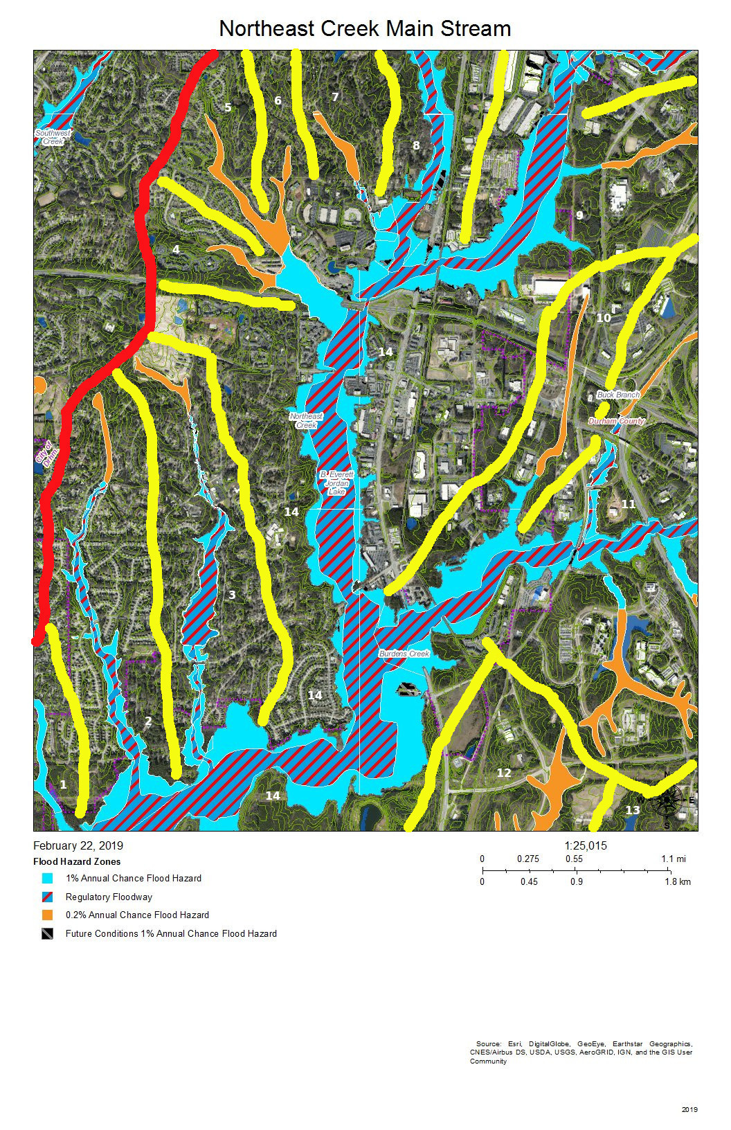
To do that, we must perceive streams and their tributary flows of runoff (the water) in the foreground and land in the background. Focusing on the flash flood zones at full flood (the flood zones identified on the maps) shows the land as necks extending into the fully flooded lake headwaters. After all, one of the primary purposes of Lake Jordan was mitigation of the flash flooding that often occurred in the Haw River and New Hope Creek basins.
The coloring of the flood zones represent the following:
Solid blue: 1% annual chance flood hazard
Blue with red diagonal stripes: Regulatory floodway
Gold: 0.2% annual chance flood hazard
Black with gray diagonal stripes: Future conditions 1% annual chance flood hazard.
A previous post showed that Parkwood comprises parts of three sub-basins:
The main stream of Northeast Creek on the east;
Tributary C feeding Parkwood Lake in the center;
Tributary D draining the western part of the McCormick high land and streams from Hunters Woods joining and running down Wineberry to the west.
This post presents maps to help find the path that the water takes from the roof of a particular house to Tributary C of Northeast Creek, which feeds the Parkwood Lake. Future posts will look at Tributary D and the main stream of Northeast Creek.
Skim through the maps to the part of Tributary C that you want to examine and then click on the map to enlarge. To enlarge further use the + keys in your viewer or Ctrl-+ on the keyboard. There will be some street references in the text following each map.
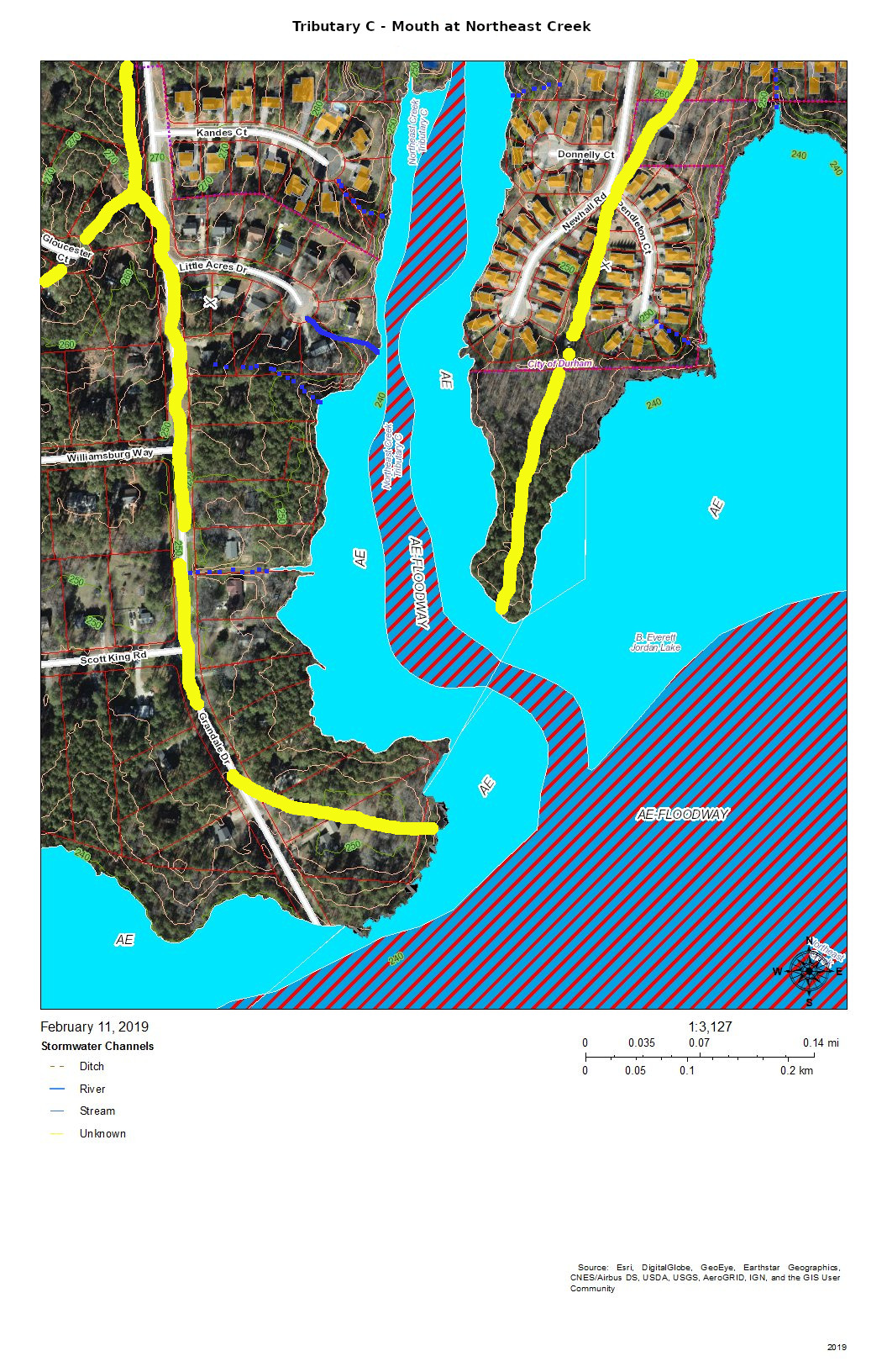
Yellow lines mark the sub-basins of Tributary C. Blue lines are the creeks in the area in the map title. Dotted blue lines are intermittent creeks inferred from the topography or known significant stormwater pipes. The impervious surfaces of roofs are orange, and the impervious surfaces of parking lots, driveways, and other concrete structures are gray.
Looking from the mouth of Tributary C and Northeast Creek, the sequence of maps examines each upstream branch and the main stream of Tributary C back to its source near NC 54.
Mouth of Tributary C at Northeast Creek
The mouth of Tributary C is a wetland flood plain that cycles between swamp forest in drier times and then snags (dead trees that are habitat for wildlife) and freshwater marsh in wetter times. You can see this same sort of landscape on the north side of NC 54 by Woodcroft Shopping Center.
Runoff from the roofs and drives flows through the yards or down the streets to the cul-de-sacs and down slopes into the bottomlands.
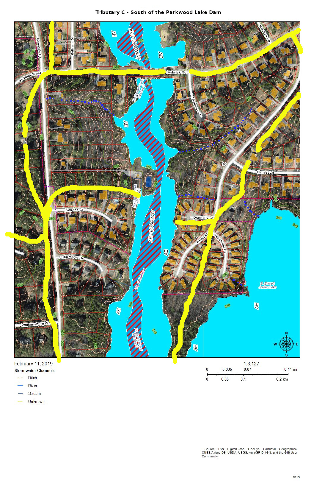
Tributary C South of the Parkwood Lake Dam
The main stream south of Parkwood Lake comes down the spillways from the lake through woods, under Sedwick Road, and into the bottomlands. An intermittent stream drains the runoff from the houses on Dedmon Court, Donnelly Court, Newhall Road, and Sedwick Road. An intermittent stream on the west side of the bottomlands drains the runoff from two houses on Sedwick Road and one on Grandale Road.
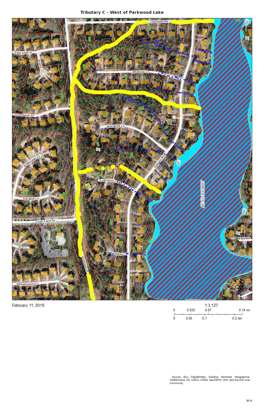
Tributary C as Parkwood Lake and the West Side Headwaters
The runoff from the houses on the west side of Parkwood Lake primarily flows down the streets, across Pelham Road and into the lake. The runoff from the houses on lake flows directly into the lake.
The runoff from the east side of Grandale Road just north of Sedwick Road is directed into the ditch on the north side of Sedwick Road and is a part of this section of Tributary C.
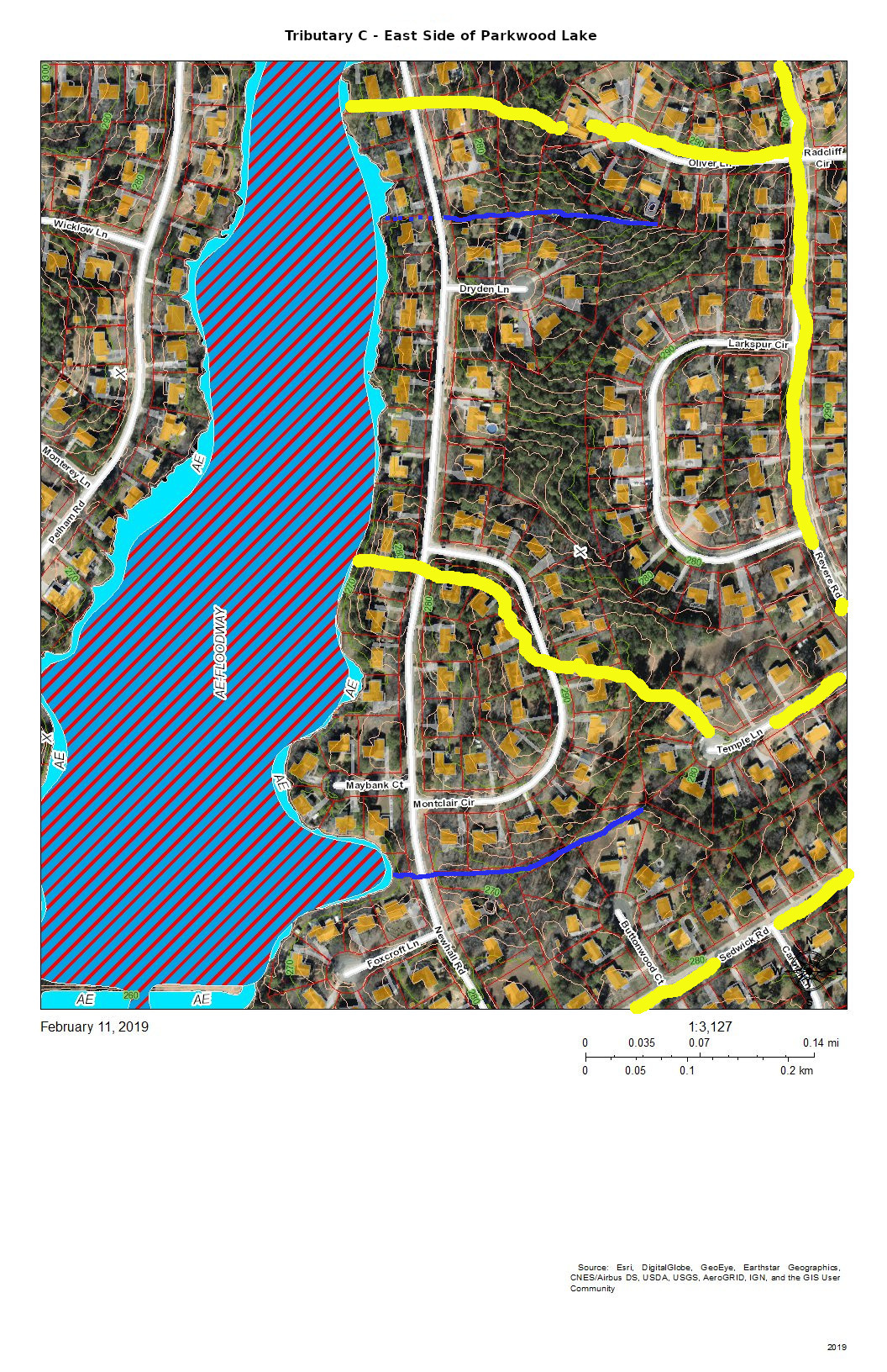
Tributary C – East Side of Parkwood Lake
The east side of Parkwood Lake drains the west side of Revere Road and Larkspur Circle in addition to the houses along Newhall Road and the lakefront houses. There seem to be two more-or-less permanent streams draining from either corner of Larkspur Circle. There is significant Parkwood common land in the center of this block that aids in soaking up rainfall from Larkspur Circle and Revere Road. Another stream drains Temple Lane and Buttonwood Court.
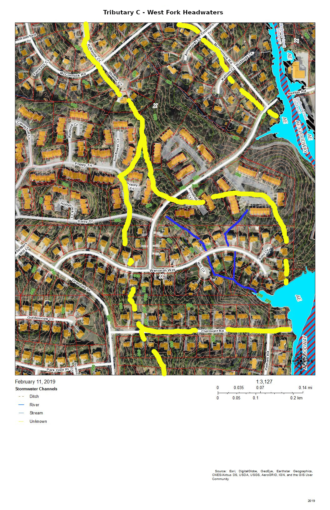
Tributary C West Fork Headwaters
The west fork headwaters drain part of The Ridges of Parkwood, part of Parkwood Village, and some of the houses on Wenonah Way, Runoff from the west fork headwaters flow directly into the Parkwood Lake forebay (former lotus pond).
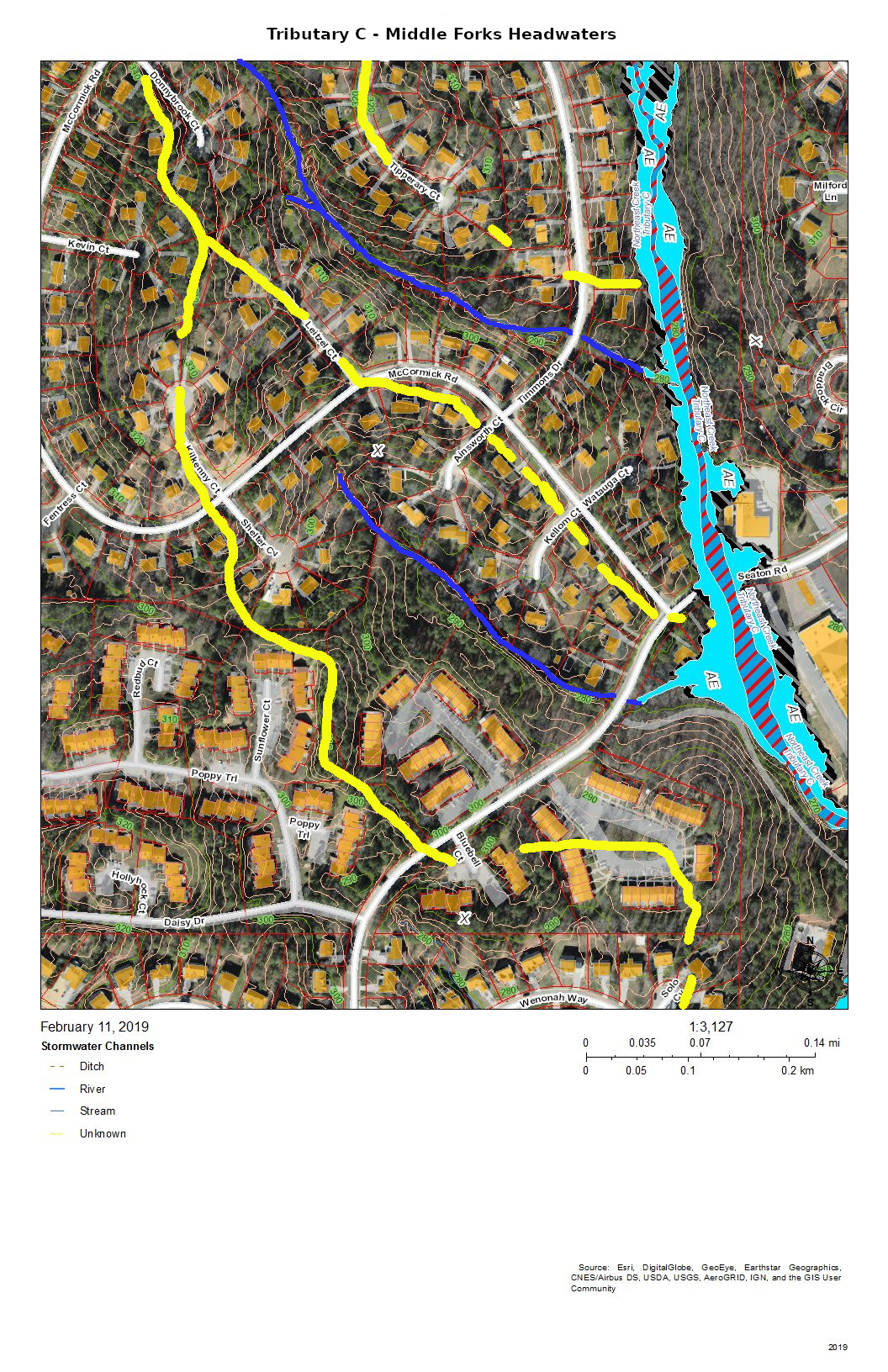
Tributary C – Middle Forks Headwaters
The headwaters of the two middle forks of Tributary C drain the southeast side of the McCormick Road highland. The southernmost of the two middle forks drains most of Parkwood Village.
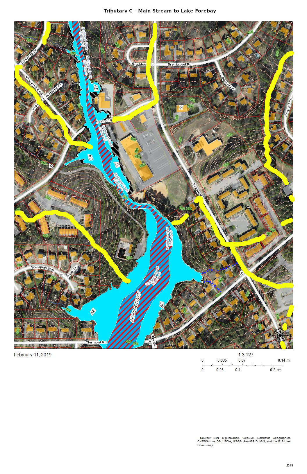
Tributary C – Main Stream to Lake Forebay (former Lotus Pond)
This section of Tributary C shows the main stream in the area of the trail from the Parkwood ballfield to the Parkwood Lake forebay (former lotus pond). The lower section is a significant bottomland that has a variety of interesting native plants such as magnolia, red maple, and native honeysuckle with hearts-a-bustin’, pussytoes, wild oregano, and lyre-leaf sage in the uplands.
Tributary C – Drainage from East of Revere Road
The area of Tributary C east of Revere Road mostly drains through stormwater pipes the run under the parking lot of Jamaat Ibad Ar-Rahman mosque (former Parkwood Shopping Center). The stormwater pipes converge and empty through a single pipe outlet to Tributary C opposite Parkwood Village’s road to its swimming pool (the Pool in the Woods). This area drains from the hill on Brentwood Road near Bradley Circle and an area north of Brentwood Road almost to Travis Circle. It also drains the slope behind Parkwood United Methodist Church and the apartments up to the parcel that was set aside in the original design for a water tower and conveyed in that designation to the Parkwood Association. (In 1961, there were no city water and sewer services this far out. The Parkwood subdivision had a private utility that provided water from wells and owned and operated the package sewage plants.)
This elaborate stormwater system is the legacy of the philosophy of controlling stormwater that was prevalent at the beginning of the 1960s — pipe it away. The site preparation for “Parkwood Center”, the commercial and institutional core of the community froze some of the original stream system into the landscape while concentrating the flow under parking lots into a single stream. The object was to dump the excess water as fast as possible into Tributary C. After almost sixty years we can see that that strategy leads to stream scour and transportation of soil down the creek system. And creates erosional undercutting of the stream bank opposite the single stormwater pipe outlet.
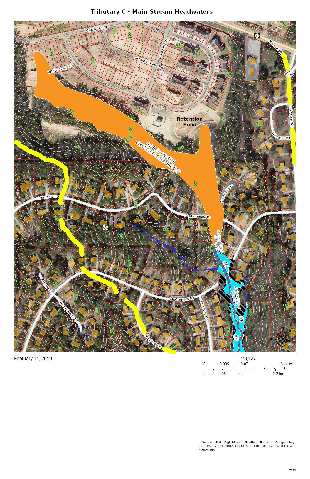
Tributary C – Headwaters of Main Stream
The headwaters of Tributary C lie completely south of NC 54 because NC 54 was built on a ridge between two tributaries of Northeast Creek and because subsequent engineering of the highway has sharpened the separations of the drainage. The headwaters now are developed as the Meadows at Southpoint, a town home community that uses regulation-permitted retention ponds instead of open space to manage run-off from its newly constructed houses, driveways, sidewalks, roads, and other impervious surfaces.
During construction, the Parkwood community experienced the fact that regulations are based on normal patterns of rainfall for construction of retention ponds. When there was a pattern of heavy rainfall, the retention ponds released sediments, particularly colloidial clay, into Tributary C; that turned the Parkwood Lake brown.
Residents in the Auburndale Drive-Lamarck Court area were among the first to notice the sediments because they monitor their nearby creeks.
In principle, with the completion of construction, the permanent retention ponds will prevent a recurrence. Continued citizen monitoring of their local creeks is the principal way of catching these situations early enough. And this is true for all of the streams draining into Northeast Creek.
That is why Northeast Creek Streamwatch is encouraging Upstream Neighbors/Downstream Neighbors, a volunteer program of monitoring neighborhood streams and conservation on your own property to harvest rainwater, conserve topsoil, and absorb water during abnormal rainfall.
Having attention on the portion of water flow from your house to the nearest creek is a critical part of what gets sent downstream.
Creek Week is coming March 13 through 20. During that week Durham is focusing attention on how individual citizens and property owners can with modest efforts deliver significant benefits to the quality of water moving downstream, especially to Jordan Lake.
A fun activity during Creek Week is to find the path that water from your roof, sidewalk, driveway, and patio or deck takes as it goes to Northeast Creek, down Northeast Creek and into Jordan Lake, and down the Cape Fear River to Wilmington.
To do that, we must perceive streams and their tributary flows of runoff (the water) in the foreground and land in the background. Focusing on the flash flood zones at full flood (the flood zones identified on the maps) shows the land as necks extending into the fully flooded lake headwaters. After all, one of the primary purposes of Lake Jordan was mitigation of the flash flooding that often occurred in the Haw River and New Hope Creek basins.
The coloring of the flood zones represent the following:
Solid blue: 1% annual chance flood hazard
Blue with red diagonal stripes: Regulatory floodway
Gold: 0.2% annual chance flood hazard
Black with gray diagonal stripes: Future conditions 1% annual chance flood hazard.
A previous post showed that Parkwood comprises parts of three sub-basins:
Tributary D draining the western part of the McCormick high land and streams from Hunters Woods joining and running down Wineberry to the west.
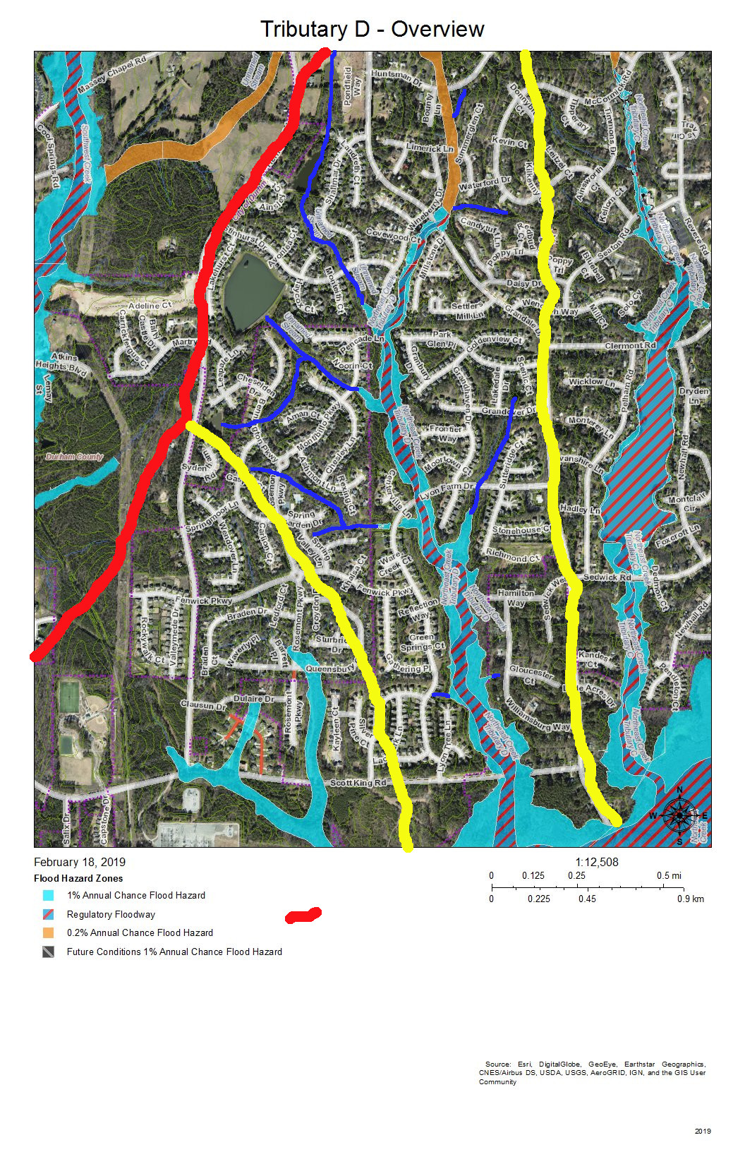
This post presents maps to help find the path that the water takes from the roof of a particular house to Tributary D of Northeast Creek, which feeds the Parkwood Lake. Future posts will look at the main stream of Northeast Creek.
Here is an overview of Tributary D:
Overview of the Tributary D sub-basin
On this map, the red line is the boundary with the Crooked Creek basin. The yellow lines mark the sub-basin of the west fork of Tributary D and the dividing ridge along Grandale that separates Tributary D from Tributary C.
Skim through the maps to the part of Tributary D that you want to examine and then click on the map to enlarge. The sections with streams with blue solid or dotted lines are the section of Tributary D that for which the map is a guide, To enlarge further use the + keys in your viewer or Ctrl-+ on the keyboard. There will be some street references in the text following each map.
Yellow lines mark the sub-basins of Tributary D. Blue lines are the creeks in the area in the map title. Dotted blue lines are intermittent creeks inferred from the topography or known significant stormwater pipes. The impervious surfaces of roofs are orange within the City of Durham, and the impervious surfaces of parking lots, driveways, and other concrete structures are gray, also within the City of Durham. Outside the City of Durham in Durham County, with the image enlarged enough you can generally understand where roofs, driveways and sidewalks are.
Looking from the mouth of Tributary D and Northeast Creek, the sequence of maps examines each upstream branch and the main stream of Tributary D back to its source near the pond in Hunters Woods.
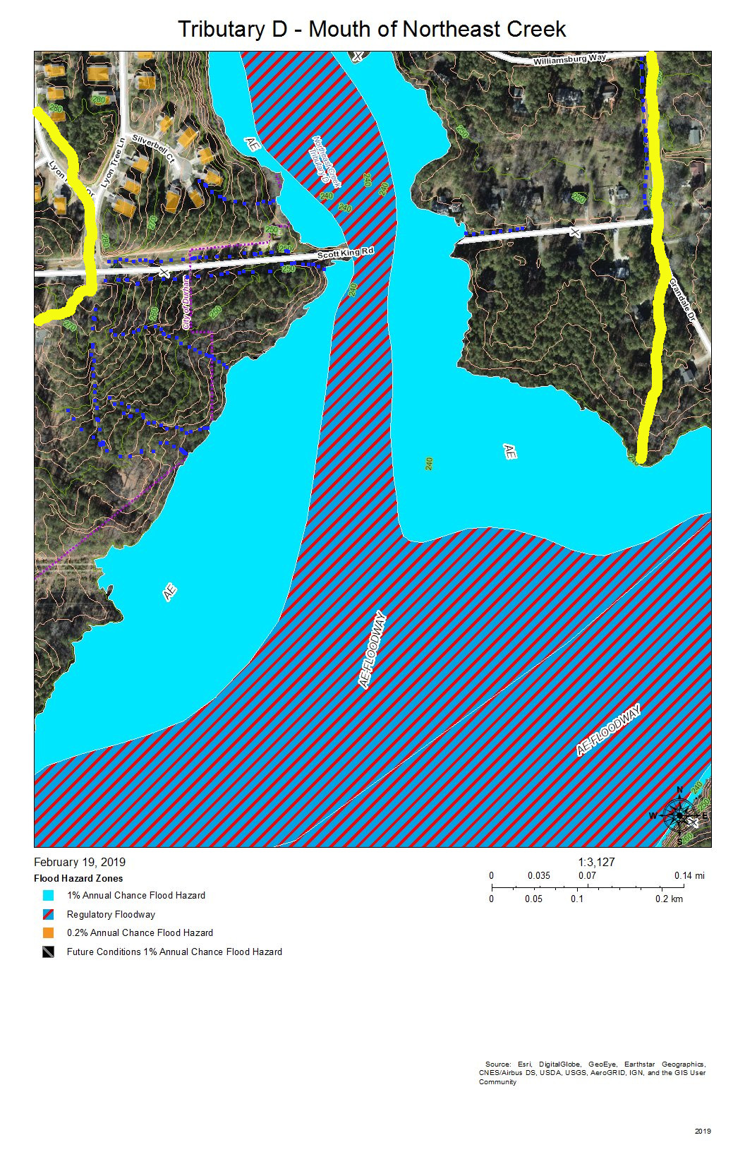
Tributary D – Mouth at Northeast Creek
Almost all of the section floodway of Tributary D in this map of the map is in US Army Corps of Engineers land surrounding the headwaters of Lake Jordan. This property does extend north of Scott King Road.
The drainage channels shown on this map are primarily intermittent streams that flow down the swales on either side of Scott King Road and intermittent streams flowing down slopes into Tributary D.
This is an area in which we have cleaned out tires from Corps of Engineers property in past clean-ups.
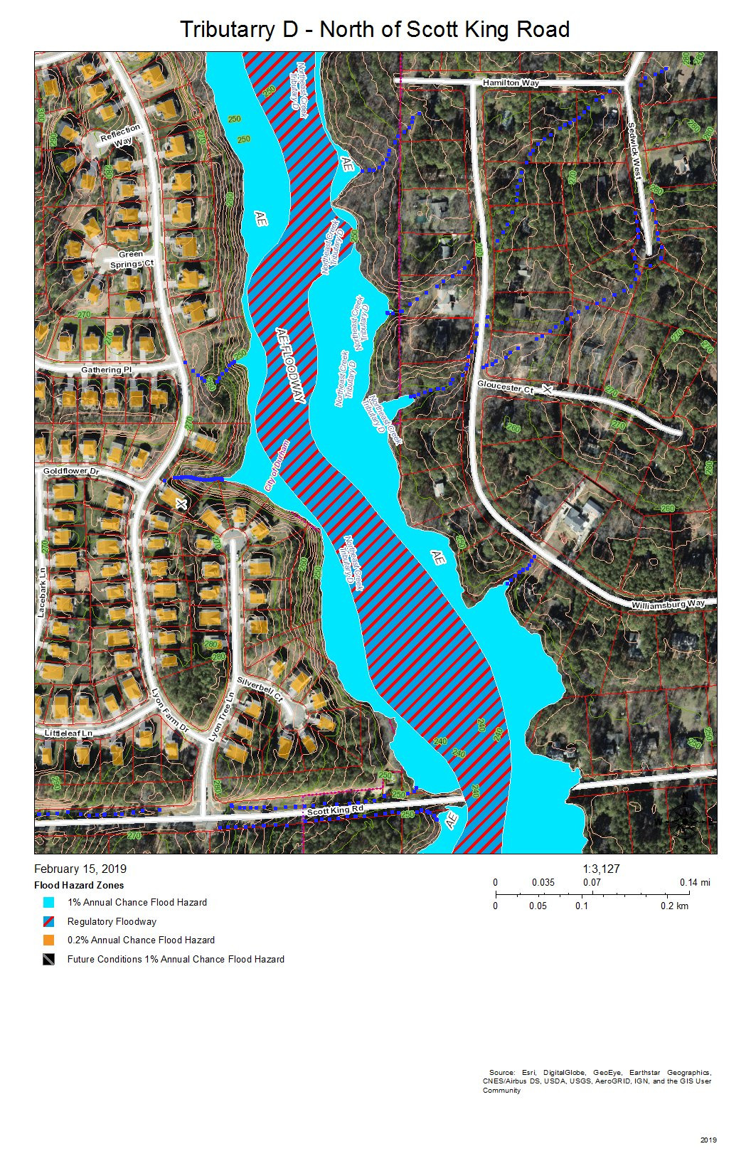
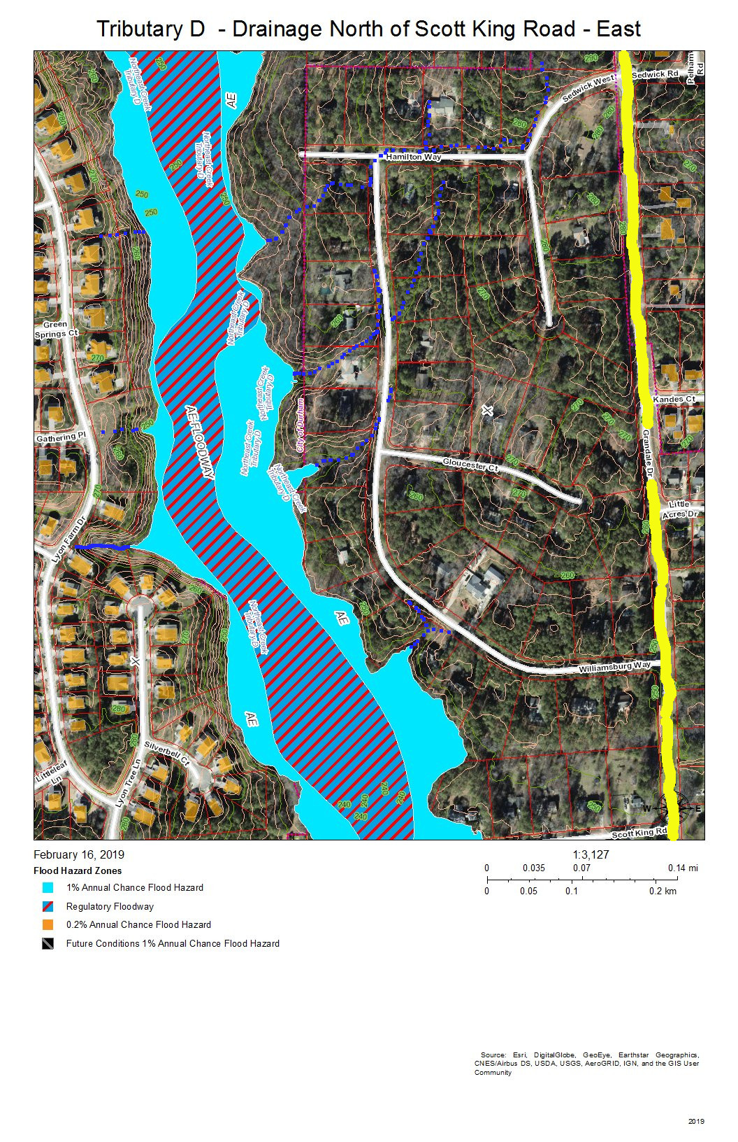
Tributary D Main Stream – North of Scott King Road
This section of Tributary D is between Lyons Farm on the west and Lake Park on the East. Most of the drainage is from runoff down the slopes, from stormwater pipes not shown on this map, or from the intermittent streams at various points on the stream bank.
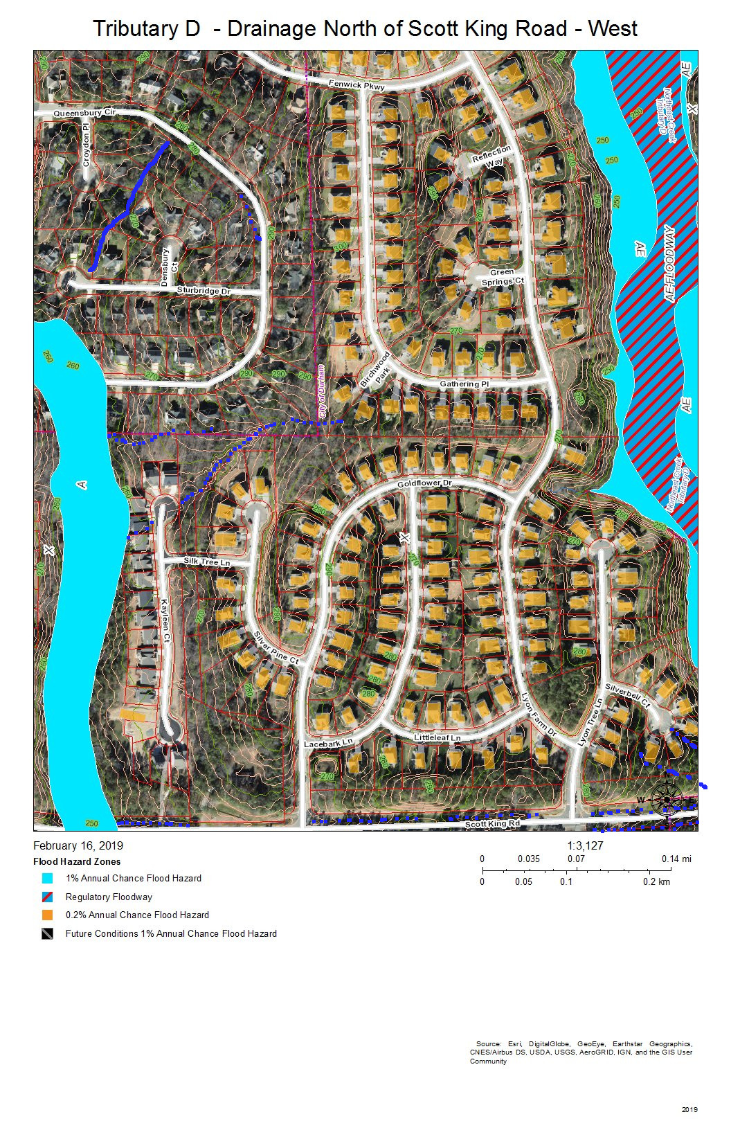
Tributary D – Drainage from West Bank North of Scott King Road
Fairfield, Grandale, and Lyons Farm are the neighborhoods between Tributary D on the east and a fork of Tributary D on the west that crosses Scott King Road just west of Goldflower Drive and joins the Tributary D wetland in Corps land.
East Bank of Tributary D North of Scott King Road
Lake Park is the neighborhood on the east bank of Tributary C north of Scott King Road. Drainage is from intermittent streams or stormwater pipes not shown on this map.
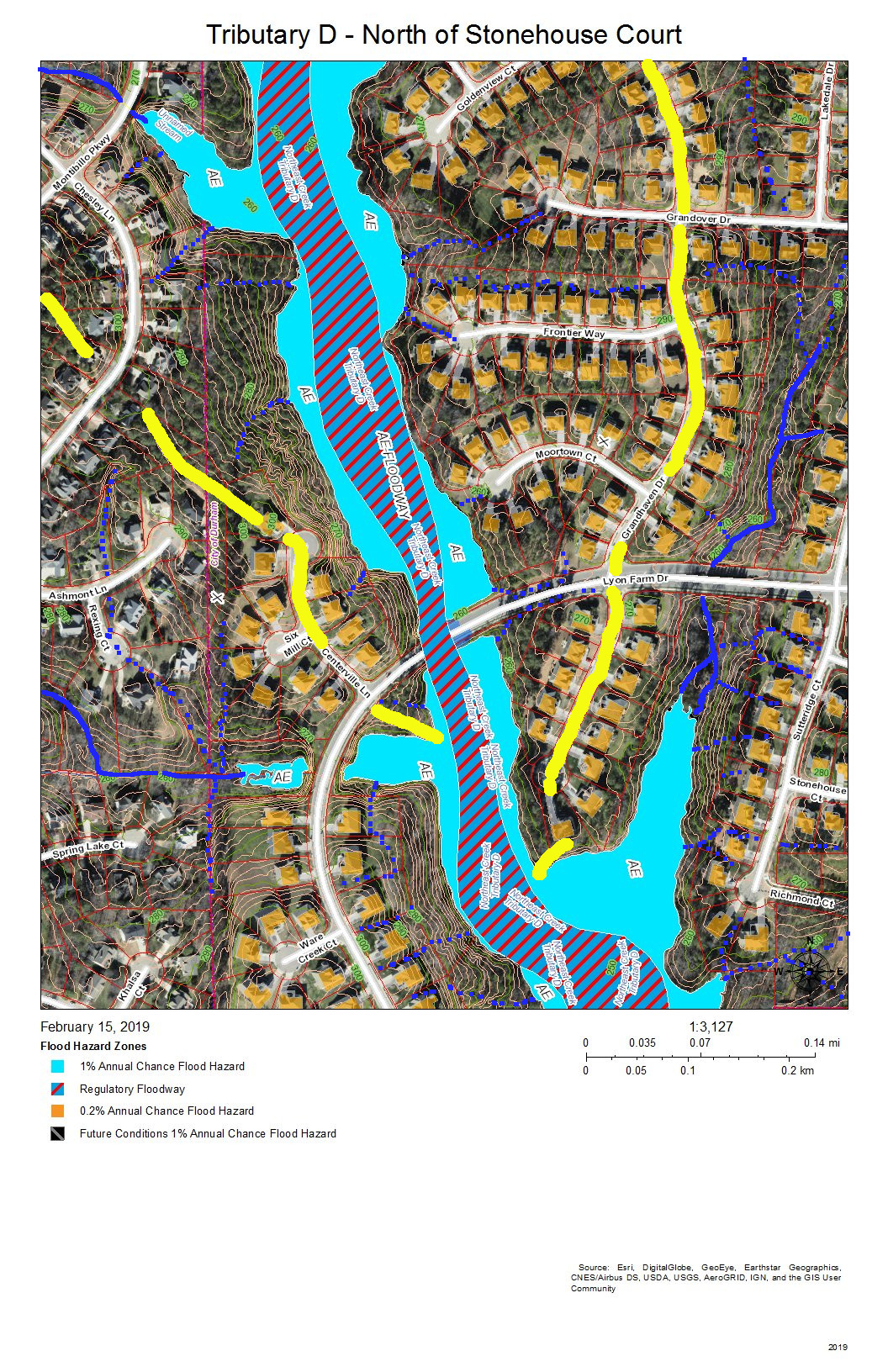
Tributary D – Main Stream North of Stonehouse Court
Fairfield, Grandale, and Grandale Place are the neighborhoods where the main stream of Tributary D meets some of its own tributaries.
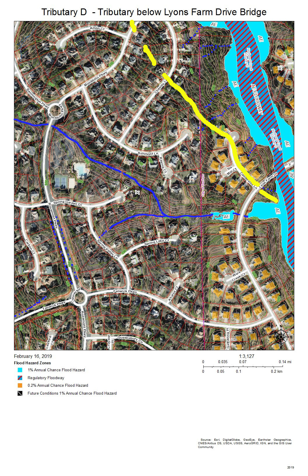
The west bank of Tributary D below the bridge for Lyons Farm Drive.
Fairfield and Grandale are the neighborhoods on this section of Tributary D. A tributary stream crosses under Rosemont Parkway just south of the circle on Montibillo Parkway. The yellow line marks the watershed ridge separating the main stream of Tributary D from this tributary.
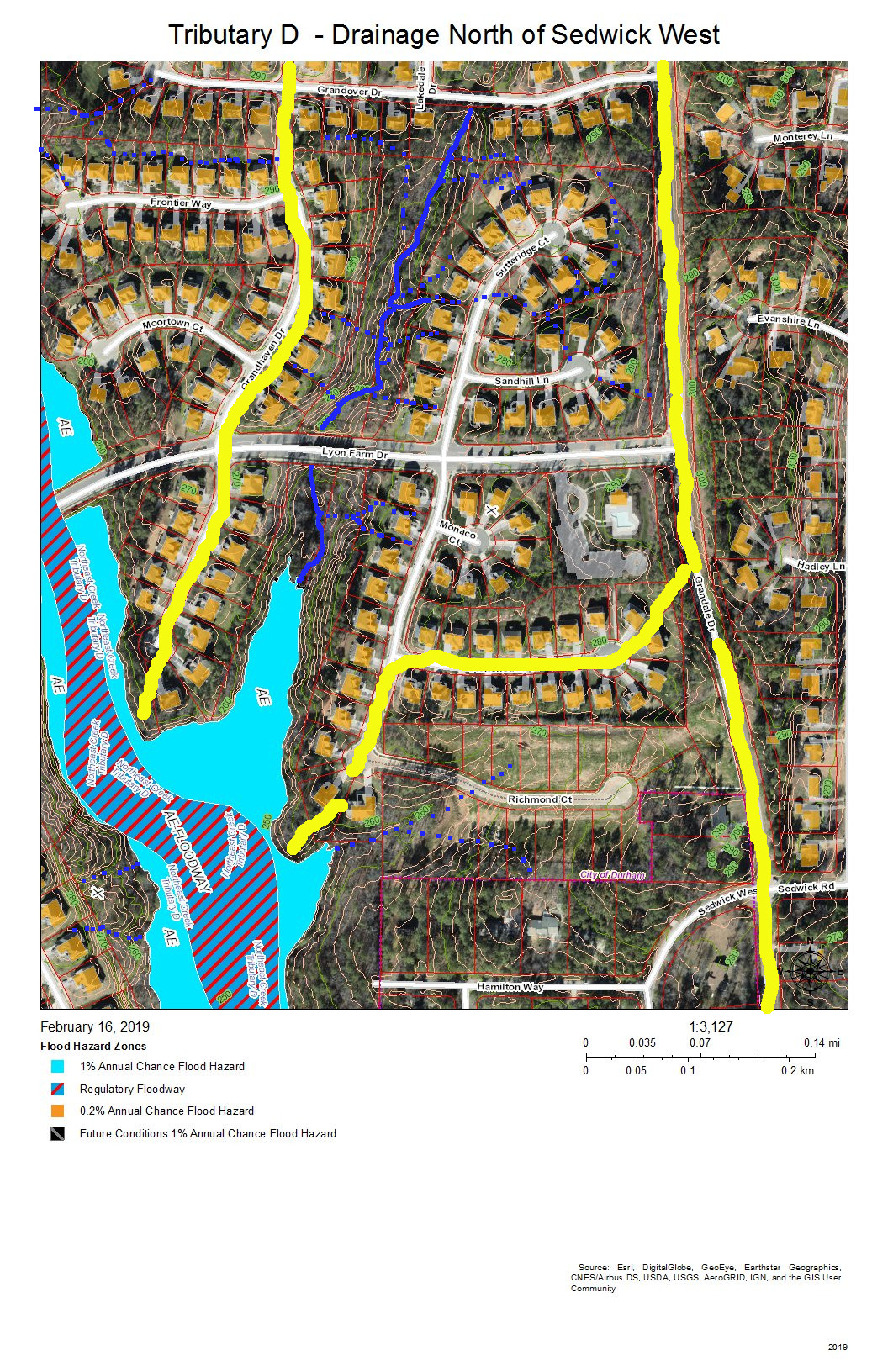
Tributary D Drainage – East Bank North of Sedwick West
Grandale is the neighborhood in this view, and the neighborhood building at the entrance from Grandale Drive is the one with the L-shaped parking lot. The yellow line along Grandale marks the watershed ridge with Tributary C. The other yellow lines outline the sub-basin of the tributary from Grandover Drive that joins the main stream of Tributary D in this view. Other drainage is from intermittent stream (dotted blue lines) or stormwater pipes not visible on this map.
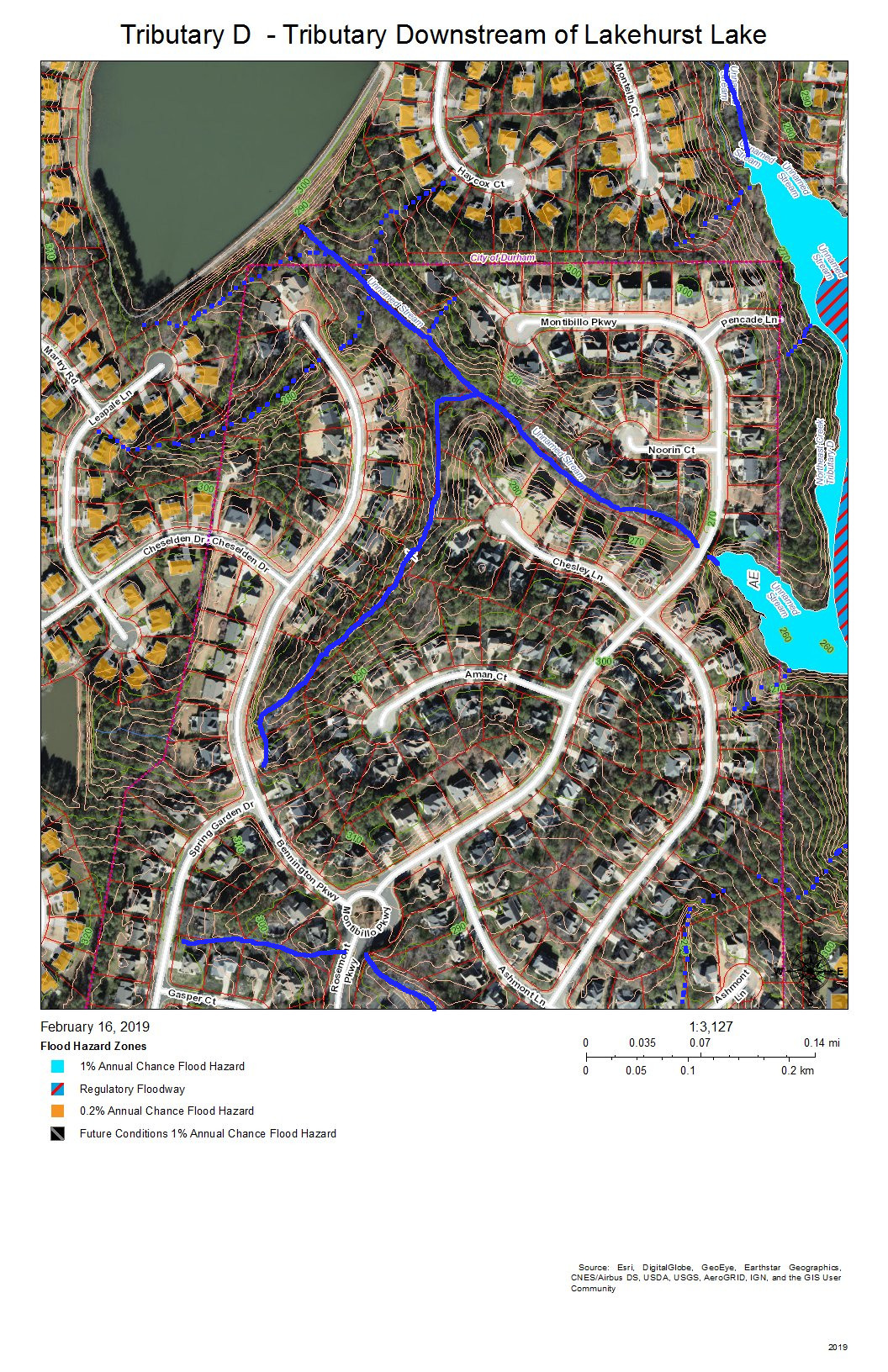
Tributary D Downstream from Lakehurst Lake
Fairfield and Lakehurst are the neighborhoods in this view. The lake in the Lakehurst neighborhood dams the tributary that flows into Tributary D and that acts somewhat like a retention pond moderating wet and dry weather patterns. Elsewhere, intermittent streams and stormwater pipes not visible on this map drain the runoff from development into the tributary streams.
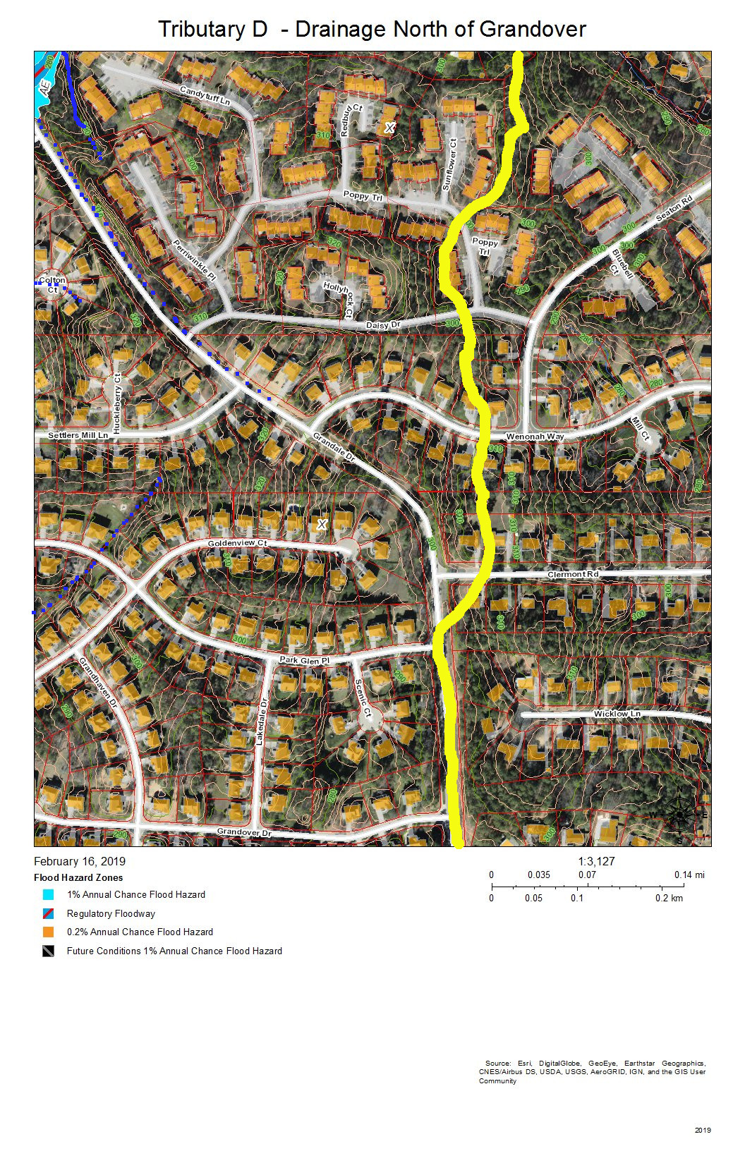
Tributary D – Drainage North of Grandover Drive
Grandale Place, Settlers Mill, and the Ridges at Parkwood are the neighborhoods in this view. The drainage flows through stormwater pipes not visible on the map and down intermittent streams (marked with blue dots).
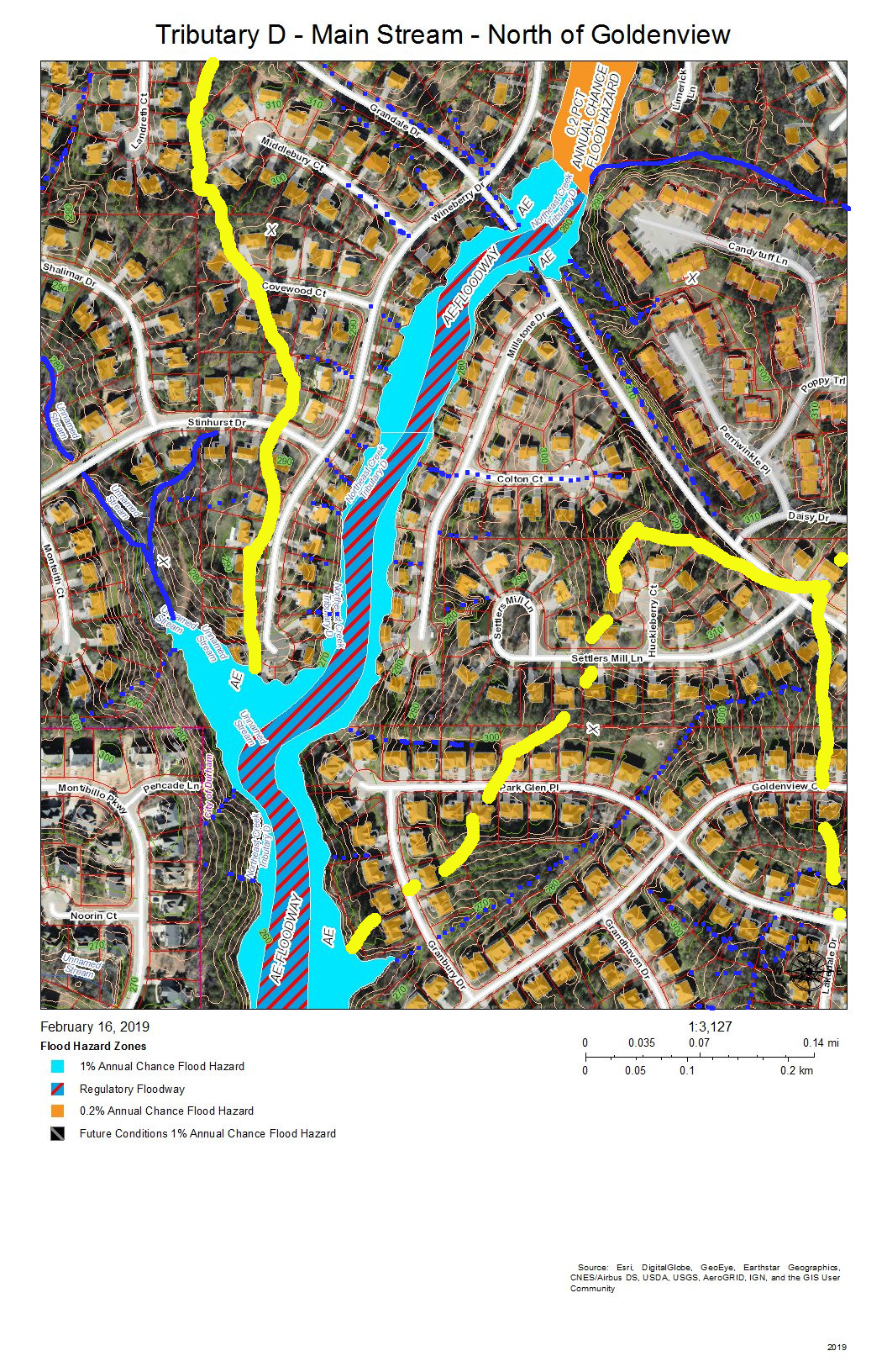
Tributary D Main Stream – North of Goldenview Drive
Grandale Place, Settlers Mill, Grandale Forest, and Lakehurst are the neighborhoods in this view. The yellow line at the top is the watershed ridge separating the fork that drains north of Stinhurst Drive from the main stream. The other yellow line shows the sub-basin of the tributary intermittent streams that drain Grandale Place; this might be supplemented with stormwater pipes not shown on this map.
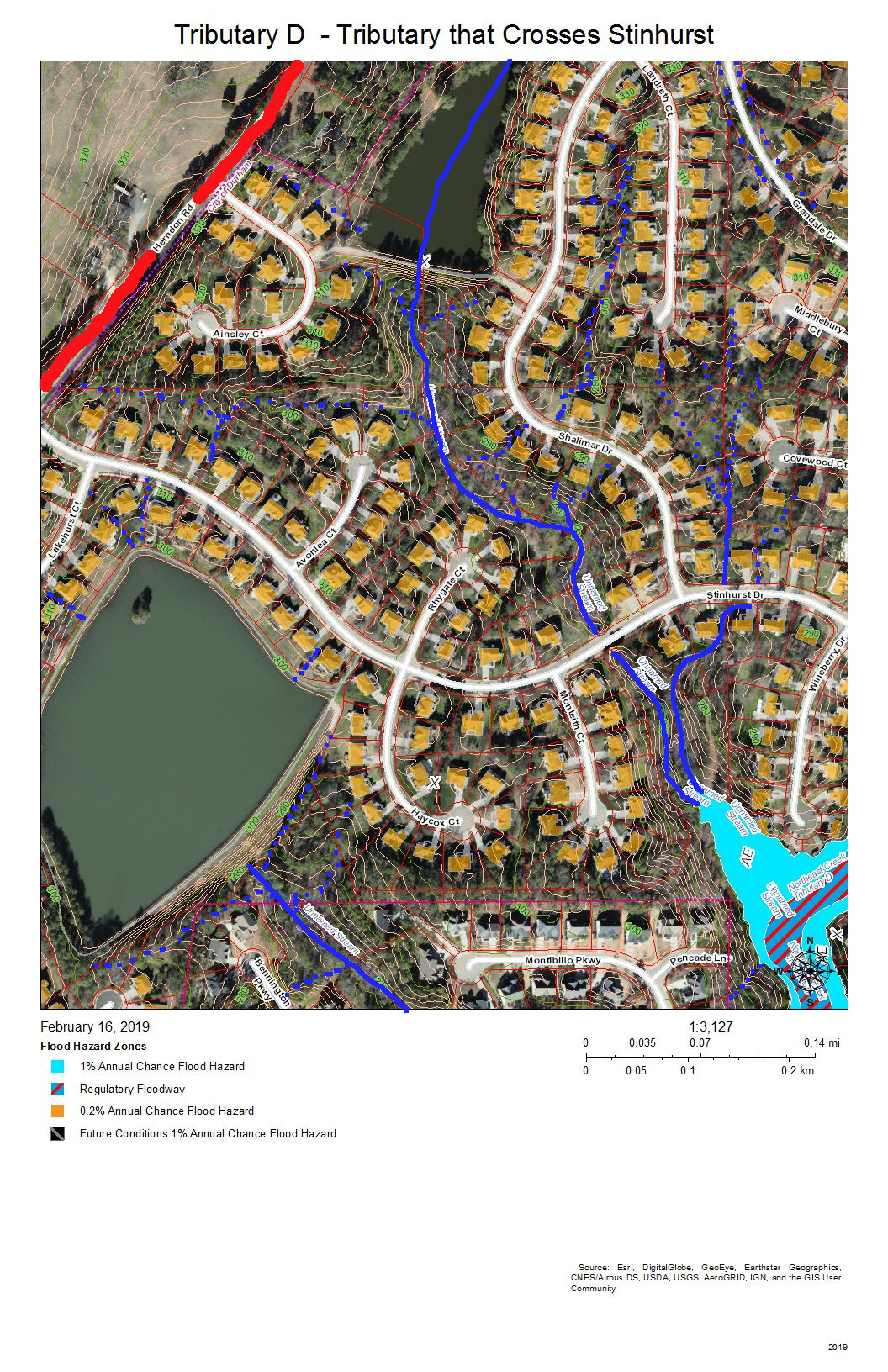
Tributary D – Tributary That Crosses Stinhurst Drive
Lakehurst Pointe and Lakehurst are the neighborhoods in this view. The red line shows the watershed ridge between the Northeast Creek basin and the Crooked Creek basin. Two tributaries of Tributary D join the main stream beyond the cul-de-sac at the end of Wineberry Drive. One of these originates above the lake in Lakehurst Pointe; the other originates between the cul-de-sacs of Landreth Court and Middlebury Court in Lakehurst Pointe.
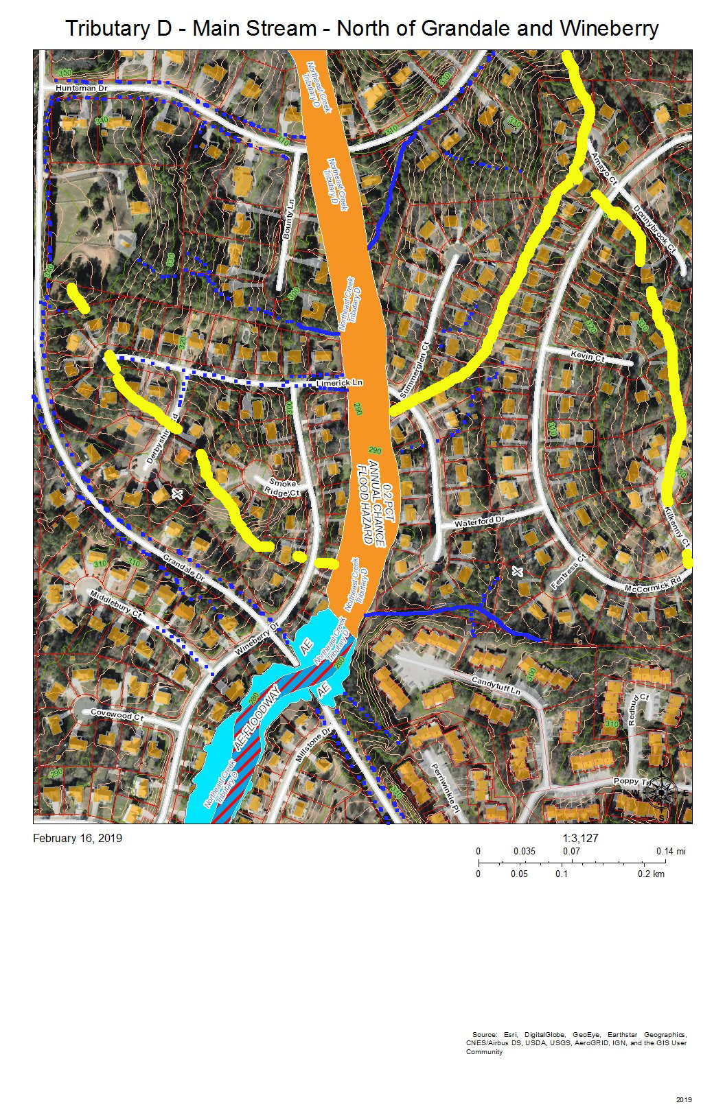
Tributary D Main Stream North of the Intersection of Grandale Drive and Wineberry Drive
Grandale Forest and Parkwood are the neighborhoods in this view. The intersection of Grandale Drive and Wineberry Drive are the point at which a tributary from the southwestern section of McCormick Road, an intermittent creek from the Ridges, and the intermittent creeks that flow down the swales on either side of Grandale Drive merge before crossing through two 4-foot pipes under Grandale Drive and flowing behind the houses on Wineberry Drive. Over 20 years, the section of creek along Wineberry Drive has scoured almost four feet of depth in the streambed, and water still overflows into yards in heavy rains.
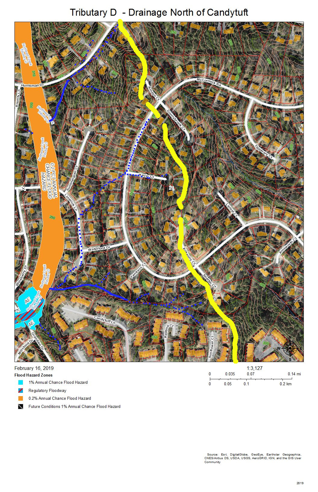
Tributary D – Drainage North of Candytuft Lane
The Ridges of Parkwood, Parkwood, and Hunters Woods are the neighborhoods in this view. The yellow line marks the watershed ridge between Tributary D and Tributary C. Two tributary streams drain this area–one south of Huntsman Drive and one north of Candytuft Lane. An intermittent stream drains the west side of the McCormick highlands and flows down McCormick Road. Another intermittent stream flows down Limerick Lane.
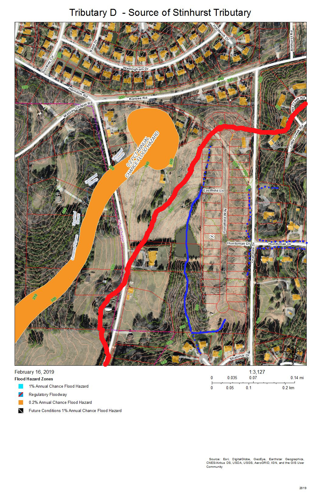
Tributary D – Source of the Tributary Stream from Lakehurst Pointe Lake
Lakehurst Pointe and Grandin Trace are the neighborhoods in this view. The red line is the boundary between Tributary D and the Crooked Creek basin. The source is in what is soon to be the northwest corner of Grandin Trace and flows into a pond that releases a stream that flows openly and then through stormpipes into the lake in Lakehurst Pointe.
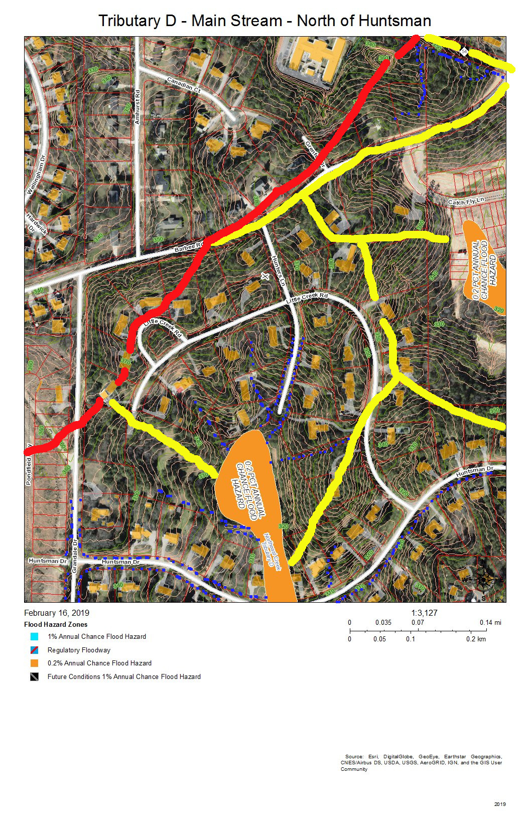
Tributary D – Main Stream North of Huntsman Drive
Hunters Woods is the neighborhood in this view. The yellow lines on the east are two sub-basins of tributaries of Tributary C that drain the Meadows at Southpoint. The red line is the watershed ridge between Crooked Creek and Northeast Creek. The yellow line along Barbee Road is the drainage off of Barbee Road that road construction has shifted from the Northeast Creek basin to the Crooked Creek basin. A local high point (elevation over 380 feet) was the site of a NC Forest Service fire tower until shortly before Hunters Wood was developed. This high point allow a ranger to see many square miles of woodlands cultivated on the uplands and bottomlands of Northeast Creek and Crooked Creek.
Tributary D – Drainage North of McCormick Road
Parkwood and Hunters Woods are the neighborhoods in this view. The yellow line marks the watershed ridge between Tributary D and Tributary C. The orange in Tributary C is the 0.2 percent chance flood zone in the headwaters of the Meadows at Southpoint retention pond. The orange in Tributary D is the Hunters Woods lake and the overflow path if the dam is topped; this is also a 0.2 percent chance flood zone.
All of the maps in this series are works in progress that need investigation by residents of the neighborhoods reporting what they see on the ground. There are many points that are not clear from aerial views about how the drainage flows. One issue in particular is how the retention pond from Grandin Trace flows into the lake in Lakehurst Pointe. As we get corrections we can edit the maps to apply them and eventually have maps to provide an atlas of the Tributary D basin.
Creek Week is coming March 13 through 20. During that week Durham is focusing attention on how individual citizens and property owners can with modest efforts deliver significant benefits to the quality of water moving downstream, especially to Jordan Lake.
A fun activity during Creek Week is to find the path that water from your roof, sidewalk, driveway, and patio or deck takes as it goes to Northeast Creek, down Northeast Creek and into Jordan Lake, and down the Cape Fear River to Wilmington.
To do that, we must perceive streams and their tributary flows of runoff (the water) in the foreground and land in the background. Focusing on the flash flood zones at full flood (the flood zones identified on the maps) shows the land as necks extending into the fully flooded lake headwaters. After all, one of the primary purposes of Lake Jordan was mitigation of the flash flooding that often occurred in the Haw River and New Hope Creek basins.
The coloring of the flood zones represent the following:
Solid blue: 1% annual chance flood hazard
Blue with red diagonal stripes: Regulatory floodway
Gold: 0.2% annual chance flood hazard
Black with gray diagonal stripes: Future conditions 1% annual chance flood hazard.
A second fun activity is to explore the wetlands on US Army Corps of Engineer land set aside for the headwaters of Jordan Lake. The wetlands in these areas comprise:
periodic flood plains that flood with every rain and become dry land with every dry spell;
freshwater marshes;
periodic swamp forests;
persistent swamp forests that give way to snags (dead trees that host animals like woodpeckers) then become pools of blow-downs (blown-over dead trees);
tightly meandering stretches of stream;
braided streams;
oxbow ponds.
These organize themselves to best handle the flow of water through the wetlands in wet and dry periods.
On the maps, wetland features are marked with dotted blue and orange lines.
A previous post showed that Parkwood comprises parts of three sub-basins:
Tributary D draining the western part of the McCormick high land and streams from Hunters Woods joining and running down Wineberry to the west.
This post presents maps to help find the path that the water takes from the roof of a particular house to the main stream of Northeast Creek and the features of the Northeast Creek wetlands that it passes through. Future posts will look at what you can do on your own property to help preserve effective functioning of Northeast Creek.
The following map is an overview of the Northeast Creek main stream from Carpenter-Fletcher Road downstream to the American Tobacco Trail bridge over Northeast Creek on the trail a half mile south of the Scott King Road trailhead.
The red line is the watershed ridge on the west between the Northeast Creek basin and the Crooked Creek basin.
Main Stream – Overview
From left to right the sub-basins of Northeast Creek are:
A fork that arises in the Southhampton neighborhood and the edge of C. M. Herndon Park on Scott King Road;
Tributary D;
Tributary C;
A tributary that runs from the Legacy at Meridian;
A tributary that runs out of the Auburn neighborhood;
A tributary that crosses Woodcroft Parkway east of Barbee Road;
A tributary that flows into Meridian Park;
The North Prong of Northeast Creek, the major tributary that flows down the west side of NC 55 and through Meridian Park;
The main stream (Northeast Prong) of Northeast Creek;
Buck Branch, which flow out of the old EPA campus area;
The north fork, main stream, and south fork of Burdens Creek, which drains the central section of Research Triangle Park;
Long Branch of Kit’s (Kitt’s) Creek;
Another branch of Kit’s Creek, which drains the southern section of Research Triangle Park.
Main stream of Northeast Creek.
This series of maps will show the western side (Parkwood side) of the main stream, that wide, blue and blue-and-red floodway that:
starts at the top right of the map,
flows south,
then west again in passing the Red Roof Inn on NC 55 north of I-40 and connecting with the North Prong in the southeast corner of Meridian Park,
then south again at the Doubletree Inn;
then it crosses under I-40 and flows through a wetland between Parkwood and NC 55;
Burdens Creek joins it from the east and Research Triangle Park;
then turns west flowing south of Audubon Park and Parkwood, through Corps of Engineers unforested land and a Duke Energy high-voltage line easement;
then it crosses under Grandale Road passing through forested Corps of Engineers land (NC Gameland);
it crosses into Chatham County;
Kit’s Creek joins it from the southeast and the southern part of Research Triangle Park;
it flows under the bridge for the American Tobacco Trail, a bicycle and pedestrian trail.
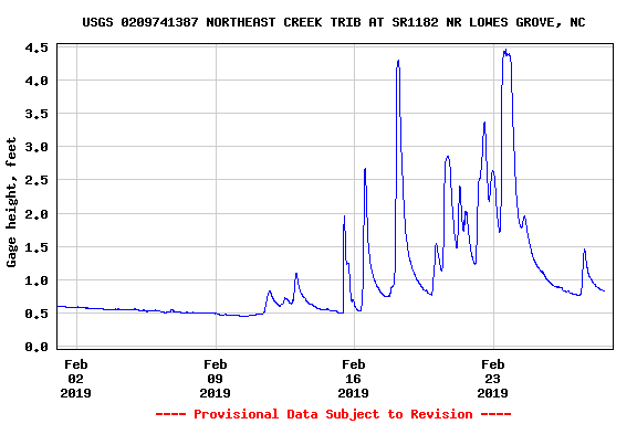
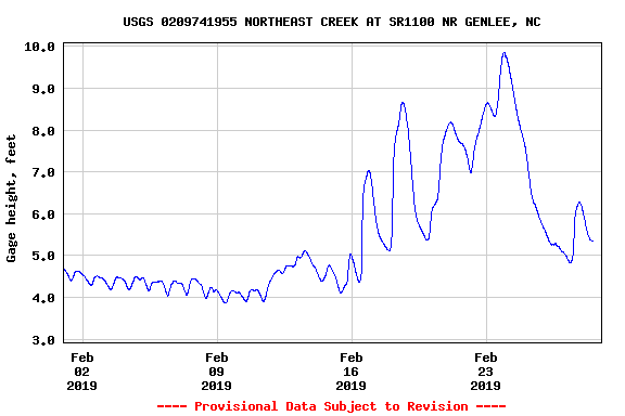
There are two stream gages placed by the US Geological Service on this section of Northeast Creek, one at Carpenter-Fletcher Road and the other at the bridge on Grandale Road. To provide a view of what this section of the main stream does, here is the February 2019 stream gage data for the Carpenter-Fletcher Road gage. Notice that the level during moderate periods is around 0.5 feet (6 inches), but rain quickly causes the level to rise to 2, the 2.5, then 4.5 feet. Remember these numbers when we come to the data from Grandale Bridge.
Stream Depth North Prong of Northeast Creek at Carpenter-Fletcher Road – February 2019
That stream gage is just upstream (north) on the North Prong (out of view off the top of this map).
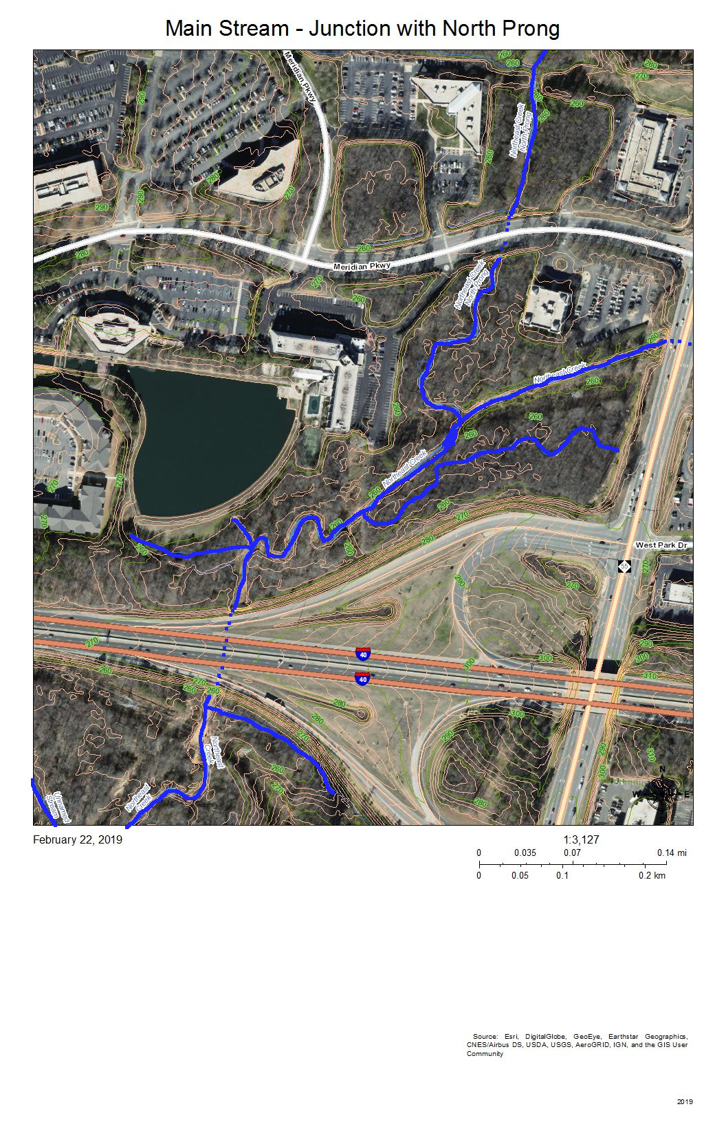
Junction of the North Prong of Northeast Creek with the Main Stream
The North Prong drains the Northeast Creek watershed south of Riddle Road and southwest of the intersection of Riddle Road and Alston Avenue. When it enters Meridian Park it flows into a wetland between NC 55 and Meridian Parkway (top right on the map).
Main Stream of Northeast Creek North of the NC 54 Bridge
I-40 appears at the top right of this map. The dotted blue line on I-40 is roughly where the culvert for Northeast Creek goes under I-40 and spills into the flood plain to the south. At the left end of NC 54 on the map is Christus Victor Lutheran Church; at the right end is Chik-Fil-A. The bridge is where the wetlands on the north side of NC 54 spill through to the south side of NC 54. This area regularly has high water during rainy spells.
Almost all of this wetland area except for the various stream channels is a wide intermittent flooded area during rainy spells. Drier weather allows for plant succession until water collects so frequently in those areas that it drowns out vegetation or gets replaced with water plants.
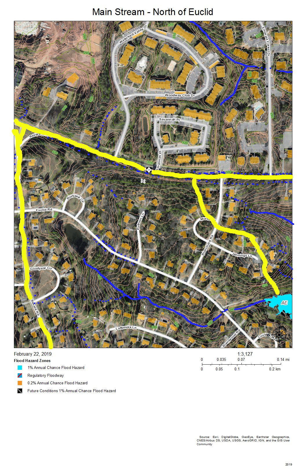
Main Stream North of Euclid Drive
The drainage of the sub-basin north of NC 54 gets directed parallel and south of I-40 and flows into the wetlands south of I-40 and north of NC 54 (in the previous map). The sub-basin on the top right has a stream that flows from the intersection of Blanchard Road and NC 54 southeast into the engineered pond behind the commercial buildings on NC 54. The third sub-basin flows out of the pond at the Revere Road end of Euclid Drive, between the houses on Lattimore Lane and Euclid Road, under Euclid Drive at the bottom of the hill, and down a restored stream that replaced a culvert and into the main stream of Northeast Creek in the wetlands.
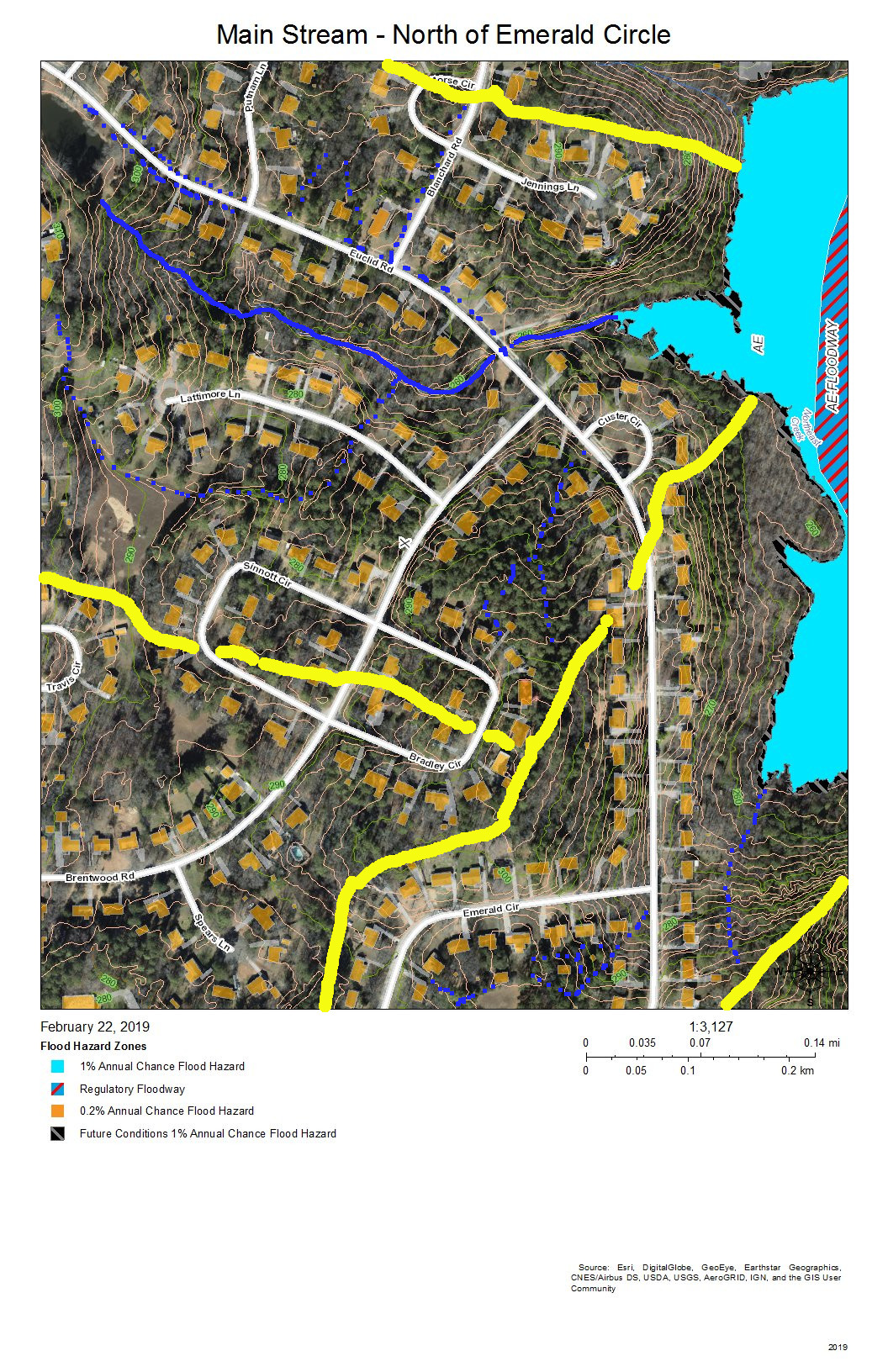
Main Stream North of Emerald Circle
The sub-basin at the top shows the drainage into the creek that flows from the pond at the Revere Road end of Euclid Drive and the creek that crosses Euclid Drive along the road to the former package sewer plant location (when Parkwood contracted its own private water and sewer service). The sub-basin at the bottom left is the area on Brentwood Road that flows into Tributary C. The remaining sub-basin is the intermittent stream that drains Emerald Circle.
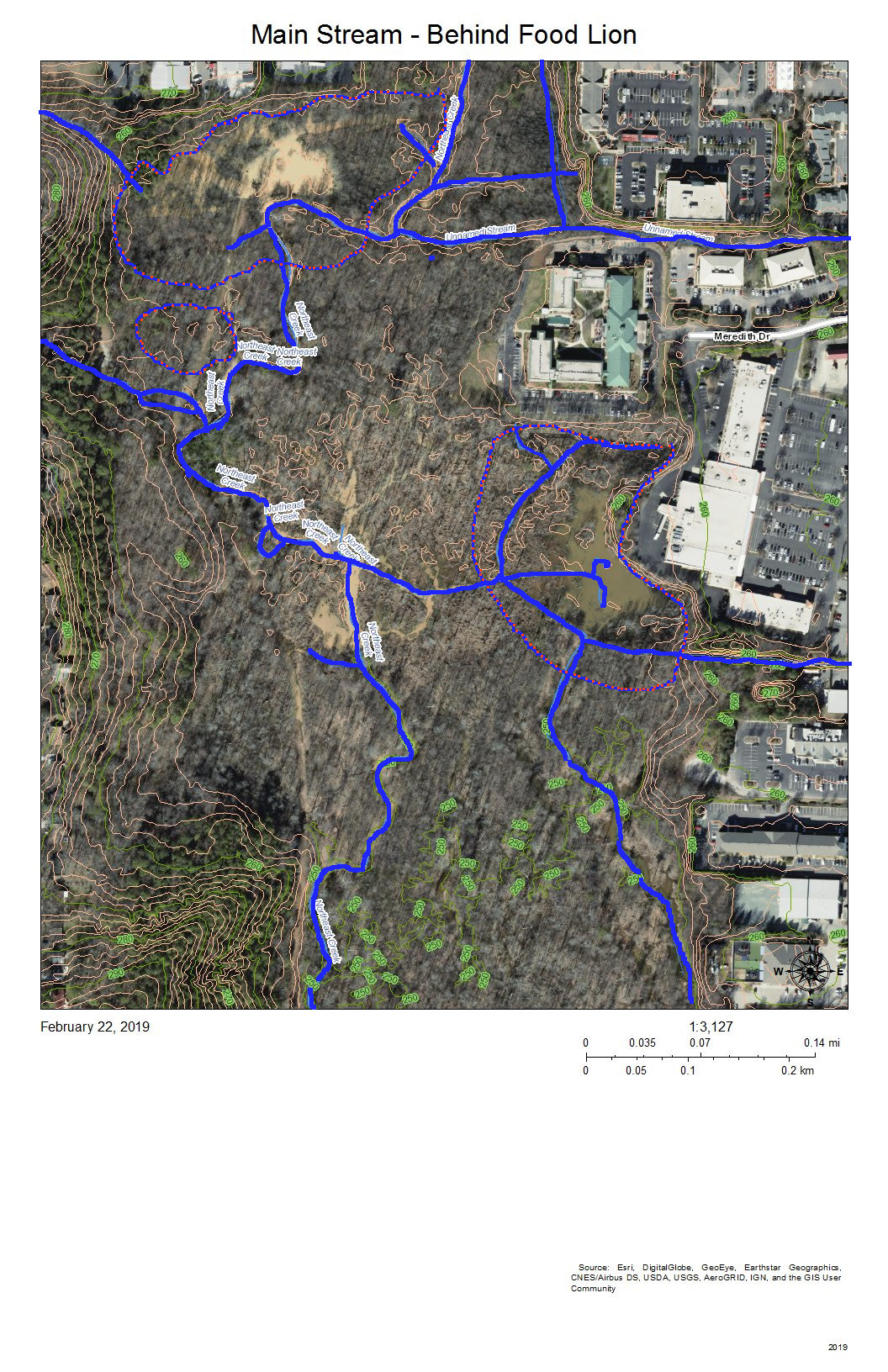
Main Stream – Behind Food Lion
The complex pattern of blue lines (stream channels) on this map shows the effects of a strongly meandering and braiding Northeast Creek and the engineered attempts to reduce flooding of the parking lots of the properties backing up on the wetlands. All of the water from the parking lots built on what used to be farmland adjacent to bottom land instead of somewhat soaking into pasture or woodlands, now all flows into the wetlands. Commercial property owners nationwide are only now beginning to investigate how to better manage stormwater on commercial properties. Local governments have mandated certain best management practices for stormwater management over the last ten to twenty years. The most obvious of these to most customers are the retention ponds on the edge of commercial developments.
The blue and orange dotted lines encircle areas of open water in the areas behind the commercial properties on NC 54 and the Food Lion shopping center on NC 55.
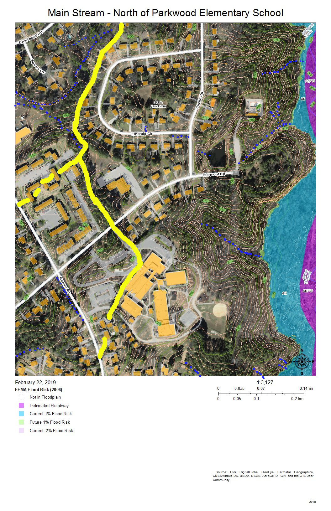
Main Stream – North of Parkwood Elementary School
The sub-basins to the left of the map drain into Tributary C (Parkwood Lake). Parkwood Elementary School has engineered stormwater management of its site. The houses on Radcliff Circle drain down the vegetated ground cover of the buried sewer outfall to the main sewer line that goes to Triangle Wastewater Treatment Plant on NC 55.
Main Stream – North of Greenwood Common
As the intensity of commercial development on the eastern edge of the wetlands diminishes and as the force of flooding during rainstorms is absorbed by the size of the bottomlands, there are fewer engineered channels and the channels go from braided to parallel meanders. The blue lines show stream channels; the blue and orange dotted lines show the perimeter of the more permanent swampy and marshy areas toward the eastern edge.
At the bottom of the map behind Greenwood Commons, the eastern side is a cattail marsh with a few snags. This marsh has been flooded by a natural dam of crushed branches and cattail stems that elevates the water impounded slightly above the western branch, which has a series of meanders. The two branches join shortly before the main stream passes under the bridge on Sedwick Road.
Main Stream East of Revere Road and North of Sedwick Road
The primary drainage between the heights at the Parkwood Elementary School building and the short ridge on which Frenchman’s Creek Drive is built is the grassed sewer line easement (solid blue line) that runs from Radcliff Circle back to the main sewer outfall easement in the wetlands; both of these easement are somewhat wet from unevaporated stormwater except in very dry periods because of the intermittent streams (dotted blue lines) and groundwater flows that allow what rainwater that does soak in to be delayed in adding to the stream flow.
Water runs off the impervious surfaces, such as roofs (orange), driveways (gray), and streets (white). The runoff that comes through the dark green forested area that have a lot of leaf litter moves much slower. The water that does percolate through into groundwater move slower still.
The simple rules for managing rainwater on your own property are:
Slow it down.
Spread it out.
Soak it in.
This area shows how the undisturbed common land buffer on the steeper upland slopes between the individual house property and the wetlands carries out those functions.
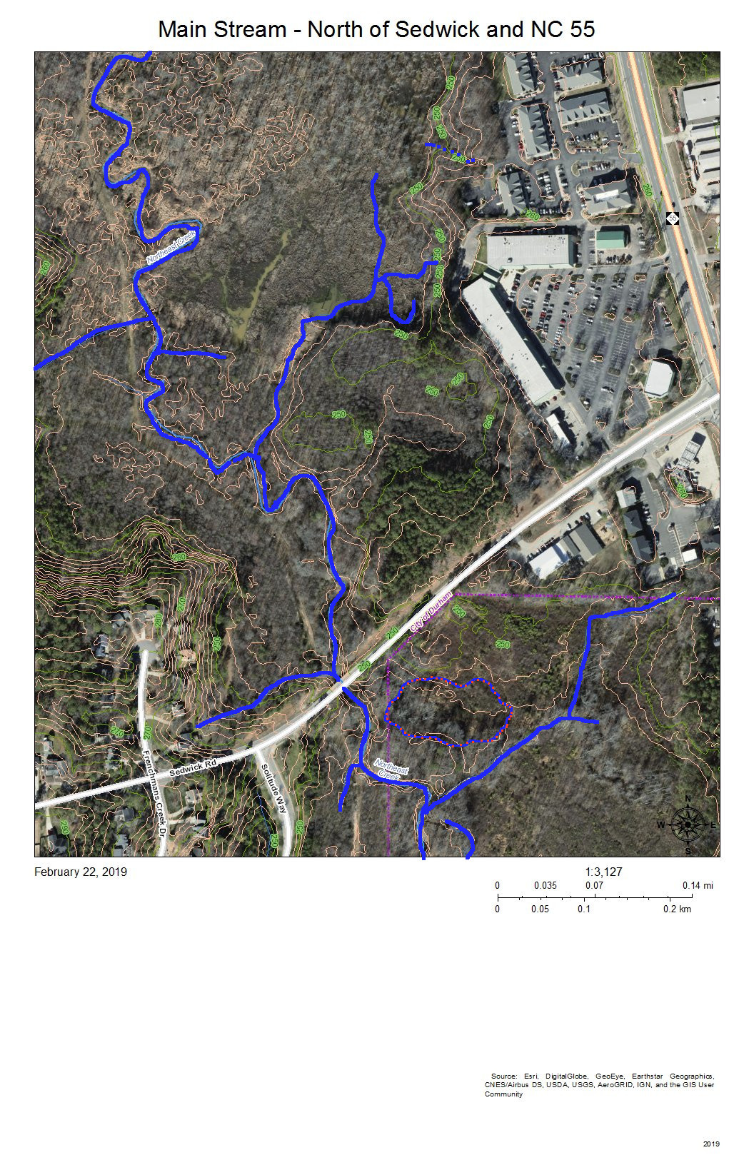
Main Stream at Sedwick Road Bridge
The blue lines show:
To the west, the meandering stream channels of the west branch of the main stream of Northeast Creek running just east of the sewer line easement that runs to the Triangle Wastewater Treatment Plant.
Coming in from the southwest, the tributary stream that has formed from the accumulated groundwater and runoff flowing from the heights of Parkwood Elementary School, Radcliff Circle, and Frenchman’s Creek Drive.
From the marsh behind Greenwood Commons, the stream channel that has flowed nearest the commercial properties on NC 55.
The joining of the two meandering channels into the single Northeast Creek main stream
A tributary paralleling Sedwick Road and draining that part of Frenchman’s Creek Drive
The single channel of the main stream of Northeast Creek flowing under the Sedwick Road bridge.
Burdens Creek and its wetlands joining Northeast Creek from the east.
A north-flowing creek to the east of Solitude Way.
An oxbow lake just southeast of the junction of Burdens Creek and Northeast Creek.
The blue and orange dotted line encircles an area that became a intermittent pond after the property was logged. The property is going through succession of vegetation and now is beginning to have small trees and forest sub-story beginning to grow. Several years ago there was a cattail marsh in this wet spot.
You can also see some of the unmarked meanders, tributaries, and oxbow lakes as darker areas near the streams.
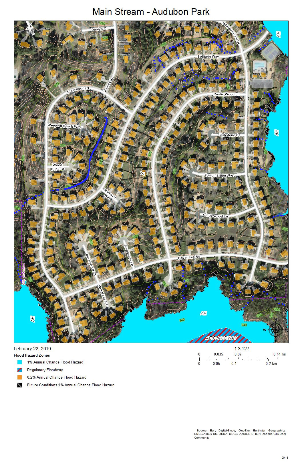
Main Stream at Audubon Park
Audubon Park was developed with intensive site preparation and most likely stormwater pipes and structures to conduct runoff quickly into the wetlands to the east and south. What appears on this map is a stream inside Piperwood Circle and Solitude Way. There are also indications from the topography that intermittent streams might form with the slope of the ground and run off at the edges of the wetlands; after almost 20 years, there might be gullying at the edge of the wetlands (near where the blue dotted lines meet the color coding of the flood zones). Homeowners in Audubon Park have the best view of how the water runs because so much of the drainage is enclosed interior to a bunch of houses and not visible by the public.
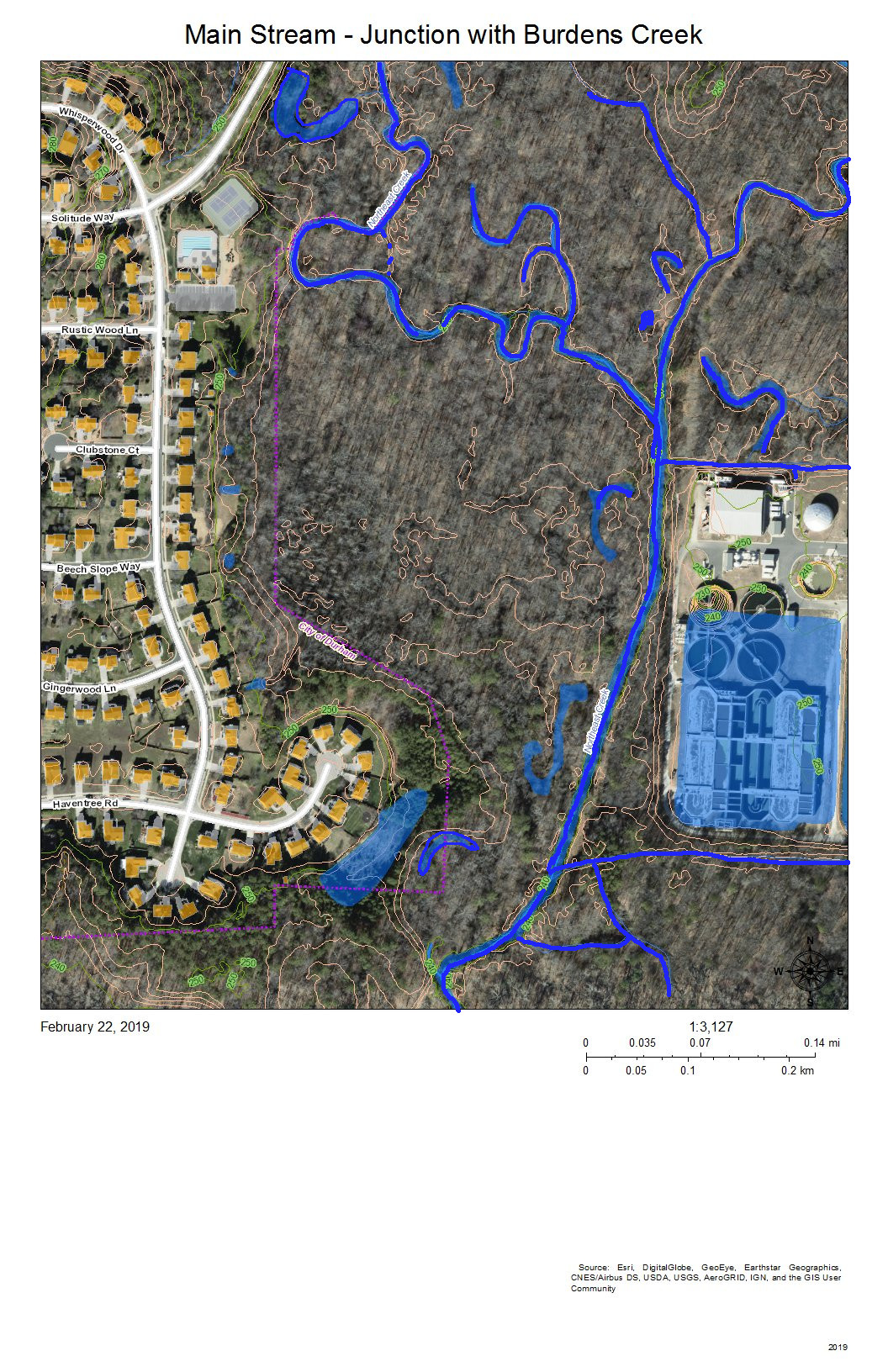
Main Stream – Junction with Burdens Creek
The wetlands east of Audubon Park show the meanders and oxbow lakes of intermittent flooding of bottomland forest in the area where Burdens Creek, coming in from the northeast, meets the main stream of Northeast Creek, meandering in from the north and making a eastward turn. The Triangle Wastewater Treatment Plant is at the lower right.
The processed wastewater coming out of the Triangle Wastewater Treatment Plant tests cleaner than the water in Northeast Creek at the outlet point. Also, the volume of wastewater flowing through the Triangle Wastewater Treatment Plant cause a baseline oscillation of roughly 6 inches (0.5 feet) in the USGS stream gage at the bridge on Grandale Road of a typical dry-period stream height of 3.5 feet. (Notice this on the stream gage report at the end of this post.)
Main Stream – Bend to the West
The main stream turns to the west around the southeast corner of Audubon Park. On the map, the development at top right is the back edge of the Triangle Wastewater Treatment Plant. The blue lines are the meanders and loops of the main stream of Northeast Creek and the tributary streams that drain other parts of the wetland.
The area on the left marked with a blue and orange dotted line locates a former swamp forest, now characterized by snags and fallen trees killed by the persistent deeper water.
The two lines across the bottom are the high-voltage power line running from a substation on NC 55 to a substation on Scott King Road by the American Tobacco Trail.
This section is where Corps of Engineers ownership of the headwaters of Jordan Lake begins on Northeast Creek.
Main Stream South of Audubon Park
This view is slightly to the west of the previous view; the area of snags and fallen trees noted at the left of the previous view is in the center of this view. To the left of this view is another swamp forest in decline.
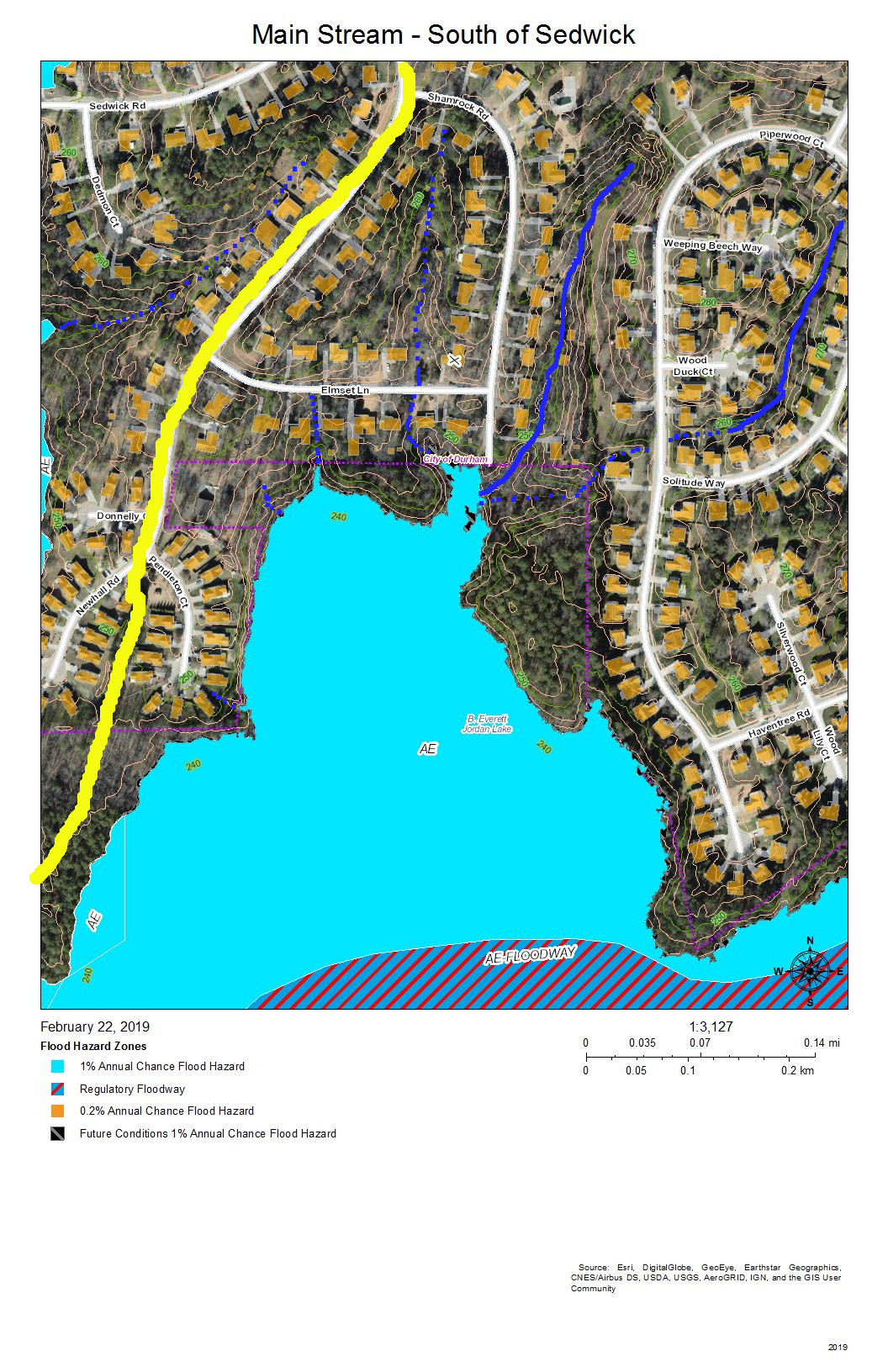
Main Stream – South of Sedwick
The yellow line is the headwaters ridge between the main stream of Northeast Creek and Tributary C of Northeast Creek.
The solid blue lines are the more permanent streams, and the dotted blue lines are the intermittent streams that drain the streets off Newhall Extension in Parkwood.
At the end of Shamrock Road is a triangular-shaped upland buffer of common land that faces out on a large freshwater marsh interrupted by some of the areas of flooded snags and fallen trees. Notice that the buffers between the newer developments and the wetlands are much narrower.
Main Stream South of Parkwood
This is the same as the previous view but without the color coding for flood hazard areas. The yellow line is the watershed ridge between the sub-basin of the main stream and the sub-basin of Tributary C of Northeast Creek. The areas enclosed in blue and orange dotted lines are areas that are more permanently wet, such as snag areas, freshwater marshes, and open ponds. There is an area in the water at the end of Pendleton Court that is light green; this appears to be algae bloom. Beyond it is a dark area of open water, and then the speckled area of the freshwater marsh. Toward the bottom left is a dark open water area, enclosed with a blue and orange dashed line, in which fallen trees are clearly visible. Within the marsh are thin, short slashed lines that are the shadows of standing trees. The open water through the marsh shows meanders that might show areas of faster flow.
On the bottom right is a 40-foot hill that forms a bluff at the southern edge of Northeast Creek.
All of the ricocheting of water in this wetland slows it down and allows it to spread across the low areas and soak in as best it can in the Triassic and floodplain soils.
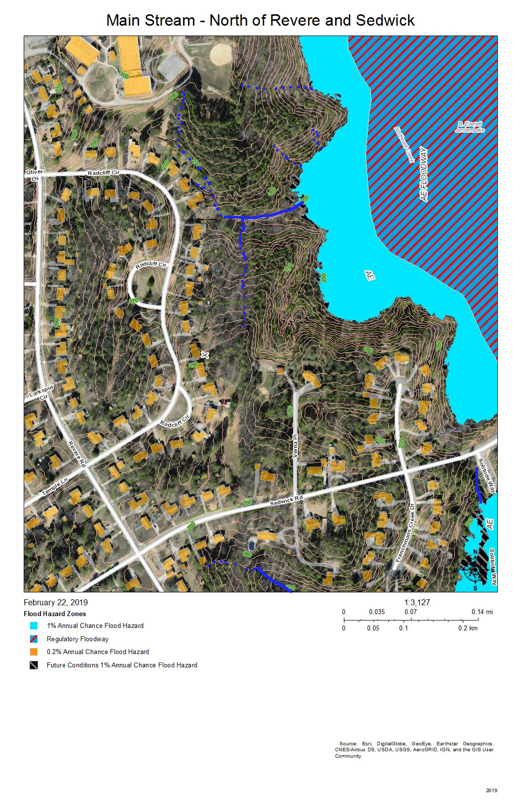
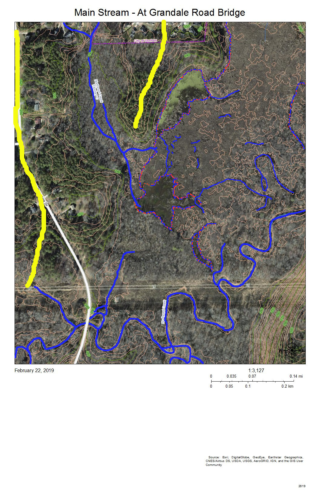
Main Stream at Grandale Road Bridge
The Grandale Road bridge is just south of where the high-voltage power lines cross Grandale Road.
The yellow lines mark the headwater ridges that separate the sub-basins of, from east to west: the main stream, Tributary C, and Tributary D of Northeast Creek.
The features of the wetland north of the power lines are those we have discussed above. This view shows more of the wetlands to the west and south.
The 40-foot hill turns out to be a 60-foot ridge that edges the floodplain on the south. Almost all of the bottom land in this view is Corps of Engineers property marked as NC Gamelands.
The USGS gage station is on the bridge. The following is the report from the month of February 2019.
USGS Stream Gage on the Main Stream of Northeast Creek at the Grandale Road Bridge
Notice the daily cycle for the first eleven days of February. That is the record of the daily release of the TWWP, just that between roughly 5.0 inches and 4.5 inches. Increased streamflow begins around February 12 and rises through multiple peaks to almost 10 feet before decreasing toward the end of the month, with one rainfall around February 28.
The yellow lines separate Tributary C on the east, Tributary D on the west, and a short minor tributary of the main stream in the middle. The meanders and islands are the pattern that the main stream takes through this section in which it is receiving the flow from Tributary D, the long, more-or-less straight, stream on the left.
The diagonal line is a natural gas pipeline easement.
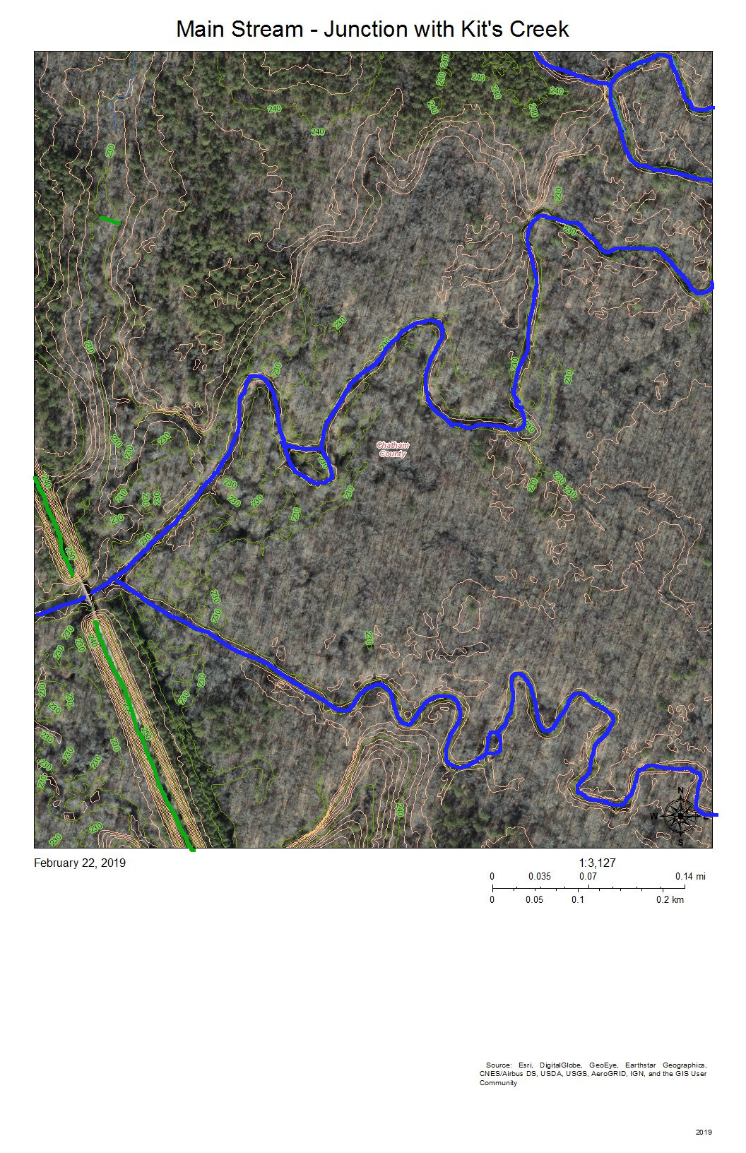
Main Stream Junction with Kit’s Creek
The green line at the bottom right is the Rails-to-Trails American Tobacco Trail (ATT) that runs from the Durham Bulls Athletic Park to the village of New Hill in Wake County. The gap is just to allow the bridge over the Northeast Creek to be visible.
Kit’s Creek (Kitt’s Creek is also correct) flows from the southeast and joins the main stream of Northeast Creek right before the ATT bridge. This junction is in Chatham County.
The area to the north of Northeast Creek is bottom land hardwood forest that includes some magnificent beech trees and shagbark hickories.
This entire floodplain down to the rookery at the mouth by the NC 751 bridge is owned by the Corps of Engineers and administered by the NC Wildlife Commission as gameland.
Another fun activity is to see where your water goes when it leaves the Parkwood area. A great way to explore this part of Northeast Creek is to hike or bike on the ATT; an alternative is to park at the parking lot by the NC 751 bridge, put in your kayak in the bay to the east and paddle upstream as far as you can (generally short of Panther Creek because of beaverdams and blowdowns).
Creek Week is coming March 13 through 20. During that week Durham is focusing attention on how individual citizens and property owners can with modest efforts deliver significant benefits to the quality of water moving downstream, especially to Jordan Lake.
A fun activity during Creek Week is to find the path that water from your roof, sidewalk, driveway, and patio or deck takes as it goes to Northeast Creek, down Northeast Creek and into Jordan Lake, and down the Cape Fear River to Wilmington.
Sub-basins of Northeast Creek in the Parkwood area
To do that, we must perceive streams and their tributary flows of runoff in the foreground and land in the background. Focusing on the flash flood zones at full flood (the flood zones identified on the Sub-basin map) shows the land as necks extending into the fully flooded lake headwaters. After all, one of the primary purposes of Lake Jordan was mitigation of the flash flooding that often occurred in the Haw River and New Hope Creek basins.
We see that Parkwood comprises parts of three sub-basins:
The main stream of Northeast Creek on the east;
Tributary C feeding Parkwood Lake in the center;
Tributary D draining the western part of the McCormick high land and streams from Hunters Woods joining and running down Wineberry to the west.
To find out which sub-basin you are in, find where your house is on the map.
For reference, look for these landmarks:
Parkwood Elementary School
Parkwood Fire Station
Gas House Shell Station
South Durham (SoDu) Farmers Market at Greenwood Commons.
Click on the image of the map. Use Ctrl-+ to enlarge the map. Now look for the landmarks.
Now trace the path the water takes from your house to the main stream, Tributary C, or Tributary D.
Are any streams by your property?
Which sub-basin do they flow into?
Where does the runoff from your house enter a stream?
Does it flow through a stormwater drain or stormwater pipe? Where does the water drain into a stream?
Does it flow down intermittent creeks that only have water when it rains?
A fun activity is to put on your rain gear when it rains and follow the water where it flows until you locate the storm drain and stream into which the runoff flows.
In February 2006, I and ten others gathered at the Grandale Road bridge over Northeast Creek to do stream monitoring and go on a hike to see spring ephemerals. Michael Pollock had a water sampling kit from City of Durham Stormwater Services, and after we tested samples from the west side of the bridge, led us on a hike.
Walking along the Corps of Engineers boundary trail on the south side of Northeast Creek, we saw trout lilies and foamflowers that had just begun blooming. Walking up the natural gas easement back to Grandale Road, we could look northwest across the creek valley to where the gas easement crossed Scott King Road.
In April we tested Northeast Creek at an accessible meander just north of Sedwick Road. And then we went for a hike to see the budding trees and the spring flowers. The red maples glowed pink; the oaks were light green; some of the trees had a bluish cast. Stepping along the soggy ground of the sewer easement was challenging, but the world of the Parkwood wetland that we were walking alongside offered more natural beauty to explore.
In May, we tested again at the Grandale Road bridge. This hike explored the east side of Grandale Road and up the powerline maintenance access road. Toward the top of that hill, we crossed over to the Northeast Creek stream channel, which we viewed from rock bluffs on the south edge of Parkwood.
I was hooked. Northeast Creek Streamwatch was the organization that understood what my wife and myself had seen in 1993 behind the Food Lion store on NC 55. We had seen a wetland with submerged trees and saplings. A great blue heron was perched on one of the saplings; a green heron perched on a slightly larger sapling nearby. That swamp has now become an open pond in flood times, most of the trees drowned. Beavers and property owners have re-engineered the water flow many times over the last 25 years. And I have become committed to preserving our Triassic Basin wetlands, their flora, and fauna for my grandchildren’s grandchildren’s grandchildren to be able to appreciate.
In the 13 years since then, the “we” that is the evolving association of people identifying with Northeast Creek Streamwatch have seen:
• Regular participation in the Parkwood Christmas Parade by puppets of a great blue heron, beavers, an opossum, and frogs.
• Spring and fall clean-ups of creeks that result in piles of dumped items for Durham Solid Waste to pick up the next week after Earth Day, Big Sweep or Creek Week.
• A class at Parkwood Elementary School about sand, clay, and silt and third graders planting and labeling native plants for a WaterWise garden.
• Library programs on the native plants of Northeast Creek and the techniques of rainwater harvesting.
• A kayak touring company that did trips up from the mouth of Northeast Creek at the NC 751 bridge almost to Panther Creek in Chatham County.
• Hikes along a Jurassic diabase dike formation to the ruins of Sears Mill, an old mill on Panther Creek.
• Testing at Northeast Creek crossing of Grandale Road, Sedwick Road, Ellis Road, and in Meridian Center.
• An umbrella magnolia by Northeast Creek at Ellis Road bridge.
• The descent of a source of Northeast Creek down a steep slope by the Durham Freeway as the creek crosses under the bridge on Glover Road, passes through a steep gully and crosses under the Durham Freeway.
• The seep behind an office near NC55 and Riddle Road that is one of the sources of the prong of Northeast Creek that flows just west of NC 55 down to Meridian Park.
• The runoff from US70 north of Miami Boulevard that flows through the parking lot of pawn shop and into woods into the back yards of folks on Peyton Avenue, yet another source of Northeast Creek; this tributary flows through Bethesda Park..
• A dump site adjacent to the creek of over 50 years duration that is grown up with red cedars, winged elm, and oodles of vines.
• Sandstone caves beneath a bluff supporting leatherwood.
• The wetlands at Ellis and So-Hi roads that extend through the RTP properties of major companies and warehouse complexes.
• The main stream of Northeast Creek in flood at the NC 54, Sedwick, and Grandale bridges.
• A crew from Hillside New Technology cleaning the litter from the blackberry growth next to the NC 54 bridge over Northeast Creek during Big Sweep.
• A mother who brought her son from their neighborhood in North Durham to participate in a clean-up of the creek that feeds Parkwood Lake because she wanted to teach him a service ethic.
• The awarding of Durham’s Distinguished Tree designation to a white ash in Parkwood and a scarlet oak on the Lowes Grove Middle School property near the creek.
• The effects of the 2007 drought at the mouth of Northeast Creek, the appearance of a prairie of grass mat strewn with large mussel shells.
• Snow and ice in the Parkwood wetlands in a picturesque meander that Durham Water and Sewer later repaired with a culvert..
• Neighbors and their acquaintances reporting sewer leaks and stormwater issues to us and we getting to see that they are indeed efficiently handled.
• The Creek Critters Puppets marching as the Krewe de Creek in the Durham Mardi Gras Parade and promoting the 2016 Durham Creek Week.
• The Monarch Caterpillar art project from Fayetteville Street Elementary School at the Monarch Festival along with the students that made it and their parents.
• The recognition as Durham Soil and Water Conservation District’s Urban Conservationist of the Year in 2016.
• The support of some 40 volunteers in the construction of Parkwood Village Association’s Wiggly Trail , erosion control, and native plant garden. Completing this project with volunteer labor and donations in-kind to match a $2500 City of Durham neighborhood improvement project grant.
• Continued collaboration with Parkwood Village Assocation, Parkwood Homeowners Association, Christus Victor Lutheran Church, Lowes Grove Middle School, Parkwood Elementary School, South Durham Regional Library, South Durham Farmers Market, and local scouts as well as many longstanding individual partners.
In the coming year the wildness will continue as we seek to grow participation in these initiatives:
Upstream Neighbors/Downstream Neighbors – The grassroots network of property owners and residents working on their own to conserve their own part of the Northeast Creek basin. Opportunities and tools to serve them are rainwater retention ideas, planting native plants, removing invasive plants, local creek clean-ups, adopting storm drains, adopting stream segments, adopting highways for cleaning litter. Citizen science activities include Audubon’s Backyard Bird Count, iNature.org, and many others. For additional citizen science opportunities, contact the NC Botanical Garden and the NC Museum of Natural Science.
Upstream Neighbors/Downstream Neighbors serves as a network to involve local schools and churches at the local level in local projects, which over the 47 square miles of the Northeast Creek basin means that seemingly small local efforts can result in large results on Lake Jordan’s quality just as small amounts of negligence have added up to a large excess nutrient problem for Lake Jordan.
Water Stewardship Network – The supporting network of schools, churches, government agencies, businesses, and voluntary associations that have an impact on Northeast Creek and ally with similar groups in other watersheds. These institutions support individual efforts as part of Upstream Neighbors/Downstream Neighbors. These are the locations of events, demonstration projects like gardens or rainwater treatments, and educational programs. They are Upstream Neighbors/Downstream Neighbors for their own property. Northeast Creek Streamwatch’s water stewardship network can tie into the North Carolina Watershed Stewardship Network (http://wsnet.renci.org/huc_report/index.html?huc=030300020605).
Creek Week and Big Sweep Events – The twice a year momentum builder for local efforts. They get people out into the stream environment and wetlands, show the natural beauty, and get something tangible accomplished with a very short commitment of time. This year’s Creek Week is March 17-23, 2019. Start planning local events for March 15 -23 and notifying colleen@northeastcreek.org.
Thomas Rainer and Claudia West, Planting in a Post-Wild World: Designing Plant Communities for Resilient Landscapes, Portland, Oregon, Timber Press, 2015, 271pp.
Douglas W. Tallamy, Bringing Nature Home: How You Can Sustain Wildlife with Native Plants, Portland, Oregon, 2007, Timber Press, 358pp.
Andrea Wulf, The Brother Gardeners: Botany, Empire, and the Birth of and Obsession, New York, Knopf, 2008, 359pp.
Rainer and West in Planting in a Post-Wild World write:
…[A] new way of thinking is emerging. It does not seek nature in the remote mountain tops but finds it instead in the midst of our cities and suburbs. It looks at our degraded built landscapes with unjaded eyes, seeing the archipelago of leftover land—suburban yards, utility easements, parking lots, road right-of-ways, and municipal drainage channels—not as useless remnants but as territories of vast potential. We pass them every day; their ordinariness is what makes them special. As such, they are embedded in the fabric of our lives, shaping our most recurring image of nature.
The traditional landscaping that we inherited from the early gentlemen and merchants and their gardens evolved into landscape culture of “naturalness” as the picturesque preference for long views, open landscapes, clean edges, and touches of mystery. As a result, the general public has little tolerance for wild, illegible landscapes and plantings, especially in cities and towns. When people encounter highly mixed plantings, they are often reminded of abandoned fields or derelict industrial sites, places often associated with urban decay or neglect.
Rainer and West give us an alternative vision that can begin with our yards and be adapted to our communities.
So what exactly is the planting of the future? Look no further than just outside your front door. Go find a patch of weeds in your neighborhood. Notice the variety of species and how they interweave to form a dense carpet. Or better yet, take a hike in a nearby natural area. Look closely at how plants grow in a meadow or a forest’s edge. Observe the lack of bare soil and the variety of ways plants adapt to their site. Then when you get back to your neighborhood, compare those wild communities to the plantings in landscape or garden beds. There is a difference between the way they grow in the wild and the way they grow in our gardens. Understanding this difference is the key to transforming your planting.
…the solution lies in understanding plantings as communities of species that cover the ground in interlocking layers.
Notice that the question for gardeners shifts from what to plant to how to plant.
By focusing on naturally occurring plant communities, as opposed to those that are purely native, the focus is shifted from a plant’s country of origin to its performance and adaptibility.
All it takes to become a plant community is:
1. All plants should survive in similar environmental conditions.
2. Plants must be compatible in terms of their competitive strategies, the key to having plants that last.
The practice is to cover the ground densely by vertically layering plants. As the light levels drop under a tree, grasses transition to a mass of ferns, maintaining a continuous sea of plants. The bases of trees where traditional planting often piles mounds of mulch can be filled with plants (green mulch) instead. Any space around the base of a plant is a space waiting to be filled. Even low plants benefit from being under-planted with creeping plants.
Rainer and West talk about ” naturally occurring plant communities, as opposed to those that are purely native.” Doug Tallamy in Bringing Nature Home is an entomologist concerned about the insects that consume native plants and support native insectivores, like birds and amphibians. Tallamy goes to the ability of the native insects to survive on the plant, regardless of its origin but notes that even alien plants with similar origins accommodate fewer insect species than native plants. The ability of insects to survive to eat and pollinate the next year’s crops of native plants is critical to the survival of those native plants. As habitat is destroyed in development, as pesticides and herbicides are broadly applied without planning, the links between native plants, native insects, and native birds are broken and we start to notice population declines of birds and popular insects, like butterflies and showier moths. Tallamy describes these relationships in his chapter, “What does bird food look like?”
Whatever else it is, local habitat extinction is a local ecological and horticultural crisis. Having the native plants for native insects is the security for the habitat of the rest of the food web. And whatever impact native insects have on alien plants, alien insects frequently have had devastating impacts on native plants. And alien insects are frequently transported on alien plants.
How did we get so enamored of ornamental exotic species in the first place? Andrea Wulf tells the tale of how, on the British side of the Atlantic, wealthy gentlemen and merchants with networks of correspondents around the world traded plants from one continent to another. Andrea Wulf’s The Brother Gardeners describes how that correspondence and shipment of boxes of plants produced the explorer-botanists who would search out and ship the boxes of these new exotics as they were laying the foundations of the science of botany in the midst of Britain’s expansion of its empire. She then traces that history to the English obsession with gardening that was exported to America.
Peter Collinson had a correspondent in Pennsylvania named John Bartram, who regularly shipped him boxes of native plants from the eastern coast of America. Another correspondent, a Father d’Incarville sent seeds of Ailanthus altissima from China to Collinson in England in 1751; within a few decades, the tree of heaven had arrived in America. Because it is resistant to pollution, it was widely planted. Today it is considered an invasive species. In 1739 the Camellia japonica camellia had arrived in England and was on its way to America. It is one of the mainstays of ornamental exotics and quite well behaved; its popularity increased the replacement of native plants (such as rosemallow) with ever more camellias. In fact, the default landscaping for local gardens tends to be these exotics that are the result of 300 years of globalization.
Wulf’s book introduces some of the early scientific botanists, such as Mark Catesby, whose Natural History of Carolina, Florida, and the Bahama Islands, (London, 1731-48) contains some of the earliest paintings of native plants and animals in the Carolinas. She follows the obsession with gardens that spread from France to England to America; a subsequent work of Wulf’s describes the gardening obsessions of the four first US Presidents, to whom much of our current styles of landscaping owe inspiration.
Upstream Neghbors/Downstream Neighbors Project hosts a Save the Rain Workshop
As homeowners, we can extend the principle of catching and holding rainwater to restrain how much water and how fast its flows downstream during a rainstorm. These actions can affect the amount of erosion of stream banks in downstream neighbors’ yards and reduce flooding of downstream neighbors’ property. We can also save back some of that water for dry spells, hold it long enough to recharge the water table here instead running rapidly the length of the Cape Fear River, and create more habitat for pollinators.
A reasonable goal is to capture the first inch of rainfall from the square feet that your property has as impervious surfaces and hold it for up to three days. There are a variety of ways to do this; the county Soil and Water Conservation District (in Chatham, Durham, and Wake counties for Northeast Creek) can provide technical assistance and tips for beginning your plan of rain saving. And you need not hit the goal of “one-inch saving for at least three days” all at once; you can try different combinations of techniques on your property to see what works best.
For the second year, Cory Quammen, a resident of Grandale Forest on the headwaters of “Tributary D” of Northeast Creek, is holding a gathering of his upstream and downstream neighbors, Saturday, October 22, 9am – 11am to show some examples of problems caused by excessive runoff as well as some rain-saving measures that have been installed on his property.. Invitations will go to the neighbors within his local creek basin in advance of the meeting. Contact cquammen@gmail.com for further information.
Upstream Neighbors/Downstream Neighbors Project holds Save the Rain workshop at South Regional Library on February 4, 2016
The Upstream Neighbors/ Downstream Neighbors project hosted Mike Dupree of the Durham County Soil and Water Conservation District at the South Regional Library on February 4. Mike informed us about the services that his department of county government provides to property owners and why these services benefit both the property owners and the quality of water—specifically in Northeast Creek and in Jordan Lake.
In introducing Mike, Cory Quammen shared how the Durham Soil and Water Conservation District is helping owners of property that backs up on a creek in his neighborhood with flooding and stormwater issues.
Mike will be speaking at the Eno River Unitarian/Universalist Fellowship (ERUUF) on Wednesday, February 24 at 7:00 pm. His topic will be managing water, nutrients, and pests.
Thanks to everyone who came to the South Regional Library. We would love to hear feedback from those of you (5) who set appointments for Mike to consult with you about the issues with your property. Send your comments to colleen_haithcock@yahoo.com.
For those who wish contact Mike Dupree, it is mdupree@dconc.gov or 919-560-0558.
Here is a link to a video about the Voluntary Nutrient Reduction Program that Mike Dupree described February 4.